Blog Archive

Wednesday, August 31, 2005

Current Katrina Info-Map (Google Maps)

A very useful Google Maps tool has been established to enable individuals to post known information about Katrina-affected areas in the southern U.S. states. If you are trying to obtain current information but are having a difficult time, this interactive Google Map might be of some use to you. To ensure that this map remains of use to those looking for information, please heed the request to not place markers on the map asking for information.


If you are interested in donating to the Hurricane Katrina Red Cross relief, please visit the Red Cross website.

[via]

BBC Sport + Google Maps = Sport Map

+ = Sport Map!

Here is a very impressive and functional UK Google Maps mashup which takes BBC Sport RSS feeds and mashes it up onto a Google Map. The map interface that is employed in this mashup is a clever way to find regional information on a Google Map interface.

Start by centering the map in a location within England (perhaps London). When you are zoomed into an area that you are interested in, click your middle mouse button (if you have one) or the F2 key. In the left pane the nearest football club is displayed, along with all the latest BBC Sport news headlines and stories for that region. Give it a go!

2 new Washington D.C. transit mashups - take your pick!

I was tipped off about two separate Washington D.C. Google Maps transit mashups on the same day so my only choice is to show you both of them for you to decide which is better. Both are quite similar (as many of the transit mashups are) but you will notice extra features in one over the other. Each of them are mashups of the WMATA (Washington Metropolitan Area Transit Authority)

DCRails.com


WMATA Maps

Frisbee-Golf Anyone?


Marc Melcher has created a resource for those of you in San Francisco playing "disc-golf" in Golden Gate Park. He toted a GPS device around with him to plot each tee location and then got to work with the Google Maps API creating this nifty little map. You can get in on the action by checking out the San Francisco Disc Club webpage.

If you're serious about the sport - don't forget about the Disc Golf Course GMap which shows you all the locations in the U.S. to play!

Could this be the next Olympic demonstration sport?? :)

Tuesday, August 30, 2005

Taiwan Typhoon Google Maps mashup..


As the cleanup begins in the southern U.S. from Hurricane Katrina, folks on the east coast of Taiwan may want to start preparing for the 4th typhoon of 2005 in that country. This Google Maps mashups for the country of Taiwan displays live paths of typhoons near Taiwan in Southeast Asia. The records of each typhoon are fetched from Central Weather Bureau of Taiwan automatically every 30 minutes.

Monday, August 29, 2005

United Airlines mashup now includes all OneWorld airlines

A while back I posted about a mashup that takes the United Airlines timetable and mashes it up on a Google Map for you. The creator of this mashup has just informed me that all OneWorld airlines are now accessible from the search-tool! Check it out..

ZDNet Goverment blog encourages government Gmaps mashups

Update Aug. 30/05 AM: fixed a few text errors caused by the Blogger spell checker. ;) - Thanks Alex!


The ZDNet Goverment Blog is calling for more government-backed Google Maps mashups. In this post, they have this to say:

So far, although much of this stuff is based on government-supplied data, we haven'’t seen any mashups created by government agencies. This would be really be e-government and citizen-based government in action. (read the entire post)

UK-based IdealGovernment.com has been on about this for some time. They started the competition geared toward Google Maps mashups using publicly accessible government related information. They recently announced winners for that competition.

[via]

3 new Google Maps fitness and recreation mashups!

Google Maps mashups have definitely found their way into the fitness and recreation world. The GMaps Pedometer got the "wheels turning", and since then many more have followed. Here are some more..
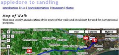
Walking

This UK Google Maps mashup is a great example of how community walking clubs or local e-government websites could encourage active living over via the web. This web-based tool allows you to plug in the type of walk/hike you're looking for, and then lists the local routes that would best suit your needs. The resulting walks contain a Google Map link with the route laid out, and even shows the nearest rail station marker on the map that is closest to that route. [via]


Running:

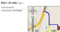
FavouriteRun.com is a site which allows you to plot your running route and display it for others. Simply login to create an account or use the search tool to look for runs based on U.S. zip codes or search tags. The creator says that it's not quite as full-featured as the Gmaps Pedometer but does allow you to store your routes and display them for others to check out. [via]


Online Training:

Apart from the individual fitness maps mashers, companies are getting into the act by integrating their mapping software with their existing products and services. MotionBased.com is one of those companies that has started to perform such an integration. MotionBased is described as the following: Using data collected from GPS devices, MotionBased empowers its customers with online data and mapping analysis, unattainable with the current set of products available to endurance athletes. Check out the MotionBased.com blog entry for more information on their Google Maps integration.


If you're interested in other existing fitness and recreation Google Maps mashups, check out the Fitness and Recreation links section on this blog for some more that I have found. Keep the fitness and recreation Google Maps mashups coming! They are empowering thousands of people to stay fit and active!

UPDATE: Google Maps Hurricane Katrina trackers

This is just a reminder from my post on Friday that there's a pretty good Google Maps Hurricane Katrina tracker here. Also, if you are a Google Earth user, check here for a satellite overlay to track the storm as it heads inland.

Update - Aug. 29th, 10:45am EDT:

- More overlays for Google Earth to track Hurricane Katrina here.
- Live river flood gages found here. [via]
- Lots more "disaster tourism" links for Hurricane Katrina here.


Related News/Photos:
Flickr: Hurricane Katrina
Google News:
Hurricane Katrina
Technorati Tags:
[Katrina], [Hurricanes]

Sunday, August 28, 2005

Online newspaper makes its own "cheap gas" mashup

Update: Link corrected (Thanks Esa!)

The New Media Department at The Times Herald-Record in the Catskill and Hudson Valley region of New York State have created their own "Cheap-Gas" Google Maps mashup for that region. The mashup was created entirely by the media team at the online paper and does not utilize the GasBuddy+GMaps integration that some other U.S. newspapers have integrated. This is one more example of how the media is starting to integrate Google Maps into their online operations!


[via]

Fun Google Maps tool you're really going to "dig"!

Remember when you'd dig a hole in your backyard or at the beach as a kid, and you'd hear friends, parents or a passerby say to you: "If you keep digging, you're going to reach China!" Well, Luis Felipe Cipriani of Brazil is going to help you find out if they were right. He's created the "If I dig a very deep hole, where I go to stop?".... Google Maps tool. :) This will help you determine where, if you were to dig a hole straight to other side of the earth, you would end up!


Luckily for me when I was younger, I stopped digging that hole before letting all the waters of the south pacific gush into my backyard sandbox. That would have been bad. ;)

Does anyone reach China? If you, post a comment and let us know!

Google Earth video shows an awesome look at Seattle!

I generally try to keep my posts on Google Maps Mania focused on Google 'Maps' related material rather than Google Earth stuff. This is mostly because there are other blogs that cover off Google Earth quite well. To steer from my usual theme, I would like to recommend you check out this amazing video created by Peter in Seattle using Google Earth and Apple QuickTime (must be installed to watch). This video swoops you down to various points around the city of Seattle, then cuts to a short video clip of the actual location (with pretty cool music too).


The video is an awesome example of what city tour companies or municipal tourism council's could be doing to showcase the highlights of their cities!

Saturday, August 27, 2005

Google Maps Crime Map: Ypsilanti, Michigan


Brian Robb has created a great little mashup that displays crime data from the city of Ypsilanti, Michigan (USA) on a Google Map interface. This mashup is a good example of how Google Maps mashups don't require a lot of coding and technical knowledge in their creation. Brian, a self-professed "non-programmer" takes crime information in Word format and then runs a manual latitude/longitude lookup to get the coordinates, which is overlaid onto a Google Map. He then lists the maps by week. (I could see small weekly community newspapers performing such a function to display the past week's police calls for their website visitors).

Brian was inspired to create this crime mapping site after seeing and using the trailblazing ChicagoCrime.org but notes "We are only 22,000 residents and there's not as much crime as a city of seven million."

Google Maps Mania - A Japan View

IN..
Google Maps Mania - "The Japan View"


nagoyan the earthhopper is our eyes and ears for what is happening in the Japanese Google Maps world. He's back to help Google Maps Mania readers understand all the great things happening in this language on the web. (I'm looking for Google Maps Mania correspondents in other local languages - Spanish, French, Portuguese and Mandarin/Cantonese.. If you're interested, drop me a line!)

Hi, this is nagoyan the earthhopper again, from Japan. We have recently got relatively large earthquakes near big cities - Tokyo and Sendai, and even big Typhoon #11 just hit the area around Tokyo (it's called Mawar, but we don't usually call them with human name). People are well prepared for fatal disaster like epicentral earthquake, but they are trying to be best in various ways - one of current best-selling book is the customized handy maps that instructs how to walk back home from central Tokyo just in case of disaster situation while many of lifelines are not available. This maps cover most of directions from major business districts where 4+ million people commutes from outside of Tokyo mostly by trains and subways, with good instructions where to get medical relief or food/water, and designated emergency evacuation areas, even where to avoid. I hope they could issue English one for sure.

sinsai.jpg

So here we go for today's edition of Japan View.


Posital - tell your family and friends where you are in earthquake disaster

In earthquake disaster situation, just like one in Niigata last year, it's going to be difficult to get connected as mobile phone network might be congested or internet routers damaged. Posital provides "where you are" functionality using Google, Yahoo and Mapfan maps, and the location info is shared only for the people you permitted. And using a screen saver application on GPS mobile phone by au, you can automatically update it, even keep informed about your friends.
Poital even provides social network community, fully supported by geotagging. You can predefine your various human relationships (like family, lover, close friend, friend, acquaintance and anonymous) and what info to open to whom, then communicate in very organized way. Also you can geotag to any of info you have created - bookmark, RSS feed of blog entry, news, merchandise at Amazon, BBS thread etc, and syndicated with other social network like mixi (just like Wallop by Microsoft Research).


posital.jp 1
Showing where you are only for your family and friends


tabelog.com - Restaurant guide by pro-reviewer and fans


tabelog.com is a new restaurant guide service of kakaku.com, a very large price comparison service company. This guide is looks like sfsurvey.com, as you can narrow the search on the map and each reviewer posts impressions and place them on his or her own map. The uniqueness of this guide is that it employed professionals like food writers as well as ordinary food fans to reinforce their contents than others. Also, each of registrant will have their own page, map and favorite reviewers. kakaku.com released another Google Maps mashups for world heritage travel guide and hotel reservations to leverage their services to compete with others.


tabelog.com Googla Maps mashup
Chieko Asazuma, a pro food writer reviews lots of restaurant in Tokyo.
You can browse her reviews on her own map.


Guide to Japanese Castles to feel medieval era

It is always good to revisit the history with the map in your hand for most of fans, including myself, and the Japanese castles always symbolize great stories. Eric Obershaw, one of those fanatic, created comprehensive database of 50+ castles, mostly his personally visited, with a cool Google Maps mashup. This includes most of my favorites, like Gifu Castle (my flickr photo), which was built by my hero, Oda Nobunaga, or Aizu Wakamatsu (a.k.a Tsurugajo - f) and Himeji (f). Hopely he can add my another favorites, Kanazawa and Kumamoto, but this is great work for us.


Castle Map
Castle Map
showing location of Gifu Castle

That's all for today.

nagoyan the earthhopper

Friday, August 26, 2005

Hurricane Katrina Google Maps mashup

FLHurricane.com has a Google Map tracking Hurricane Katrina, which is currently passing over the state of Florida in the U.S. Check it out here. The map-pegs show day & time, wind speed, pressure and movement as the storm continues to track.


Here is another interesting map on the same site that plots all 2005 storms around the state of Florida.


Related:
Flickr: Hurricane Katrina
Google News:
Hurricane Katrina
Technorati Tags:
[Katrina], [Hurricanes]

[via]

5 new Google Maps mashups!


Real-time locations of Aircoaches in Dublin, Ireland - Wow, Dublin is becoming the place for real-time Google Maps mashups. First came the commuter train locator, then came this.. A mashup that tracks the locations of Aircoaches to and from the airport. Check out this blog entry for a short description of what it's about and how it's done. Real-time Google Maps mashups for objects on the move are the best!

Beyond Google Earth - Track Asteroidal Occultations - This Google Maps mashup tracks the asteroidal occultations that will be visible over North America, Central America and the Caribbean during the next month. The maps for each event will show the path of the asteroid above the earth. Each map that is listed for the upcoming asteroid "streak-bys" (this is an official Google Maps Mania astronomy term) also includes a link to a Google Earth download to track the event using that application. Pretty nifty. I had no idea there were this many asteroids crossing by earth!


TravelByGPS.com powers site search with Google Maps - TravelByGPS.com provides GPS data for recreational activities. Visitors can download lat/lon coordinates for hiking trails, fishing holes, SCUBA dive sites and sightseeing tours. They've just implemented Google Maps as a way to allow site visitors to search for content geographically - a Geographic Search Engine. Try it out.

A few more: Virtual New York City Tours and a Vancouver, Canada Transit Map
[via]

Thursday, August 25, 2005

Mashups and Tools Index updated: 49 links

I've just updated the Mashups & Tools Index along the right side of the page with 49 links that I've reviewed and talked about in recent posts here on Google Maps Mania. If you haven't checked out this links list in a while, now might be a good time.

Google Maps Mania has been in the news and the blogosphere quite a bit lately.. Check out GMaps Mania References to see all the places we've been mentioned and linked from!

JourneySat: New Google Maps Tool

You travel, everybody sees with JourneySat and Google Maps - From the website: JourneySat lets you show to your friends and relatives the places you've traveled to. You can combine diary notes, photos and satellite images and embed them into your web site either when you're back home or when you're still on the road. After writing a diary note and adding the photos of the day, you can find out the exact geographical location of the places you've visited to let your friends see them from a satellite viewpoint, using the images provided by Google Maps. In this way they'll see much more than what can be normally experienced through photos. As a further bonus, you can even specify the locations where you shoot your photos and they'll be marked on the satellite view. Take a look at the site..

[via]

Google Maps for your Blackberry - HelloWorld app updated!

+

Back on August 18th I posted about a new Research In Motion Blackberry device application called HelloWorld. The application creator Dan Janulewicz has just posted HelloWorld v1.1 which is available to Blackberry users for download at the location listed below. He writes:

I've posted HelloWorld v1.1. You can now choose your connection method as:
1) BES

2) Direct TCP

3) WAP
New features include (satellite mode, map scale)


You can install it OTA (over the air) from www.freek.ca/beta/HelloWorld.jad

..To date HelloWorld has seen over 800 downloads!

Google Maps on video..

Here are a few examples of Google Maps presented to you by web-video (QuickTime and Flash are required). Both of these visuals will help you understand the evolution of a Google Maps mashup - literally from start to finish!

The first video clips are for those of you tackling the Google Maps API to create all these awesome Google Maps mashups. This person has created a 2-part instructional video covering the Google Maps API and how to integrate a Google Map into your website. The pace is good, and the speaker is very thorough in his explanations. Here are the links:

Phase I: will get you up and going with a simple google map.

Phase II: We will take your address and build a google map on the fly, If you don'’t have the longitude or latitude, we will do a SOAP call to ServiceObjects.com get the longitude or Latitude coordinates, then update the database, so we don'’t have to do the SOAP call again, then we show your map, best of all you can download working code here.
(Macromedia Flash required for both)

Both clips are linked from this page.
[via]

The second video is an 8 minute screencast demonstrating the Google Maps interface and the GMap Pedometer Google Maps tool. The creators of the video show, with the Gmaps pedometer, how far John Lennon would have had to walk to visit Paul McCartneys house when they were living in Liverpool, UK. :)
Folks - let me know if this clip doesn't open for you. I'm not sure if it's just my version of QuickTime.

(Apple QuickTime is required)
[via]

Have fun! :)

Wednesday, August 24, 2005

2 new Google Maps mashups!

Take a Heritage Walk in Nanaimo, British Columbia - The city of Nanaimo, BC, Canada has employed Google Maps and other web technologies to create this amazing Heritage Walk around the downtown core of their city. Upon clicking the pushpins on some of the locations, a java viewer opens in the balloon allowing you to pan and view the area you've just selected. Within the panorama red icons appear indicating a heritage site. Clicking these icons brings you off to the Heritage Register's website to view the record for that property.

Heavy on plugins, this site may bog down your browser as a general warning. Gisuser.com also reports that you can explore this Canadian city even further using Google Earth in this article. I echo their comment: "Kudos to the City of Nanaimo for being so proactive and for allowing their IT department and GIS crew to dabble with technology." [via]

Tonight: Live Bands found on Google Maps! - Want to see a live music act somewhere in the U.S... tonight? Jambase.com has added a Google Maps mashups that displays live concerts which are playing in various U.S. cities for tonight.. and tomorrow night.. and the night after that! [via]

Google Talk mashups on the horizon?

Google Talk was released today, Google's foray into instant messaging and Internet-based communications. Will we see Google Talk + Google Maps mashups in the coming weeks and months? Maybe a tool that plots your friends list to a password-protected private Google Map, or an extension in some form that allows you to map users to Google Maps directly from Google Talk?

Time will tell.

Tuesday, August 23, 2005

Will ads target the satellite cameras? (Part 2)

Back on May 9th, I posted the following:

Will ads target the satellite cameras?

Will Google Maps satellite views give way to more "aerial" advertising? Nootropic thinks so. This blogger points out a Pepsi logo from a waterpark in Tempe, Arizona and wonders if more ads will be targeted toward the watchful eye of a passing Googlezon satellite. :) Suddenly a brand or logo on the top of a building is visible to more people than just those in its flight path...


The discussion continues today with a few more conversations I found on the topic out in the blogosphere.

The Design Weblog has posed an interesting thought:

..But what if these acres and acres of untouched, up-and-coming prime marketing real estate went up on the advertising market? This could make for some interesting adventures in advertising.
(more)
(..Check out the image they have put up in this posting for a good visual example)

They also reference another posting over at Be A Design Group..

But what if satellite images and/or aerial photos will be updated more frequently, and people will use roof-tops for advertising? Consider big convention centers, or hotels that are very spread out. That'’s a lot of roof real estate. Viewers would see the large ads while looking up an address near-by. I know that doesn't sound like a definite ROI, but it might be an option for a company, like a convention center, that wants to put their logo or contact info in noticeable colors on the roof so that people looking up directions for places near-by would see the ad.
(more)

With the ad industry shifting it's focus away from traditional arenas like television and into places like online games and the Internet, it's a sure bet that the predictions that are being made in these posts will end up happening. Let's hope it's not a cloudy day for the ad industry when the Google cameras zoom by for a snapshot. ;)

Google Maps in the news..

The Branding and Mapping Mash-Up - Clickz Aug. 23/05
What could a map and a brand possibly have to do with each other? Nothing much -- until recently. Almost overnight, geography, and the part it plays in connecting brands with users, seems to have developed yet another amazing opportunity for brand builders. (Read more..)

Goofy Google Grinch - NYPost - Aug. 21/05
A Queens assemblyman says a popular new program offered by Google could help terrorists scout targets like the White House, power plants and transportation hubs — and is urging the search-engine giant to shut it down. (Read more - requires free registration..) [via]

You Are Here (We Think ...) - LA Times - Aug.21/05
In fast-growing areas, outdated maps can leave residents feeling, well, uncoordinated. (Read more..) [via]

Eve: The Exciting Venues & Events browser

(update 12:01:55 PM EDT: links fixed - Thanks Ron!)

Marc Chung thought it would be cool if he had a map of the city he lived in, and it showed every venue and event that was taking place near him. Turning vision into reality, he got to work with the Google Maps API and created "Eve: The Exciting Venues & Events browser". It mashes up EVDB.com event listings and Google Maps to display a unique choose-and-view framing technique that allows you to narrow down your search in a very cool way.


The creator informs me that there are many US cities which have just been added to Eve and there are a few more features to be added. Check out this mashup in the making and give him some feedback!

[blog entry]

Progressive online news website integrates with a GMaps mashup!

CyberJournalist.net has mentioned that North Carolinian news website The News & Observer has integrated a GasBuddy.com + Google Maps mashup module directly into their front news page to display the cheapest gas prices in the area. This shows the creativity and vision of this news organization to recognize the value of Google Maps and this unique mashup for their readers.

The News & Observer website:


[via]

2 new Google Maps mashups (with a Boston twist)

EventJAR city guide/events site integrates Google Maps (Link example: Boston Map) - An EventJAR press release reports: "JAR Networks today announced that EventJAR.com, a rapidly growing travel website, continues to expand its successful travel information service with the launch of LocalGeo. The new feature offers travelers a new and unique visual view of local destination content." I've sampled their integration and although using Firefox I do get an error telling me I have an unsupported browser, it does continue to work. [via]

Boston24 shows you all-night stores/restaurants on Google Maps - Boston-Online has announced "Boston24", a mapping site showing you 24-hour stores and restaurants in the Boston area. The site also features a links and comments app for full interactivity.

Monday, August 22, 2005

4 new Google Maps mashups!

A Google IP address Geo mashup - Here is a tool that is similar to Whereis which does a reverse lookup on your incoming IP address and centers it on a Google Map, along with telling you what your current city is. The tool also tells you how many miles you are from the server doing this lookup and allows you to search any IP address. Does it work for you?

Crusty, Saucy, Cheesy Google Pizza Map for NYC - SliceNY.com has started to plot locations of pizza places pegged on a Google Map within their site (with great little "pizza-pegs" to show the locations!).

This should be a great marketing tool for this vertical business directory to get
more pizzerias to join on with them!

SimplyHired.com adds maps to show you where the jobs are - SimplyHired.com has added Google mapping functionality to their job search tool so that after you have ranked your preferred jobs, you can view the location of the job posting.

I'm personally surprised that there aren't more jobs sites integrating Google Maps. Maybe more are working on it, but just haven't completed their integrations?
[via]

Hotspots in Sevilla, Spain - This user has created an overlay to his favourite hotspots in the city of Sevilla, Spain. Locations include pizzerias, tapas and other places to visit. It's a shame that people living outside of North America, the UK and Japan have to live with creating mashups and overlays using satellite photos on Google Maps. Hopefully this won't be the case for long as street maps for new countries will definitely make way for new mashups in countries like Spain. [via]

Spending a week with the Google Maps API

John Resig has spent the previous week sharing all of his knowledge of the Google Maps API on his blog in a series of tutorials titled "Spending the week with Google Maps". He sets the stage with Part 1:

Starting today - and going until next week - I will be writing a post, everyday, detailing a chunk of Google Maps API-enhancing code that I've written. During the past couple weeks I've been working a number of contract jobs - all of which have centered around the usage of the Google Maps API, a powerful tool for programmers. As I've gone along, there have been a number of features that I've developed (or found) that I think other programmers would benefit from knowing. (more)

All seven of his entries: (1), (2), (3), (4), (5), (6), (7). They can also be found on the front page of his blog.

[via]

4 new Google Maps mashups!

Germany's Spiegel Online news site gets mashed up - Here is a nice mashup of a very popular German news portal, Spiegel Online. The mashup reads the RSS feed from spiegel.de, then an automated script checks the title of each newsitem for geographic names. If there is a match, then it is pegged to a Google Map! This mashup is exactly the kind of concept I was referring to in my open letter to the media to start using Google Maps!

Podcasters on Google Maps - Here's a great way to browse for podcasts by region. PodcastDirectory.com has given you the ability to plot their listings onto a Google Map! (Choose Browse Podcasts -> on a Google Map) [via]

Getting wireless WiGLE-Y on Google Maps - WiGLE stands for Wireless Geographic Logging Engine and this mashup allows you to plot WiGLE data on Google Maps. WiGLE is a web site that consolidates location and information of wireless networks world-wide to a central database. In case you happen to be looking for wireless networks in the neighborhood of the White House in the USA, this map centers itself on that location. :) [via]

Mapping Sex Offenders in Texas - The creator of the above WiGLE Gmaps mashup has also created a sex offender map for the state of Texas, USA.

Online map site shares (week ending Jul-23, 2005)

Here are some recent stats pertaining to online mapping sites:

Online map site shares: Yahoo! Maps - 41%, MapQuest - 33.4%, Google Maps - 9.45% by ZDNet's ZDNet Research -- HitWise published a list of the most popular online map services for the week ending July 23, 2005. Yahoo! Maps, MapQuest and Google Maps led the market.Top 10 map sitesRank Name Market Share 1 Yahoo! Maps41.00%2 MapQuest33.40%3 Google Maps9.45%4 MSN MapPoint4.72%5 Rand McNally2.07%6 Maps.com 1.23%7 MapsOnUs.com 1.02%8 NationMaster.com 0.68%9 US Local Maps0.63%10 MSN TerraServer 0.50% Source: [...]

Sunday, August 21, 2005

USAToday article creates buzz about the word "mashup"

To hyphenate or not to hyphenate? (That is the question)....

Last week the Google Maps Mania URL appeared in a column by Kevin Maney in USAToday. The article caught the attention of a blogger who has discussed my use of the word "mashup" here on GMM.

From his blog post:

It's not clear to me whether the word "mashup" will end up with or without the hyphen after the haze settles.

Maney uses the hyphenated version but the googlemapsmania site doesn't.


Me, I always opt for the simpler approach so I'm going bare from here on out.

From the start, I've never really used a hyphen in the word but this person pointed out that Kevin used the hyphen in the article. Who is right? By journalism standards, I'm sure Kevin is, but this is the blogosphere! :)

This initial posting spawned another at a blog called Zuckervati. In this post, Mr. Zuckervati discusses the issue:

So, should the hyphen stay or go? Should it remain a compound noun-ized transitive verb, or should we take the plunge and make it a whole new word?

There are many precedents for losing the hyphen, as is seen in the language of modern computer words, such as: inkjet, laptop, hyperlink, flamewar, firewire, email, etc. However, there are still people out there (like my mom) who use Wi-Fi, scroll-bar, and MS-DOS.
(read the entire post)

This person is obviously an English major. :) I think after reading this series of discussions, I will continue to use the unhyphenated <:)> version of the word to see how things spread from there. Will folks like Kevin Maney switch to the Google Maps Maniaized (should I hyphenate that?) version of the word? Will all traditional media follow suit and start to use the word that proliferates around the blogosphere? Time will tell as thisphenomenonn continues.

Where do you stand? I'd like to hear your comments! :)

(In an unrelated matter the Zuckervati blogger appears to be trying to start terminology of his own by coining the Google Maps placemarker a "ZuckerPegg" - a combination of his domain name and my last name... Heh.)

Saturday, August 20, 2005

Developer.com: Making the most of the Google Maps API

Jason Gilmore has written an excellent article for those of you tackling the Google Maps API and creating all of these great mashups. It's a primer for making the most of the GMaps API...

Integrating Google Maps into Your Web Applications

By Jason Gilmore

Perhaps the most famous applications embracing the Ajax model is Google Maps. Surely you've played around with this website, perhaps entering your or other addresses of interest, and marveled as how the site responded to zooming and dragging around on the map in seeming real-time. Wouldn't it be great to incorporate Google's mapping capabilities into your applications, taking advantage of not only its enormous database, but also the eminently cool interface that comes with it? (read the entire article..)

4 new Google Maps mashups!

Real time locations of Dublin, Ireland commuter trains (Good) - I'm always amazed at mashups that can display real-time information. Here is one that actually shows commuter trains (DARTs), as they move, along the tracks of Dublin Ireland. By clicking on the train markers you can find out what train (origin and destination) you are looking at. How does it work? An answer from the site: I'm taking the real-time suburban rail info from IrishRail.ie, scraping it into a useful data structure, then writing it to XML. I then plot this onto Google Maps, with the help of the routes and stations data file. This is similar to the Seattle Bus Monster mashup. We're definitely looking at the future of mobile Google Maps applications with this mashup! Great work to the creator! [via]

Pilots can find a runway using Google Maps - Here's a mashup that was discovered in a post from someone in the Google Maps API Group. This person has prepared a mashup that can be used for aviation pilots. From his posting: I've got a new mashup that's tailored for pre-flight planning for U.S. general aviation pilots. It displays markers for airports in an area, along with weather info. Another unique feature is that I added a custom map type called "chart" that shows the corresponding aeronautical chart (zoom level 6 to 14, contiguous U.S. states only). Google Map's satellite view is especially useful for seeing the layout of runways and taxiways before landing at an unfamiliar airport. [via]

Burning Man slideshow using Google Maps
- Here is a great slideshow of a crew that attended the Burning Man Festival last year. The slideshow displays pictures and plots where the picture was taken on a satellite image of the Burning Man Festival. [via]

Ready, Aim.. Inspire - "Inspired" by the MyGuestMap message posting capability ReadyAimInspire.com is a Google Maps mashup "aimed" at allowing people to share a leadership link. "Ready"? :)

Friday, August 19, 2005

4 new Google Maps mashups!

Smugmug gives you personal photo mapping - Not to be left out of the personal photo Google mapping craze a GMM reader was quick to point out that Pixagogo was not the first site to include personal picture-mashing using Google Maps. SmugMug also gives you the ability to post pictures to a Google Map. Smugmug is similar to the Flickr and Pixagogo's of the world to enable you to share photos using a slick interface. The site boasts 32,000,000+ photos and allows you to post yours to a Google Maps overlay. The Google Maps method of sharing global photos is an amazing way to view online photo albums. Yet another way Google Maps is transforming the web.


Google Maps "brings genealogy to life" - MapYourAncestors.com will turn your genealogy work into a free Google Map if you email them your completed Excel spreadsheet containing your family tree and any photos you want included. The site gives you an example of what the finished map would look like by showing the family tree of current U.S. president George Bush.

Google Maps Game: Road Sign Math - Here is a game you can play while on a roadtrip. It's called Road Sign Math and involves taking pictures of roadsigns that can be used as a math problem. Here is an example:

This most basic form of Road Side Math is a winner because 15+34=49.
How does this relate to Google Maps? The creator of this game wants you to send in all your pictures you take with your camera of these roadsigns, so they can be assembled on this Google Map. Click on a pushpin and you'll see all the examples of Road Sign Math in action.. Kind of neat. [via]

Paris Metro Google Map - Here is an overlay and colour-coded route map for the Paris Metro transit system. Won't it be great when street maps are rolled out to every country? :)

Thursday, August 18, 2005

Google Maps for your Blackberry

+

Update (11:44:58 AM EDT): This site seems to be back up and online!

Someone has hacked together an app which will bring Google Maps to your Blackberry handheld device. From the app's website:

HelloWorld Application

HelloWorld is a Blackberry application that brings Google Maps to your Blackberry.

Requirements?

You need a Blackberry with OS 4.0 installed.

How do you get it?

Go to www.freek.ca/HelloWorld.jad with your Blackberry and that should start Over-the-Air (OTA) installation.

More information about the application is located on this website.

Little known fact: both the RIM Blackberry and Google Maps Mania are both produced in the same city!


[via]

Thanks to everyone who has signed My Guest Map!

Thanks to everyone who has taken the time to put their little creature on my Google Maps "My Guest Map".. It's great to see where readers of Google Maps Mania are from! :)


..If you haven't yet done so, place your creature or your pushpin on your present location!

Nick Fessel shows his bike ride on Google Maps (and how he did it)

Nick Fessel took a bike ride on a Burlington, Vermont bike path. Equipped with a GPS unit duct taped to his bike, the unit recorded the point, time and elevation values every few seconds during his ride. When he returned home, he translated these values to usable data that the Google Maps API could use to show you his route on a Google map. Here is the end result of his work and his open invitation to anyone interested in using his code to do something similar..


[via]

gMap Firefox extension: directions from listed phone numbers

gMap is a Mozilla Firefox extension that allows you to obtain directions from Google Maps based on publicly listed US phone numbers. The extension is a quick download from this site the installation on Firefox takes just a minute.


If the phone number is listed, then gMap will work to get you directions to that location. Take a look at the extension's website for more info.

[via]

Popular Posts