 Here's a nifty new DIY Google Maps tool called QuikMaps that has caught the attention of several hundred Digg'ers. A quick test drive reveals some new features including the "scribble" feature that lets you doodle right on your Map. The "text label" feature is pretty neat too; enter a text label, then drag it over the spot on the map you want it on. Add some nice looking map markers, save, then gen some code for your own blog or website. Nice creation tool. I especially like one of the comments from the Digg entry: "time to lay out the borders for the United States of Me..."
Wednesday, June 28, 2006
Scribble your own Google Map with QuikMaps
Here's a nifty new DIY Google Maps tool called QuikMaps that has caught the attention of several hundred Digg'ers. A quick test drive reveals some new features including the "scribble" feature that lets you doodle right on your Map. The "text label" feature is pretty neat too; enter a text label, then drag it over the spot on the map you want it on. Add some nice looking map markers, save, then gen some code for your own blog or website. Nice creation tool. I especially like one of the comments from the Digg entry: "time to lay out the borders for the United States of Me..."
Sunday, June 25, 2006
Watch the Google Geo Developer Day on Google Video!
Feeling like you missed out on all the details and information announced at the recent Google Geo Developer Day? Not to worry, all the fancy camera gear that was in my photos have captured the events of the day and are now available for viewing on Google Video. Watch the surprise visits by Larry and Sergey after an incredible video montage of Google Maps mashups and KML demos set to a funky riff. Also catch the team that has made Maps and Earth possible as well as my presentation of Google Maps mashups and where I believe this craze is headed. Enjoy!

(Click this image to watch the video)
Related posts:
Summary of the Google Geo Developer Day
First 3 posts about the Geo Developer Day
(Click this image to watch the video)
Related posts:
Summary of the Google Geo Developer Day
First 3 posts about the Geo Developer Day
Saturday, June 24, 2006
Google Maps + Google News = LocalNewsMap.com
 Here is a new addition to the News-Map Category: Local News Map. Its creator, Juan Taylor, has created a way for folks in the USA and Europe to zoom into an area of a Google Map and run a keyword news search against the Google News database. Pins are then displayed where these local news article appear. Be a bit patient as your search runs and stay tuned for more regions to be added.
Leaving Singapore..
 I've been in Singapore this week for CommunicAsia 2006 representing the software company I work for. Earlier today I flew from Singapore to Bangkok, Thailand where I am now. I'll try to return to normal posting. With not much chance to sightsee in Singapore, here is a small collection of pictures I took while I was there.
Tuesday, June 20, 2006
Major Google Maps Satellite Imagery Update!
 Last week while attending the Google Geo Developer Day the Google Earth team was beaming about a satellite imagery update that was taking effect for the Google Earth application. Today, as expected, that same update has come to the Google Maps satellite imagery! Thanks to the team over at Google Sightseeing for tipping Google Maps Mania off on the news! Here is an excerpt from the Official Google Blog post about the Google Earth image update, which now applies to Google Maps:
(John Hanke, Director, Google Earth and Google Maps) - Replace 'Earth' with 'Maps' when reading! :):
"...we put together a little update to our database we increased our global coverage by about 4X. Google Earth now covers more than 20 percent of the landmass of the entire globe with high-resolution satellite imagery (soon Google Maps will too). When we say "high resolution," we mean the good stuff: you can see cars, houses, buildings in more than 200 countries and territories. Not every house is covered, only about two billion of them. That's our best estimate, anyway thats about 1/3 of the population of the Earth can now see their homes in high-resolution. Google Earth has had medium resolution global satellite coverage since the beginning. But that was at 15 meters per pixel. This new global coverage was produced in conjunction with our exclusive satellite partner, Digital Globe, and is at approximately 70 cm per pixel. We have even better data for many countries, up to 10 cm per pixel."
Enjoy surfing the planet taking a look at these new locations! Check out some of the Google Maps Collections (including Google Sightseeing) that have have "collections" of satellite imagery links, organized for your easy viewing. This should also have new mashup implications for these locations in the world that previously did not have high resolution imagery, such as Manila Phillippines.
Was your house not previously viewable in Google Maps? Maybe it is now.. take a look! :)
Some new worldwide Google Maps mashups..
Sunday, June 18, 2006
Singapore Bound
 I'm flying to Singapore right now where I'll spend the next week for my work. Posting will be slim over the next few days as I travel there and get set up. Until then, check out the sights of Singapore on these Wikimapia and Tagzania Maps! Following Singapore I'll travel to Bangkok, Thailand for 4 days before returning back to Canada. I'll be posting my photos for you to have a look at, as I did on my last trip. Stay tuned!
Saturday, June 17, 2006
Theme Park Google Maps Mashup
 With the 2006 theme park season getting into full swing in the northern hemisphere, Themeparker.com helps you find those thrills in a great Google Maps mashup. Search by park, state, country or zip to find theme parks near you or on your travel route. Works for countries around the world!
Related:
Coaster 2 Coaster - Every Roller Coaster in North America!
US Amusement Parks List Mashup
Friday, June 16, 2006
Google Map of 106 Iraqi Airfields
 Ken Hudak of OIFTalk.com has created a Google Map of all 106 Iraqi Airfields. Ken describes the map: "..Most of these were used by coalition forces in support of Operation Iraqi Freedom. Many were given monikers early on in the war, but now the trend is to revert back to the original Iraqi given name. Google Maps provides excellent close up imagery for a majority of these bases. Select Satellite view and zoom in for a closer look."
 Related: Abu Musab al-Zarqawi's Death site mapped (News) - This site is just north of the airbase marked "BAQUABAH" on the map.
African Internet Connectivity Google Maps Mashup
 I don't mention many Google Maps mashups from the continent of Africa so this one gets its own post. Genesmith.org has created a Google Map which mashes up data from Internet World Stats covering Internet connectivity by African country. The purpose of the tool is to show how connected a country is based on total population, number of Internet users, 2005 growth in user-base, and overall population. Once again, the Google Maps API has been used to take data that is sitting in a large text table and creates a visual, geo interface by which to interpret the data.
Thursday, June 15, 2006
Move Google Maps by tilting your ThinkPad!
Here is a YouTube video that is starting to make its rounds around the blogosphere. Tatsuhiko Miyagawa has devised a way to pan and move around the Google Maps interface by physically physically picking up your IBM ThinkPad notebook and tilting it. This video shows a demonstration:
Here is a snippet from his blog:
Another day, another hack. Here's a demo that controls Google Maps using ThinkPad Hard Drive Active Protection sensor. You tilt your ThinkPad and Google Maps roll over. Pretty cool. My recommendation is to choose Satellite mode, with the 3rd Zoom level. It makes me feel like flying in the sky, just as birds. Because of Google Maps JS library prefetching images, sometimes you have a delay (latency) moving, but other than that, it is quite fantastic. (Read More - Miyagawa also provides the full source code..)
[via]
Related: A beginner's guide to accelerometers
New York City Google Maps Mashup Roundup!
 Welcome to readers of the New York Post article "Off The Charts" by Mandy Stadtmiller! Here is a roundup of all Google Maps Mashups for New York City to help you to explore your city in a new way. For more, please check the Mashups and Tools Index in the right column..
 Transit and Transportation: Subway Map, Subway Map (using Flash), Map Bars to Subway Stops, Subway Map + Apartments, Calculate quickest transit route, Top 50 NYC Subway Stations, NYC Trafficland, NYC Zip Car Rentals, RoadSummit Traffic
Around Town: Alkemis Local, NYC Weather, Watch Dave live in NYC, GarbageScout, New York Movie locations, Men's room baby changetables, NYC True Stories, Projects: Find Potholes in NYC, NYC Emergency Food Programs,
Shops & Restaurants: MenuPages, BYOB Restaurants in NYC, NYC Vegan Restaurants, NYC Pizza Places, NYC Wine Shops, DrVino NYC, NYC Restaurant Mashup, Cool NYC Cafes, Williamsburger, NYC Community Guide, Manhattan All Night, Village Voice Picks, Brooklyn Community Map, NYC Camera Shops
Bars: NYC Beer and Music, NYC Wine Bars, New York City Bar and Subway Map, New York City drink deals
Tourism & Recreation: Virtual New York City Tours, Virtual New York City Tour, NYC Bike Paths, MP3 Tours NYC
Real Estate: Trulia NYC, NateFind NYC, TenantNetwork NYC
Wednesday, June 14, 2006
A Summary of the Google Geo Developer Day
 On June 12th I took part in the first Google Geo Developer Day. Here is a summary of the day (Photos are here)..
I'm now back at my home after returning from the Google Geo Developer Day at the Googleplex in Mountain View, California. What an awesome day! I met LOADS of great people; I had lunch with Google's CEO Eric Schmidt and Google Earth CTO Michael Jones and also met the first Google Maps mashup creator Paul Rademacher of HousingMaps fame (who is now employed by Google). Others in attendance included the Tagzania, CommunityWalk, Flagr and Panoramio teams along with the geo developers at VLogMap.org, MiamiBeach411, Maps.Huge.Info, Maps.Webfoot.com.
The Google Maps breakout session was the first chance to meet the entire team that makes Google Maps possible. I've posted a photo so you can have a look. Most of this team, with the exception of Jessica and Thai (first two on the left) are all based out of the new Googleplex in Sydney, Australia and made the trip up for the Geo Developer Day. Lars Rasmussen, lead engineer for Google Maps, was in New York to accept an award at the Webby Awards for Google Maps. The Maps team took the geo developers in the room through an overview of the API including some background, including an acknowledgement that when the API was released last year it was in fact catching up to what people like Paul Rudamacher (housingmaps) and Adrian Holovaty (ChicagoCrime) had done by exploiting the code of Google Maps and creating Google Maps hacks. Bo (at a loss for his last name), prime on the new geocoder, ran through some of the features. He mentioned the obvious point of the geocoder being a missing ingredient from the Maps API and he also mentioned that while the UK is missing today from the list of countries that has the geocoding capabilities, it shouldn't be long. This will be an exciting time since there doesn't exist solid external geocoding services on the web for the UK and Ireland. The Maps team has posted a message on the Google Maps API Blog with lots more information on the day's announcements.
 A question posed during the Q&A asked where Maps and Earth are headed "together". Google sees the two products separate and are merely "two different browsers on top of the same mapping database". This is an interesting statement given the online mapping arms race taking place between competitors such as Yahoo! and Microsoft as well as rumors that Google might be joining the browser wars. In the geo-spatial web, it appears that Google is already setting the standard as the geo-browser of choice with Google Earth and Maps as a downloadable and web "browser" to geo-web-info.
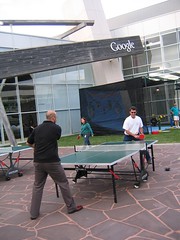 My showcase presentation of Google Maps mashups seemed to be well received. For those of you interested in what mashups I presented, here is the list:
WeatherBonk, Dartmaps, World Cup News Map, Where's Tim, Wikimapia, BeerHunter, If The Earth Were a Sandwich - Find the Opposite Tool (I had planned on also showing these but didn't get the chance since I was short of time): ShakinDave, EBay Real Estate, Alkemis Local
After the day's product announcements, showcase and breakout sessions Google held a great outdoor BBQ for the participants of the day. The sun finally made an appearance after the 3 days it had been hiding behind the Pacific cloud. A band played, table tennis and a ball-launch carnival game entertained while tables of great food, an ice tub of beer and ice cream station pleased. There was nothing held back from this day. Google put on a world class event. I had a great time taking part, sharing Google Maps Mania and meeting some great people.
Photos from the day are here:

Related from the day:
Luistxo from Tagzania's Flickr photos from the day..
Matt Savarino's Flickr photos from the Googleplex..
Gus from MiamiBeach411 talks about his experience (with photos)..
Blog Post: Where 2.0 Warmup
Flickr user 500Hats has 3 pics from the day here..
Monday, June 12, 2006
Google Geo Developer Day Post #3
 I'm live at the Googleplex blogging Google's Geo Developer Day...
2:00PM: Okay, so for those of you tuning into the Google Geo Developer via Google Maps Mania this is the stuff that really matters. A lot of Google Maps product announcements have just been made. Here is a brief summary of those announcements (I'll elaborate later):
- International Geocoding Support - Google Product Manager Thai Tran just announced geocoding support for the Google Maps API. It is now available for US, Canada, Japan, France, Italy, Germany and Spain -- Convert addresses to geographic coordinates! This is a HUGE announcement for the Google Maps community who today might be using external geocoding services. He pleaded with the geo developers in the room to "promise to cache your geocodes" so they can up the standard number of geocoding requests available. Check out more info at the Google Maps API page for more details.
- Google Earth KML to Google Maps - Cut and paste any Google Earth KML file to the Google Maps Search Bar and instantly map this information just like you would view it in Google Earth - An instant Google Maps mashup! Google Maps Product Manager Jessica Lee showed off some cool KML files loaded directly on Google Maps. Very cool! :)
- Google Maps for Enterprise - New licensing model starting at $10,000 per year allows companies to use the Google Maps API and marry it with data on your corporate intranet behind a protected firewall. This also entitles you to gain support from this service licensing fee. This is in additional option to the current Google Maps API.
- Other points: New Google Earth imagery now available for 1/3 of the world population, 1/5 of the planet is now covered with this new data (new imagery for every country) -- this data should be in Google Maps in a few weeks.
1:25PM: Google's top brass Eric Schmidt (CEO), Larry Page and Sergey Brin (co-founders) just provided open remarks followed by John Hanke and Michael Jones of the Google Earth teams. Eric, Larry and Sergey outlined the importance of Google Maps in the overall Google Search strategy. Cameras are all over the room, so this address and thoughts should be available on Google Video soon.. I'll be sure to point you to it later. Google Maps product announcements to come soon! :)
10AM: Just posting a short one here from the final hour before the Google Geo Developer Day begins. I'm in the front row of a large room. In front of me John Hanke is going through his talk and several laptop monitors are glowing around the room. At the front of the room two large screens show a series of really cool Google Earth flyovers, along with several maps mashups flashing up on the screen. Two plasmas to the left and right of the room show the brilliant colors of the Google logo. TV Cameras, sound mixing board - An appearance by Chief Executive Officer Eric Schmidt is also expected. The day promises to have some exciting Google Maps announcements, so be sure to check back periodically for the next several hours. I can tell you I'm pretty excited sitting in here watching this ready to take off!
Want to see where I am? View my "personal" Google Map! :)
Saturday, June 10, 2006
Here in San Francisco!
 I've arrived in San Francisco after an uneventful flight from Toronto. I'll be here over the weekend for the Google Geo Developer Day being held on Monday, so I thought it would be a good chance to enjoy a bit of holiday time as well! Tim Hibbard was nice enough to ship me one of his nifty GPS phones that shows where I am when we're out and about.. Where else? On a Google Map! :)
Friday, June 9, 2006
Google Mapping Top 10 US Colleges, Classifieds by zip code
 Top 10 Colleges +
Princeton Review Top 10 Colleges - Virender Ajmani adds to his impressive mashup collection by 'Google Mapping' the Princeton Review Top 10 Colleges based on the following:
- Academics
- Best Value
- Happiest Students
- Beautiful Campuses
- Party Colleges
- Where Students Always Study
- Where Students Never Study
- Toughest Colleges to get into
 +
+ Google Maps + Yahoo Geocoding + Microsofts Live Expo Beta - Here is a mashup that takes elements from the titans of the software and web world - Google's Maps, Yahoo!'s geocoder and Microsoft's new dynamic social listing service (Live Expo) and mashes it all together to create a great web app that lets you Google Map classifieds by your own local zip code! Be sure to check out Virender's local news, weather, restaurants, theaters and golf courses by zip code mashup as well!
Google Maps US/Canada Phone Book Mashups
Visually Mapped White Pages Mashup - GeoWhitePages has been completely revamped with a new user interface (it's really nice) and also sees the addition of census data to the info-windows. Here is the description from the site: "..GeoWhitePages.com provides a free people search service that displays its search results on a map. Instantly find friends and family by performing a Name or Phone search." (Works for the U.S. only)

 Phone Number Geolocator - Want to geographically locate the phone prefix (NPA-NXX) of a US or Canadian telephone number? Use this Google Maps based tool to perform the lookup and nifty gmaps pin marks the spot. This is a great little tool. [via ProgrammableWeb.com]
"Google Stalk" (Canada) - Plot people by Canadian Phone numbers.
Phone Number Geolocator - Want to geographically locate the phone prefix (NPA-NXX) of a US or Canadian telephone number? Use this Google Maps based tool to perform the lookup and nifty gmaps pin marks the spot. This is a great little tool. [via ProgrammableWeb.com]"Google Stalk" (Canada) - Plot people by Canadian Phone numbers.
Thursday, June 8, 2006
Blogger woes
Sorry to anyone who was attempting to view Google Maps Mania today - Blogger.com has been ailing for a few days now and has been limiting access to viewing (and posting). Sorry for the inconvenience. I'm hoping the good folks here at Blogger have things sorted out now.
Follow a live UPS delivery on Google Maps!
 This Monday I'll be speaking at the Google Geo Developer Day at the Google headquarters (aka "The Googleplex) in California. During this presentation I'll be showing some of the year's most interesting Google Maps mashups and applications to Google Maps/Earth geo-developers, as well as members of the press who will be in attendance. One of the apps that I plan on showing in this presentation is Where's Tim. Where's Tim tracks the current location of Tim Hibbard using a phone loaded with GPS software and Google Maps and Earth. When I mentioned this to Tim Hibbard, he decided to send me a phone pre-loaded with the software and a data plan from Nextel to make the presentation more interesting. That's not the cool part. He "forgot" to turn off phone as he packed it into the box and it's STILL ON reporting its position during its shipment.. Take a look! To see the journey so far, enter 6/7/2006 in the "Get History" field to the left of the map and you can plot everywhere it has been on to Google Maps or Earth. Battery life and data roaming once it crosses the Canadian border are all things that stand in the way of this tracking map continuing to be up to date, but until then it's pretty cool..
Do you Digg this?
Wednesday, June 7, 2006
Florida Google Maps Hurricane Mashup
 With the 2006 hurricane season now officially underway in the state of Florida a local newspaper is helping residents of this state to prepare for the potential of storms using Google Maps. The Sarasota Herald Tribune created IBISEYE.com, which although still in Beta, is a great all around mashup with a huge amount of data that includes every hurricane to hit Florida since 1851! Also available is a "risk estimator" that attempts to figure out how many buildings would be affected if any given storm were to hit the state of Florida today (this works for storms since 1960).
This Google Maps mashup can also be used when storms are approaching to gain live weather alerts for the gulf coast, as well as the ability to add "damage reports" to the map by zooming in to a property on a "neighborhoods" map. In the works are user-submitted image galleries, and geocoded AP news stories relating to hurricanes so they appear in relation to where the user is on the map. Charlie Szymanski, Online Producer for the Sarasota Herald Tribune, is the person that contacted me about this mashup and it is obvious that he and his team understand how Google Maps can be used in a news and media website.
Related:
How Google Maps is used in News & Media - Part 1
How Google Maps is used in News & Media - Part 2
More Hurricane and Storm Google Maps Mashups
Technorati Tags: [hurricane], [Florida], [Google Maps Mania], [Google Maps mashup], [mashup], [Google Maps]
Google Maps news and blog post roundup
Cyclists mash up Google maps (Google Maps Mania gets quoted)
Sydney Morning Herald TECH - Jun 6/06
Denver Post covers Google Maps TV Maps (Google Maps Mania gets quoted)
DenverPost.com - Jun 6/06
Google Spreadsheets and Mapping
All Points Blog - Jun 6/06
Wikimapiaplaceopedia
Webbys.World Blog - Jun 6/06
Map Mania
Forbes.com - Jun 5/06
Highlights from Google's Q&A with Investors
Clickz Blog - Jun 1/06
Google Earth Driving Traffic to Google Maps? Really?
All Points Blog - Jun 1/06
Google Maps: A Primer for Small Business
Small Business Computing - Jun 1/06
Quick Â’nÂ’ Clean
June issue of WIRED Magazine
The Shift from Making Mashups to Tools for Mashups
All Points Blog - May 30/06
Google puts everywhere in NZ on map
Stuff.co.nz - May 29/06
Google Earth Blog Presenting at Google Geo Developer Day
GEarthBlog.com - May 28/06
Belgian military sees no danger from Google's imagery
OgleEarth.com - May 28/06
Cheat Sheet: Mash-ups
Silicon.com - May 26/06
Mapping popularity contest, cont.
OgleEarth.com - May 25/06
City swallows first growth
Dr.Vino Blog - May 18/06
Tuesday, June 6, 2006
Berlin transit system + Google Maps = ÜBERBAHN
 "Guten Morgen Berlin - Actung, It's Uberbahn!" - This was the subject line of the email from Will over at OnNYTurf this morning as he informed me of the release of his Berlin Subway Map mashup coined: ÜBERBAHN. Just in time for the FIFA World Cup starting this Friday, Will has created a mashup of the S&U Bahns and MetroTram in Berlin, Germany. The mashup, in both German and English language has scaled down functionality as it launches in beta today but more features are on the way. Currently the mashup features 2 map types and 3 zoom levels for: S & U Bahns (which are like the subways) and Trams (known as MetroTram, they are only in the East). Some of the features that are coming soon include: More Zoom Levels, Address Search, Favorite Locations and Multiple Languages.
 :
:"..If you happen to be going to Berlin you will find this map immensely helpful. I could not find a clear street accurate map showing the Metro system while I was there. Heck, I could not even find a map that put the Trams on the same page as the Subway lines! (they are sort of different systems)." (Read More..)
Other new Google Maps mashups from Germany:
For more German Google Maps mashups, check out Google Karten Blog (The "German Google Maps Mania")
New Google Maps: NYC, Seattle, Oregon, DC, Missing Kids
 NYC Google Maps Restaurant Mashup - Here is a new NYC Google Maps mashup to add to the ever growing list. This map incorporates restaurants the developer has compiled or has eaten at and is sorted by name of restaurant, cuisine and neighborhood. Column sorting works as it does in Excel.
Seattle Department of Planning & Development uses Google Maps API - Google Maps has been used by Seattle.gov to create an Activity Locator. This tool allows you to plot on a Google Map where constructions, land use and demolition permits are currently issued, along with land use notices. It's a great way that a municipal government is leveraging the cost savings from Google Maps as a mapping application to serve a public purpose.
 Oregon Wine Board Google Maps its wineries - Here is a Google Maps mashup of all Oregon Wineries created by the Oregon Wine Board. When this mashup was created it actually allowed all the wineries to populate it using a back end tool that was developed. This ensures data integrity and improves the overall quality of the mashup. This is a great idea for a board or association to let its members participate in keeping the mashup current and up to date.
 Manhattan + San Francisco, Chicago, Boston etc.. - Want to put the size of Manhattan in perspective? Jason Kottke helps you do this by taking the Google Map of the island city and putting it next to Chicago, San Francisco and other places he has lived. The result lets you appreciate its size in comparison with another city. Very interesting. [via]
Other new maps:
Google Maps + National Center for Missing and Exploited Children
Google Maps + Washington Metro = MetroMapr
Monday, June 5, 2006
Australian & New Zealand Google Maps mashup roundup!
On your bike with Australian Google Maps Mashup: Bikely - Bikely is a new Google Maps mashup that helps you to find and share the best cycling routes around Australia. Just select a route from the list on the main page, and a Google Map illustrates the route for you. You can share your own bike route by joining Bikely and mapping out a route that you'd like to show off to others. [via]

New Zealand Google Maps street and placenames - Mayo is a simple Google Maps placename explorer for the country of New Zealand that is taking full advantage of the introduction of street mapping. Entering keywords like street names, city and village names will narrow your search only to New Zealand Google Maps content. Results are text listed, as well as pinned on the map. An example search might be: "Hobson St" which lists all occurrences of this street name in New Zealand. I especially like what takes place when you "hide" the search result screen. Convenient page linking and email linking is also built in.

AUS-eMaps Google Maps - This new mapping application based on the Google Maps API will help you perform placename lookups in Australia, enhance your viewing of Google Maps satellite images and also let you build your own free maps (both Google and non-Google topographic).

It has been 19 days since street level mapping arrived for the Australian and New Zealand landscape in Google Maps. The number of new mapping applications created using the Google Maps API and marrying Australian based information has been slow to get off the mark. This surprises me since the Google Maps application is Australian born. First, let me offer up my thoughts on this:
Aussies and Kiwis may not know how easy this is to do! :) In short, here is what you can do to start mashing up data and creating your own online Australian or New Zealand Google Maps mashup... To take the "programming route" and get your hands dirty with javascript and code, head to the Google Maps API page and take a read through the documentation that is available. The instructions are extremely easy to follow and even folks with no previous javascript knowledge can use examples they provide to start creating a Google Map of your own. I know there are armies of indie coders out there that have the knowledge to pick up the API, hook onto a database and start mashing (so what are you waiting for?!:)). In addition to the official Google page, this link can supplement the Google Maps API docs as well. You can also clone Google Maps apps that have already been built on the Ning platform and apply them to the Australian or New Zealand webscape.
If raw code isn't your thing but you have the mapping itch, head over to one of the many Do-It-Yourself Google Maps sites like Tagzania, CommunityWalk or Wayfaring to start building a Google Map of Aussie and Kiwi information using the great user interfaces provided. If you have a list of information in an Excel file or even scratched down on paper, you can instantly add labels, photos and information to each of these points and have a Google Map mashup for this topic going in no time. Google Maps Mania and the many mashup examples and resource links can help you in this process. Good luck, and be sure to drop me a line when you have your mapping creation built!
New Zealand Google Maps street and placenames - Mayo is a simple Google Maps placename explorer for the country of New Zealand that is taking full advantage of the introduction of street mapping. Entering keywords like street names, city and village names will narrow your search only to New Zealand Google Maps content. Results are text listed, as well as pinned on the map. An example search might be: "Hobson St" which lists all occurrences of this street name in New Zealand. I especially like what takes place when you "hide" the search result screen. Convenient page linking and email linking is also built in.
AUS-eMaps Google Maps - This new mapping application based on the Google Maps API will help you perform placename lookups in Australia, enhance your viewing of Google Maps satellite images and also let you build your own free maps (both Google and non-Google topographic).
It has been 19 days since street level mapping arrived for the Australian and New Zealand landscape in Google Maps. The number of new mapping applications created using the Google Maps API and marrying Australian based information has been slow to get off the mark. This surprises me since the Google Maps application is Australian born. First, let me offer up my thoughts on this:
Aussies and Kiwis may not know how easy this is to do! :) In short, here is what you can do to start mashing up data and creating your own online Australian or New Zealand Google Maps mashup... To take the "programming route" and get your hands dirty with javascript and code, head to the Google Maps API page and take a read through the documentation that is available. The instructions are extremely easy to follow and even folks with no previous javascript knowledge can use examples they provide to start creating a Google Map of your own. I know there are armies of indie coders out there that have the knowledge to pick up the API, hook onto a database and start mashing (so what are you waiting for?!:)). In addition to the official Google page, this link can supplement the Google Maps API docs as well. You can also clone Google Maps apps that have already been built on the Ning platform and apply them to the Australian or New Zealand webscape.
If raw code isn't your thing but you have the mapping itch, head over to one of the many Do-It-Yourself Google Maps sites like Tagzania, CommunityWalk or Wayfaring to start building a Google Map of Aussie and Kiwi information using the great user interfaces provided. If you have a list of information in an Excel file or even scratched down on paper, you can instantly add labels, photos and information to each of these points and have a Google Map mashup for this topic going in no time. Google Maps Mania and the many mashup examples and resource links can help you in this process. Good luck, and be sure to drop me a line when you have your mapping creation built!
Put a lense on Google Maps with IDELIX
 Here is a very cool new viewing tool that adds another perspective to your Google Maps viewing experience. Maps by IDELIX offers a Pliable Display Technology (PDT) lense view concept by allowing you to magnify an a specific area of the Google Map you are viewing. This eliminates some of that repetitive zooming and panning you might do, while retaining the surrounding context. You can toggle the overall map to satellite or street level, then switch the lens view to the opposite map type to create a really neat way to look around Google Maps.
Maps by IDELIX also has some neat features: A directions tool, with an example here, shows what you would see if you were going from your New York City hotel to a ball game. If you're looking for a place to eat nearby the lens viewer creates a spyglass effect as you zoom into various locations but keep your overall zoom level on the map out. Here is a cool view of the Statue of Liberty with satellite view on, while the rest of the city shows the street map view. Maps by IDELIX offers viewing on Google Maps as well as Windows Live Local, Yahoo! Local Maps and search results can be compared across all mapping providers.
 Here is more from IDELIX about this app: "..Taking experience gained through working on GIS applications for organizations like the National Geospatial-Intelligence Agency, we've now applied our patented Pliable Display Technology in an AJAX environment, facilitating advanced visualization capabilities in a thin client. Maps by IDELIX will continue to grow in functionality based on user input, with new business models developing as we follow our technology and product roadmaps."
Sunday, June 4, 2006
France Google Maps Mashup Roundup
Our French correspondent Renaud Euvrard is back with this week's France Google Maps Mashup Roundup. This is Renaud's second post. Check out his last post here, which has a list of all known Google Maps mashups from France:
You are looking for...
 ...A bookshop with the lastest book from O' Reilly which you wish to buy? With O' Reilly, where to find... it is easy to enter your postal code and ISBN code of the book that you to seek, and the maps indicate the bookshops closest to you with an approximate rate to the availabilities.
 ...The lastest news... concerning your city? Actu1clic.info: The current events of your city in 1 click offers you the last current events (from Google News or Yahoo News) of your city on one click! Is your city present? You can add it on maps and the system will seek the lastest news automatically. A simple but effective idea! You can also add any RSS feed on the map or add the weather.
Sights ... on Google Maps? - geo-trotter.com: to visit Earth with Google Maps is a directory of the satellite sights of Google Maps of France. It includes the most beautiful villages of France, monuments, circuits of F1, or stadiums of the Soccer World cup 2006 in Germany... there is a beautiful journey here without leaving your office.
 The access point wifi of the Fon network? - Fon Maps indexes the wifi access points of FON provided by Foneros. "FON brings together all the users of WiFi who share part of their wireless Internet connection. FON gather Foneros which set up a hotspot or access point (each Fonero does not become access point FON, once its activated router) by providing part of their bandwidth. Each new Fonero, while contributing a little its band-width makes it possible all other Foneros to reach a network increasingly larger and denser, everywhere in the world."
Fon is a Spanish project which is developing everywhere in Europe.
One more: Guide Des Locations Saisonnieres [via]
You are looking for...
...A bookshop with the lastest book from O' Reilly which you wish to buy? With O' Reilly, where to find... it is easy to enter your postal code and ISBN code of the book that you to seek, and the maps indicate the bookshops closest to you with an approximate rate to the availabilities....The lastest news... concerning your city? Actu1clic.info: The current events of your city in 1 click offers you the last current events (from Google News or Yahoo News) of your city on one click! Is your city present? You can add it on maps and the system will seek the lastest news automatically. A simple but effective idea! You can also add any RSS feed on the map or add the weather.Sights ... on Google Maps?
- geo-trotter.com: to visit Earth with Google Maps is a directory of the satellite sights of Google Maps of France. It includes the most beautiful villages of France, monuments, circuits of F1, or stadiums of the Soccer World cup 2006 in Germany... there is a beautiful journey here without leaving your office.The access point wifi of the Fon network? - Fon Maps indexes the wifi access points of FON provided by Foneros. "FON brings together all the users of WiFi who share part of their wireless Internet connection. FON gather Foneros which set up a hotspot or access point (each Fonero does not become access point FON, once its activated router) by providing part of their bandwidth. Each new Fonero, while contributing a little its band-width makes it possible all other Foneros to reach a network increasingly larger and denser, everywhere in the world."Fon is a Spanish project which is developing everywhere in Europe.
One more: Guide Des Locations Saisonnieres [via]
Live Google Maps flight tracker is a success!
Check out yesterday's post about Indiana's "Captain Dan" and take a look at his return journey flight that is happening right now on a Google Maps page he created using the Google Maps API:

 ..If you tune in after Dan has landed, take a look at the Google Map page that has the journey there, and back. Looks like this Google Maps flight tracker was a success. I'll ask that Dan posts some comments on this post to let us know how things went! :)
For more real person, real time mashups, check this April 26th post..
..If you tune in after Dan has landed, take a look at the Google Map page that has the journey there, and back. Looks like this Google Maps flight tracker was a success. I'll ask that Dan posts some comments on this post to let us know how things went! :)For more real person, real time mashups, check this April 26th post..
Saturday, June 3, 2006
Contest for the best Spanish Google Maps mashup
 Google Maps Mania Spain Correspondent Luistxo from Tagzania reports on some new and interesting Google Maps mashups and news from that country:
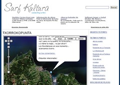
 Ojobuscador, Spanish search engine watchdog, with the collaboration of Google España itself, has organised a contest to award the best Spanish Google Maps mashup. Several projects have shown up there already. Among them, a new interesting mashup, the Surf Atlas, an attempt to map surfing spots tied to the Surfkultura site. Other participants include mashups already mentioned at this blogs like the Spaniards.es map, Panoramio or Tagzania. However, there's plenty of time to apply with your own mashup, or even perhaps conceive and create one, as the deadline for submissions ends on September 15th. The jury will award the prize (travel to the Googleplex in Mountain View, California) on October the 1st.
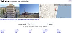 Other novelties in Spain: Vivirama, which was previously a mashup of real state listings (from Loquo Barcelona, the Spanish equivalent of Craigslist), has evolved to be a place where housing listings can be made by users directly in any city of the world. Xavi Caballe has used the Geonames Webservice to geolocate world cities.
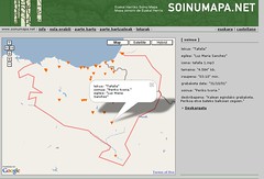 A Basque mashup (bilingual, Basque, Spanish), Soinumapa a sound map of the Basque Country. Curious audio files recorded on the streets and fields of this European corner... Some kind of art experiment, it seems. But they should update to the new version of the Google Maps API, cause it may become outdated soon.
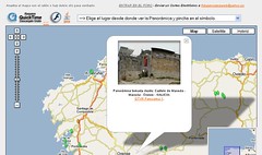 Fotopanorama is a series of 360 degree pictures (they rotate, if you have Quicktime installed), taken mostly in the region of Galicia, and placed over a Google map. The mashup
is related to the Digito.es, a photography stock website.
Friday, June 2, 2006
Track a live flight on Google Maps this Sunday
Check this site on Sunday at 10 AM EDT to catch "Captain Dan" in his one hour flight to test his live, real-time Google Maps flight tracking system. Here is an excerpt from his blog:
"..I've rigged up a real-time flight tracking system using a GPS receiver, my PowerBook, Google Maps, and liberal quantities of tape and string."

Dan had originally hoped to fly from Indianapolis to Saginaw Michigan, but instead will take a short one hour flight within Indiana, due to some bad weather. It should be interesting to watch. His departure time will be 10AM - check here to reference the local time in Dan's location and here to track the live flight take off. Switch over to this page to watch his journey home. Good Luck Dan!
"..I've rigged up a real-time flight tracking system using a GPS receiver, my PowerBook, Google Maps, and liberal quantities of tape and string."
Dan had originally hoped to fly from Indianapolis to Saginaw Michigan, but instead will take a short one hour flight within Indiana, due to some bad weather. It should be interesting to watch. His departure time will be 10AM - check here to reference the local time in Dan's location and here to track the live flight take off. Switch over to this page to watch his journey home. Good Luck Dan!
Thursday, June 1, 2006
New Google Maps mashups from 6 countries
 Moscow, Russia Photo Map - Here is what might be the first known Russian Google Maps API implementation. It features several pins scattered across the city of Moscow with beautiful photos of various structural and historical locations. It also showcases the newly released street level data for this area of Russia. [via]
 Exploring the Dutch coast - This Dutch website integrates Google Maps to point tourists to various beach spots along the coast. Each pin brings you to a separate page where local activities and events are outlined. [via]
 Mapping Swiss road fatalities - Aggregated from local newspapers to a Wordpress blog this site in Switzerland visually maps victims of traffic accidents. It uses a geo-plugin to add coordinates to the posts and another plugin to show each post as a marker.
 Video and Audio Guides in Italy - This site presents English language video and audio guides that are mapped by location. Files are taken from FreeAudioGuide.com.
 Tanawing Pinoy maps the Philippines - Tanawing Pinoy brings you Filipino sites from Google Maps. In the absence of street and road mapping here, this blog helps you to identify what various locations are from satellite maps of the country. Elsewhere folks in the Philippines are eagerly awaiting high res satellite imagery for Manila.
 India Malayalee Matrimony Mashup - Virender Ajmani has created a mashup for would-be Assamese, Bengali, Gujarati, Hindi, Kannada, Malayalee, Oriya, Marwadi, Marathi, Parsi, Punjabi, Sindhi, Telugu, Tamil, Urdu brides and grooms from around the world.
Pakistan - Blog post describes Hi-Res images for Karachi and Islamabad
Subscribe to:
Posts (Atom)
Popular Posts
-
Here again is another (the 11th) roundup of the latest Google Maps Creation (and Viewing) Tools and Resources. I've assemble these list...
-
+ = Google Maps Mashup Roundup Part 1 (of 2) ( See Part 2 here.. ) Google Maps is powering the Web 2.0 craze here in Canada . It is bringi...
-
Boston.com has used the previously mentioned Atlas Google Maps tool to create a map of the recent Mooninite scare in Boston . You might re...
-
Massachusetts contributions to gubernatorial candidates - Faneuil Media dropped by to tell me about a very interesting and eye-opening Goog...
-
Sacramento Crime Tracker - This next mashup is a great example of how media can use Google Maps to display information for those in the com...


