![](https://blogger.googleusercontent.com/img/b/R29vZ2xl/AVvXsEjVuVFF97sprFV2UrPTsNu3ce_gAaVAzlH_3_FJYfVpwGbFsrpeGCLoE8_OjqzEVKUW__RF5ikClaZeIn4kAY9VA5EAHkAZhDRMWOvilCNDLE_yb6w3HAAWUqJezTUIY9G8tbf9YJzBL1VR/s400/earth.jpg)
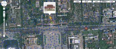
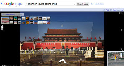
When you drag pegman over Google Maps blue dots will appear on the map where user contributed photographs are available. You can still tell where Street View is working because Street View availability is shown with blue lines.
If you drop Pegman on a blue dot you will then be able to view the photogrpahs at this location with the Google Maps photo browser.
![](https://blogger.googleusercontent.com/img/b/R29vZ2xl/AVvXsEjrydD7rtCVXNgCbeUOJRL5UCT1HdQH397gr-C6TCdpaXreP80baZr-KP4f_FblKbsTpOQo_mCLSXjY70r1DhA9IjShG2MJ1JsiFMxaZaeUTImrjLir4TV3d1QURPUsLS-4qr4g1OiQ4pOr/s400/earth.jpg)
Via: Google LatLong
________________
0 comments:
Post a Comment