Blog Archive

Monday, April 30, 2012

A Google Maps New York Special


Uncivil Servants is a crowd-sourced Google Map of illegal parking incidents by New York city employees.

Apparently New York city civil servants  have been rampantly abusing parking permits. Uncivil Servants wants to to eliminate this parking permit abuse. Anyone can use the site to post photos of vehicles abusing parking permits and the reports will be added to the map.


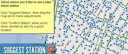
NYC DOT and Alta Bicycle Share want to establish a bike share system in New York City.

The New York City Bike Share Map is a Google Map which New Yorkers can use to suggest where bike share stations should be located.


The Jackson Heights Neighborhood Transportation Study is a Google Map of data collected by DOT as part of a Jackson Heights study.

The map shows average traffic speeds on Jackson Height's roads, pedestrian volumes and the locations of vehicle accidents in Jackson Heights.

What Your Phone Company Knows About You


Cal Flyn, a journalist for The Daily Telegraph, has used Google Maps to map one year of her movements. Using Freedom of Information laws Cal obtained all the location data held about her by her mobile phone company.

Digital surveillance: what my phone records say about me, animates through the year's location data showing Cal's to and from work, visiting her parents in Scotland and everywhere else she visited.

The Daily Telegraph article is obviously inspired by German Green party politician, Malte Spit's Google Map, published in the German newspaper Zeit last year. Verräterisches Handy uses Google Maps to animate Spitz' movements over six months.

 The amount of data collected by Spit's and Flyn's phone companies is amazing (some would say frightening). Spit's location was logged 35,000 times in a six month period. Flyn's map shows her whereabouts for a whole year, with only two days missing (when on vacation and she had left her phone charger at home).

Sunday, April 29, 2012

Maps Cube - The Google Maps Game


Google Maps Cube, Google's long awaited Google Maps game, has now been released. In the game you have to navigate a ball on a 3d Google Maps cube, avoiding the 3d buildings and other obstructions, by rotating the cube.

The object of the game is to roll a small ball through a city on Google Maps and reach the indicated destination. If you manage to steer the ball to the correct destination your time is displayed and you can proceed to the next level.

The game has a few nice features. For example, in London you can use the Underground subway lines to move from one part of the map to another. The game also becomes a bit more interesting as you progress through the game, the later levels feature some indoor maps and the final level involves some tricky maps created by mixing up the map tiles from different cities.

The game seems to require the Chrome browser.

The Google Maps of the Week


This week I loved TweetedTrips, an application that lets you create a journey map of your geotagged Twitter messages in a matter of seconds.

If you want a mapped journey of a vacation or trip you just need to send some Twitter messages from your phone and they will automatically appear on your TweetedTrip map. You don't even have to use your own account. You can enter any user name Into TweetedTrips and view a Google Map of the user's geotagged movements.


The real big theme this week however was real-time live transit maps.

 Stadtbahn Tracker Freiburg is a real-time map of tram cabs, buses and local trains in Freiburg, Germany.

MTA Bus Time is a Google Map that shows the live position of buses on New York's bus system. Currently the map tracks all bus routes in Staten Island and will be rolled out to other NYC boroughs, with expected completion in 2013.

The DC Circulator Map is a live real-time map of the DC Circulator bus system in Washington, DC. The map shows the system's bus routes and the bus stops on each route. 

Saturday, April 28, 2012

Photoshop Tile Cutter for Google Maps


If you want to create your own map tiles for the Google Maps API you can now use Photoshop thanks to Bramus Van Damme's Photoshop Google Maps Tile Cutter Script.

With the script you can automatically cut a very large image in Photoshop into tiles which you can immediately use with the Google Maps API.

The script is available for download on Github. There is also an example map on Github (screenshot above) with tiles created using the Photoshop Google Maps Tile Cutter Script.

Danish Data Journalism Award


Google, The Guardian and the Danish newspaper Information have announced the winner of the Danish data journalism competition, Nyhedshacker 2012.

The winning project, Doctors for Sale was created by Anders Pedersen. Doctors for Sale is a Google Map, created with Fusion Tables, that shows all the Danish doctors who are sponsored by the medical industry. The information is designed to inform patients about which of their local doctors might be prescribing drugs based on their sponsorship rather than based on strict medical reasons or prescribing the cheapest drugs available.

Anders Pedersen's prize for winning the competition is €2,500 and a one month secondment with the Guardian newspaper in London working with the paper's Datablog team.

Hat-tip: microformats.dk

Friday, April 27, 2012


The DC Circulator Map is a live real-time map of the DC Circulator bus system in Washington, DC.

The map shows the system's bus routes and the bus stops on each route. It is possible to click on a bus stop marker and find out when the next bus is due. When you click on a bus stop's marker you can also find out about nearby points of interest, including how far they are from the stop and in which direction.

The map also shows in real-time the location of all the system's buses. The bus map markers are color-coded to show which route they belong to and include arrows to show the direction of travel.

University Campuses on Google Maps


The University of Arkansas Campus Map is a good example of how the Google Maps API can be used to create a mapped guide to a university campus.

The map includes all the useful features that you would expect from a campus map; you can search for rooms and buildings, find dining areas, view the location of computer rooms, see where parking is available and view bus routes through the campus. The map also includes walking directions, so that students and staff can enter a starting point and a destination and view walking directions on the map.

Another really nice feature is the labelling of buildings, which becomes more detailed the more you zoom in on the map. When the map is zoomed out the building labels are abbreviated to fit on the map but as you zoom in give the full name of a building or department.

If you want to create something similar with your own maps you can use the MapLabel Utility Library. Labels created with the utility are dynamically rendered on Google Maps using Canvas 2D. Developers can define the font size, the font face, color and alignment of the labels. The library also includes maxZoom and minZoom controls which let you define at what zoom levels labels should be visible.

Thursday, April 26, 2012

Freiburg's Buses Live on Google Maps


Stadtbahn Tracker Freiburg is the second live transit tracking map featured on Google Maps Mania this week (the first was MTA Bus Time). In fact live real-time tracking maps have become so common that it is easy to became rather blasé about them and forget just how amazing it is to track in real-time whole transit networks on a Google Map.

Stadtbahn Tracker Freiburg is a live map of of all tram cabs, buses and local trains in Freiburg, Germany. The developer of this map has taken a novel approach to how he fetches the real-time data of the vehicles. The map loads all departure/arrival times in advance during startup. These times are then updated every 5-10 minutes or so. The calculation of the exact vehicle positions is therefore completed on the client side by JavaScript.

Another interesting feature of this map is that you can query the map by time. For example, you can view the city's transit network during the morning rush hour by attaching a time stamp to the URL, for example http://tracker.patrickbrosi.de/freiburg/?time=1335419192000

Create a Personal Journey Map


Go Pro Travelling lets you create a Google Map of any trip whether it be a walking tour, a bicycle ride or a vacation. Users can add information and photographs to each stage of the trip and create a great mapped record of their journey.

The finished map includes numbered map markers showing the chronology of the trip. If you click on a numbered marker you can view the text and photographic entries for that stage of the journey. The application automatically displays how far has been travelled since the last stage and you can even indicate what mode of travel was taken.

Links to Twitter and Facebook mean it is very easy to share created trip maps with friends and friends can even leave comments on the map itself.

Wednesday, April 25, 2012

New 45° Imagery for Google Maps


Google Maps has unveiled new 45° oblique imagery for 8 international locations and 11 U.S. locations.

Avignon in France and Rotterdam in the Netherlands are amongst the international locations to get 45° imagery for the first time, whilst Miami is one of the American cities to be featured.

The full list of new locations is:

International: Avignon, France; Reus, Spain; Rotterdam, Netherlands; L'Alcudia, Spain; Gandia, Spain; Sueca, Spain; Burgos, Spain; Los Palacios Y Villafranca, Spain

US: Albany, GA; Omaha, NE; Baytown, TX; Miami, FL; Amarillo, TX; Monroe, LA; Manchester, NH; Alexandria, LA; Rapid City, SD; Loudon, TN; Farmington, NM

You can view all the locations with oblique imagery on this Google Map.

You can check out my personal picks of the best 45° views in this Slideshow Map.

Via: Google Lat Long

Introducing Google Maps Photo Tours


Google has introduced an amazing new Photo Tours feature on Google Maps. When you use the WebGL version of Google Maps (try it in Chrome) you can view some amazing Photo Tours of famous locations around the world.

Photo Tours are available for more than 15,000 popular sites around the world, try St. Mark’s Basilica in Italy or the Half Dome in Yosemite. When available a link to the photo tour will appear in the left side-panel.  Alternatively, if you’re browsing the map and click on the label for a particular landmark, the info window that appears will indicate if a photo tour is available.

This map  shows the locations of all the currently available Photo Tours.

Via: Google Lat Long

Greek Coupons and Deals on Google Maps


Deals on Map is a nicely designed Greek coupons map and if anyone deserves to be able to find cheap deals at the moment it's the citizens of Greece.

The site uses Google Maps to show users the nearest deals and coupons nearby. The map can be searched by location and by type of deal. Links in the map sidebar allow the results displayed on the map to be filtered by category, for example hotels, food, beauty etc.

When you click on a deal's marker on the map the offer is loaded into the right-hand sidebar. To claim a deal or coupon you just need to click on the sidebar image for the deal.

Middle Earth on Google Maps


Middle Earth Map is an interactive map of J.R.R. Tolkien’s Middle Earth. This one doesn't use the Google Maps API but the map is beautifully designed and it includes a nifty little feature to change the map labels from English to Elvish.


If your Spanish is better than your Elvish then you might want to check out La Tierra Media. This Google Map of Middle Earth includes a sidebar with links to zoom and pan the map to locations in Middle-Earth on the map (in Spanish).


If your English is better than your Spanish and Elvish then you need the Lord of the Rings - Middle Earth Map. This map also includes handy sidebar links to find locations on the map.


The Interactive Map of Middle Earth uses the Google Maps API to create a simple interactive map of Middle Earth. There aren't any map markers or guides to the locations on the map but you can pan the map around to explore Tolkein's fantasy world.

And Finally -you can always use Google Maps walking directions to get directions to Mordor, although do remember that One Does not Simply Walk into Mordor.

Tuesday, April 24, 2012

A Supercharged Google Maps Rocket Ride


Chemin Vert is a simulated rocket ride across five continents using Google Maps Street View images. It takes you on a bone shattering journey at close to a 1000 mph using Street View imagery from around the world.

There are three versions of Chemin Vert, one in normal resolution, a high resolution version and lastly a Vimeo video. To view either of the first two versions you need a browser that supports WebGL (such as Chrome). After either of the first two versions load you just need to sit back as Chemin Vert animates through thousands of Street View images, taking you on a virtual journey across five different continents.

Hat-tip: Street View Funny

New York Buses Live on Google Maps


MTA Bus Time is a Google Map that shows the live position of buses on New York's bus system. Currently the map tracks all bus routes in Staten Island and will be rolled out to other NYC boroughs, with expected completion in 2013.

It is possible to search the map by intersection, bus route or individual bus stop. If you click on an individual bus you can view its next three stops. If you have a mobile phone you can use the QR codes posted on bus-stops to find out when your next bus is due.

TwitTrips on Google Maps


TweetedTrips allows tweeting travellers to create and share an interactive map of their tweets, complete with their photos and an 'Indiana Jones-style' polyline of the journey.

Creating a Google Map of your journey couldn't be easier. All you really need to do is enter your Twitter user name. TweetedTrips then automatically creates a map of your geolocated Tweets. If some of your Twitter messages aren't geo-located you can manually add them to the map.

Once you save and publish your map you can share the map page with your friends and followers. Any future located tweets will automatically be added to your map so that your friends can follow your progress on your Tweeted Trip. 

Monday, April 23, 2012

Cannabis Dispensaries on Google Maps


Leafly is a marijuana dispensary search engine and strain reviewer.

The site uses Google Maps to help users (ha!) find their nearest marijuana dispensaries and cannabis collectives.The map includes options to filter the results by dispensaries that accept credit cards, those that deliver and those with an online menu.

If you click through you can read detailed reviews about the individual dispensaries, including strains on offer and customer reviews.

Also See

Germans Living Near Nuclear Plants


Last year I reviewed Zeit-Online's American Nuclear Power Plants Map. A Google Map that shows how many Americans live near nuclear power plants. Zeit-Online has also created a similar map for its German readers.

The German Nuclear Power Plants Map shows how many people live close to German nuclear power plants. The map includes a distance slider tool that lets you visualise how many people live within different distances of a nuclear power plant.

After radioactive material escaped from Japan's Fukushima power plant, everyone within 30 kilometres of the plant was evacuated. The Zeir-Online map shows that nearly 10 million Germans live within 30km of a nuclear power plant.

Revisit Film Scenes with Google Maps


Allen Fuqua has been travelling around the world recreating scenes from popular films. The photographs of these scene recreations can be found on his website Movie Mimic.

Movie Mimic shows Allen's photographs of locations used in films next to a still of the same scene from the actual film. Each photo is accompanied by a small Google Map that shows the location where the scene was shot.

There is also a Picassa Web Album Google Map of all the Movie Mimic photographs located on one map of the world.

Sunday, April 22, 2012

Digging for Earth Day


To celebrate Earth Day Google has released an Earth Day Resource Page. The page includes a link to a Google Map where you can find your local community gardens.

The map will help you find a space in a community garden or discover farmers' markets and local farms in your area. The Earth Day Resource Page also includes links to get discounted seeds for flowers, herbs, and vegetables and to connect with the gardening community on Google+.

Via: Google Lat Long

French Election Results Live on Google Maps


From 8pm this evening (French time) you will be able to watch the results of the French presidential election live on a Google Map.

The Google Politics and Elections website features a Google Map that will display the results for each electoral department as soon as the results are announced. The first official results will be released after the last stations close at 8pm.

 The map can even be added to any website using, this iframe code:

<iframe frameborder="0" width="788" height="540" src="http://fr2012.election-maps.appspot.com/results/embed?hl=fr"></iframe>

Via: The Official Google France Blog

The Google Maps of the Week


If you are planning your vacation then you should check Weather Hopper to find out what you should pack. Weather Hopper is a great Google Map that can tell you what the weather is normally like for any month anywhere in the world.

The weather itself is displayed in a small information window which automatically appears over your searched location. You can select what type of weather information you wish to view from the side-panel, including average usual temperature, precipitation, relative humidity and wind. 


Weather Sentiment Prediction is a clever Google Maps based application that can tell you how people feel about the weather at any location.

You can select a location on the application by dragging the map marker and adjusting the radius of the search area. Once you hit the 'search' button the application begins to analyse Tweets from that area which mention the weather. Each message is machine analysed to determine whether it is a positive or negative response to the weather.


This weekend's Formula 1 Grand Prix in Bahrain has been very controversial and should probably have never been held. However with about half an hour to go before the race (as I write) it looks like the race will go ahead.

Lusob.com has created a Google Map that will hopefully track the race in real-time on Google Maps. The F1 Live Timing Map is currently showing a demo race using imagined data. The map shows the cars moving around the Bahrain Formula 1 track on Google Maps satellite view.

Saturday, April 21, 2012

Free Stuff Advertised on Google Maps


If you have any unwanted items that you would like to give away then you can use Curb Side Goodies to advertise their availability.

Using Curb Side Goodies you can pin your unwanted items to a Google Map and then just leave them out in your garden or sidewalk and wait for someone to come and pick them up. Adding an item to the map simply involves right-clicking on your location on the map and describing your item.

To avoid random people visiting your house every day for the next three years all pins added to the map are removed after a 24 hour period.

Kickstart Art on Google Maps


geocodedArt has been busy mapping the world's fine art paintings for the last few years. Their website provides a great way to explore some of the world's great artistic masterpieces geographically with a Google Map.

geocodedArt now want to develop a smartphone application that will allow users to find and explore paintings of the landscape around them. The app will allow users to stand in the spot that inspired a masterpiece painting, and study the painting at the same time; to fully appreciate how the atmosphere has been captured in the art.

To help raise the funds to develop the app geocodedArt has started a Kickstarter campaign. The campaign is trying to raise $7,750. Supporters of the app can pledge from as little as $5 dollars to the campaign.

Friday, April 20, 2012

Bored of Zombie Maps. Here's Count Dracula!


Frankly I'm getting a bit bored of the current trend for Zombie Maps. On the 100th anniversary of the death of Bram Stoker what we need are some Dracula maps.

Thankfully ikiMap have stepped out of the shadows and created two Bram Stoker related maps. The Map of Bram Stoker Facts is a Google Map exploring the life of the Dublin born author.  

Bram Stoker's Dracula: The Map is a map plotting some of the important episodes in Bram Stoker's Gothic novel Dracula. The map uses suitably blood red styled OpenStreetMap tiles. If that doesn't whet your appetite for blood then you can also visit Dracula's Castle itself on Google Maps with Google Street View.


The Civic Crowd is a Google Maps based application mapping amazing citizen-powered initiatives and ideas in the UK.

Users of the map can search for initiatives on the map by location and by type of project, for example, education, enterprise, housing etc. Projects are displayed on the map by categorised map markers and it is possible to click-through to read more details about each project.

Users can 'Appreciate' individual projects or ideas to show support for an initiative. It is also possible to 'Volunteer to Support' a project and specify the type of support you offer from within your personal profile.

If you know of a project that hasn't yet been mapped it is possible to add it by completing a short form.

Friday Fun with Google Maps

Four Seasons in One Day

I came across this satellite view on Google Maps this week. You can clearly see that some of the images have been captured at different times. I think the effect is rather nice.


One of my favourite maps from the last few months is the Nature Valley Trail View. Nature Valley Trail View provides custom Street View tours of nature trails. This morning I noticed that the site has expanded its coverage from the Grand Canyon to also include a number of virtual trail tours in Yellowstone Park and the Great Smokies.


Google Sightseeing has been busy finding some of the great views in the new Israel and Ukraine Street View images. This image shows the World Heritage site, Kiev's Monastery of the Caves.

Thursday, April 19, 2012

Street View Arrives in Israel


Wailing Wall

Street View imagery is now available on Google Maps in Israel. The imagery is available in Jerusalem, Haifa and Tel Aviv and also in a few universities and museums dotted around the country.

If you haven't got time to check out all the new Israeli Street View you can cheat by taking a quick tour of Mini Israel, a miniature park located near Latrun, Israel in the Ayalon Valley, which also now has Street View imagery.


Church of Gethsemane

A number of cities in Ukraine also now have Street View (I think these are new). The cities include Kiev, Donetsk, Kharkiv, Odessa and L'viv.


Annunciation Cathedral, Kharkiv

Capital Bikeshare on Google Maps


The Capital Bikeshare Tracker is a Google Map that displays the locations of the 140 bike stations of the Washington, D.C. Capital Bikeshare.

The map uses dynamic map markers to show the current availability of bikes and dock spaces at each bike station. If you click on a marker you can get the exact number of available bikes and free dock spaces.

It is also possible to click through on each bike station to view the usage patterns of that station. Each station can be searched to view bike and dock space availability over different periods of time.

Also See

Montreal's BIXI - a map of Montreal's bike stations and current bike availability
Brisbane CityCycle - Brisbane's CityCycle bike stations and available bikes
Dublin Bikes -Dublin's bike stations and available bikes
Paris Velib - Paris' bike stations and available bikes
CityMapper London - London route planner that also shows you how many bikes are available at your nearest bike station.

Austrian Google Maps Round-Up


Teleschirm is an Austrian website that wants to turn the tables on the pervasive users of CCTV by mapping where video surveillance is being used in public spaces. The site allows anyone to take a photo of a CCTV camera and enter its location on an OpenStreetMap or a Google Map.

Currently Teleschirm has active maps for all the major Austrian towns and cities. As well as the map view it is possible to view a list and photographs of the latest CCTV cameras to be posted to Teleschirm.


Öffliner is a free iPhone application that provides route planning on the Linz AG public transit network. Just enter a departure station and your destination and the application will show you the best routes and times available for your journey.

AustroZoom.at wants to be your one stop map for Austria. The application uses Google Maps to provide access to over 522,000 Austrian business locations, localised weather information, route planning and much more.

Fruchtfliege has created a number of Google Maps showing the location of different types of fruit trees in and around Vienna. In addition to the Google Maps the site features recipes and information about the different types of fruit.

Wednesday, April 18, 2012

U.S. Renewable Energy on Google Maps


The National Renewable Energy Laboratory has created a series of Google Maps related to renewable energy in the U.S..

The maps help to visualise a number of renewable energy data sets that show the potential for renewable energy in the U.S.. The maps include solar power and wind power guides, alternative fueling stations, geothermal resources and many more.

Hat-tip: Visualising Urban Futures and Street View Funny

Rain Forest Street View Out Now


Google has today released amazing Street View imagery of the Amazon River in Brazil.

The new Street View imagery includes the the Rio Negro and some Amazon forests. A good place to start exploring the new imagery is in this Amazon Street View Gallery.


As well as the new Amazon Street View Google has also released Street View imagery for the major towns in Poland.

Via: Google Lat Long

Annoyed with the Weather on Google Maps


Weather Sentiment Prediction is a clever Google Maps based application that can tell you how people feel about the weather at any location.

You can select a location on the application by dragging the map marker and adjusting the radius of the search area. Once you hit the 'search' button the application begins to analyse Tweets from that area which mention the weather. Each message is machine analysed to determine whether it is a positive or negative response to the weather.

A smiley face and an unsmiley face at the top of the Twitter stream give an indication of the overall response to the current weather. My unscientific analysis suggests that the Weather Sentiment Prediction for London today is fairly accurate with a negative response to a grey and rainy day.

As an experiment I dragged the marker to Los Angeles and in response the Weather Sentiment Prediction gave me a big smiley face. If only I could drag my big lardy derrière to LA as easily then I'd have a big smiley face as well.

Via: ProgrammableWeb

Post a Virtual Postcard with Google Maps


Dabble is a new photo sharing application that lets you share virtual postcards with your friends and the rest of the world.

Dabble allows users to pin photographs or 'postcards' to a Google Map and attach a short message to the picture. If you share your location with the Dabble desktop app you can view the 'postcards' that have been submitted around you.

Dabble is available on the iPhone and an Android app is also in development. This makes taking a postcard very easy. You just need to use the iPhone app to take a picture and add your message and your photograph is automatically added to the map.

Tuesday, April 17, 2012

The History of the USA on Google Maps


The History Engine is an educational project from the University of Richmond that is creating a collection of historical articles about life in the United States throughout its history.

The History Engine includes a Google Maps based time-line that allows users to explore the project's history articles by date and by location. If you select a decade from the time-line states that have essays available from that decade are highlighted on the map.

If you select a highlighted state the available essays can be accessed by clicking on the map markers that appear on the map.

Via: @geoparadigm

Popular Posts