Blog Archive

Wednesday, April 30, 2008

GTA IV Liberty City Google Map

Grand Theft Auto Google Map

I wondered how long it would be until a Google Map of GTA IV would appear. The answer was not very long, with IGN entertainment being the first off the mark with this user contributed map.

IGN have created image tiles from the static GTA IV Liberty City map to create an interactive map using the Google Maps API. The map includes a large number of selectable layers organised into different categories; Points Of Interest, Restaurants, Shopping, Services, Entertainment and Nightlife, Emergency Services, Missions, Items, Vehicles, Secrets, Multiplayer and NPCs.

Registered users of the site are able to add markers to the map by right clicking on the map and logging in. This should mean that map will become more and more detailed over time.

So if you are searching for something in this huge new game IGN probably has it mapped.

Zoom and Go on Google Maps

ZoomAndGo

ZoomAndGo is an impressive social network for tourists and travellers that says it has "the largest collection of user generated travel pictures and videos in the travel industry."

Google Maps plays a central role in accessing ZoomandGo's huge collection of user submitted video and images. The front page of the site features an attractively designed Google Map which showcases the 'most recent', the 'most popular' and the 'editor's picks' of all the submitted content. It is also possible to filter the results by video or picture.

Thumbnails of the tagged videos and pictures are presented in a scrollable bar below the map so it is possible to navigate by the tags on the map or via the thumbnails. When you click on a tag the photo or video opens in an information window.

As well as its impressive use of Google Maps to showcase user submitted content ZoomAndGo also provides Google Maps for individual locations around the world. Each location is given a Google Map with a large number of categorised layers, such as 'building and landmarks', hotels, arts and museums, 'events' etc. Each layer can be turned on or off, so it is possible to view a layer on its own or in combination with any of the other layers.

With ZoomAndGo it is therefore possible to find hotels and places to see on a Google Map and then search the huge collection of photos and videos to view the destination before booking or visiting.

As the site says, 'Live it. Rate it. Shoot it. Share it.'

__________

Tuesday, April 29, 2008

Driving Directions with Street View on Google Maps

Google Maps have added a street view option to driving directions on Google Maps. Where street view is available a small camera now appears next to each step in the driving directions given by Google.

When you click on the camera a street view window appears with a blue line marking your route and a big white arrow points you in the right direction. When you arrive at a junction a message appears telling you which direction to turn.

This video from Google explains it much better:


__________

Italian Maps Round-Up

360 Tuscany


Tuscany has to be one of the most beautiful areas in the world. If you've never had the opportunity to visit this region of Italy, or if have and you wish to be reminded of its beauty then visit Tuscany 360.

360 Tuscany provides a large number of interactive 360 degree panoramic images of the Tuscany region in Italy. It includes panoramas for Assisi, Cortona, Elba, Florence, Lucca, Montepulciano, Perugia, Pisa, San Gimignano and Siena. Each town has its own Google Map on which the available panoramas are tagged. When you click on a tag the selected panorama opens. Bellisimo!

Vinix
Vinix is an Italian social network site designed exclusively for social eaters and drinkers. Users share reviews of restaurants and cafes. The site uses Google Maps to show the locations of both the restaurants reviewed and the locations of its users.

Piste Ciclabilli


With the Italians love for cycling no round-up of Italian map mash-ups would be complete without a bike route map. Piste Ciclabilli provides a Google Map of the whole of Italy. When you click on a region you are then taken to a map of that region with all the routes indicated by a yellow bike tag. Clicking on a tag take you to a map of your chosen bike route.

The site also includes photos, a cycling Wiki and a forum.

Kannunci
Kannunci is an Italian classified ads service. The site is free for users to post classified ads of anything they want to sell and the location of the seller is tagged on a Google Map.

OltrepEAT
OltrepEAT is a tourist site promoting the Oltrepò region in Italy. The site contains interactive Google Maps showing bike routes, green hotels, restaurants and vacation destinations in the region. The site also contains an event calendar for the Oltrepò region.

MrHouse
Mr House is an Italian real estate site that uses Google Maps to show the locations of properties for sale. Each house is given its own Google Map so you can quickly plan which houses you wish to view.

Termovalorizzatori
'Termovalorizzatori' in Italian means 'incinerators that are able to produce energy from waste combustion'. This Italian site hopes to support the management of municipal waste by providing a Google Map of available termovalorizzatori.

As well as an Italian map there is a map of Europe's waste management sites. When you click on a tagged waste management site on the map you are given details of the air emissions from that site.

__________

Monday, April 28, 2008

Google Maps Reviews

When you use the 'Find businesses' option in Google Maps the search results normally come with reviews. Google retrieves the reviews from lots of different web sites. Of course those web sites in turn often embed Google Maps in their reviews.

If you are thinking of eating out or booking a hotel then these sites are a great resource to help you make the best choice.


Here is a quick breakdown of a number of sites that appear in Google Local Search reviews who also use Google Maps in their sites:

Qype


Qype claims to be the largest user-generated local review site in Europe but actually reviews restaurants, bars and businesses throughout the world. Like many of the sites that are featured in Google Maps' reviews Qype is built on user-generated reviews and recommendations.

It is possible to search Qype by area. If you choose this option Qype displays a Google Map with tags of local businesses. Clicking on a tag will take you to the reviews of that business and a zoomed in map of its location.

Dine.com - Dine.com allows users to search restaurants by type and location. You can search by type of restaurant and location, e.g pizzerias in New York. Dine.com features user submitted reviews.

InsiderPages - InsiderPages returns user reviews of local businesses. Like Dine.com it is possible to search on a Google Map by type of business and location.

ViewLondon - ViewLondon provides user reviews of restaurants, bars and clubs in London. Search results are tagged on a Google Map and it is possible to search for similar venues near by.

GrayBoxx - GrayBoxx also utilises user reviews but also uses its own 'PreferenceScoring' system for local businesses. Individual search results are tagged on a Google Map.

11870 - 11870 similarly contains user reviews of places and services. Users can also submit photos and videos. Results of searches can be viewed on Google Maps.

TravelPost - TravelPost provides user reviews of hotels around the world. Individual hotels are tagged on a Google Map.

Mobil Travel Guide - Mobil Travel Guide provides hotel reviews from Mobil’s own hotel inspectors. Hotels are then tagged on a Google Map.

Previously featured on Google Maps Mania
Yelp - User generated reviews of local businesses.
Judy’s Book - An on-line community of user recommendations.
Trip Advisor - User generated reviews of hotels and vacations around the world.

Sunday, April 27, 2008

Google Maps Tracking War Criminals

Wanted for War Crimes


We have gone a bit overboard this week looking at Crime Maps on Google Maps Mania but this War Criminals Map from the Aegis Trust is tracking criminals of a different order.

Sunday 27 April is the first anniversary of two indictments issued by the International Criminal Court for crimes against humanity committed in Darfur. The two suspects – Sudan’s Humanitarian Affairs Minister, Ahmed Harun, and Janjaweed leader Ali Kushayb are still at large. The Aegis Trust have therefore produced this Google My Map to track the last known movements of the two men.

“The men on the watch list are suspected of hundreds of thousands of murders,” said Dr James Smith, Chief Executive of the Aegis Trust. “Someone, somewhere, knows where they are. They shouldn’t be allowed to live out their last days in luxury. Their future lies in a courtroom. That’s what their victims deserve.”

Friday, April 25, 2008

Politicians Call for More Google Maps Mashups

The Conservative Party, one of the two main political parties in the UK, has called for every police force in the country to produce a map mash-up showing where crimes have been committed. The statement was a leading story on last night's BBC news.

The Conservative Party plan refers to CrimeReports.com in the US as an example of the kind of map that they want UK police forces to produce. We reported last month on how CrimeReports was being adopted by police departments in fifteen states in America. On Monday of this week we posted reviews of a number of other crime maps.

One of the maps reviewed on Monday was my own London Crime Map, which when compared with the CrimeReports map is a good example of the problems being highlighted by the Conservatives in producing UK crime maps. Police forces in the UK only produce crime data on an area by area basis and do not reveal the exact location of where crimes are committed. The London Crime Map therefore only gives crime statistics of neighbourhoods rather than mapping individual crimes like CrimeReports.


Even More Crime Maps

Coincidentally the Google LatLong blog today links to another example of a crime map produced by CBS in Chicago.

The City Under Fire map is a My Map designed to keep residents informed about the spate of shootings that have taken place in the city recently.

Crimi

Crimi is a Polish crime map that tags individual crimes on a Google Map. Clicking on a tag opens an information window giving details of the crime. The data can also be sorted by date, so it is possible to see whether crime is rising or falling in an area.

Anchorage Crime Map

The Anchorage Crime Map is a mash-up of crime data for Anchorage, Alaska. On this map crimes are recorded every day to give a daily overview of crime in Anchorage. The crimes are colour-coded by type of crime and it is possible to sort the data by day to get an overview of crime in the city on any given day.

Brennende-Autos

Brennende-Autos is a very specific crime mash-up as it is only concerned with torched vehicles in Berlin. If this map is any evidence this seems to be a very big problem in the city. Each tag on the map gives the name of the type of vehicle involved as well as the date it was torched.

Conservative Party story via: Mapperz

Wednesday, April 23, 2008

Streetview in the Wild: A Flourishing Species

The Google Maps API blog today published an extensive list of new Google Maps that use the new (to the Google Maps API) street view feature.

DualMaps
For a given location, displays the Street View, Birds Eye View, and Google aerial map view simultaneously and lets you embed or share the result.


Povo
A local reviews site specially for Boston. Displays street view in a lightbox for each location, and has made a Street View tour especially for the recent Boston Marathon.

StreetView Adventure Game:
In the spirit of the classic interactive fiction games like Zork, this demo lets you play a short game that begins with chasing a guy trying to climb out a window in San Francisco.

Also Check Out:

Via: Official Google Maps API Blog: Streetview in the Wild: A Flourishing Species

______________

Tuesday, April 22, 2008

Promoting Earth Day on Google Maps - Part Two

Last week we posted on a number of Google Maps projects that have been designed to help promote today's Earth Day: Promoting Earth Day on Google Maps.

1Sky


One map that we missed out on last week was 1Sky. 1Sky is a user contributed Google Map that lets anybody share their story and tell the world how global warming is effecting their corner of the world.

The idea behind the map is to paint a national picture of the climate movement by putting a local, personal face on the climate challenge. 1Sky hope that "by putting a face on climate change that our political leaders will understand, you'll help them see: America is ready for bold climate solutions."


The Google Earth Blog has a large number of links today to environmental related content in Google Earth - Google Earth for Earth Day.

Ogle Earth report about a new web site called Healthy Planet. The site won't be fully functional until the end of the week but when it is users will be able to adopt a plot of land on Google Maps. The money that you pledge to adopt a plot will then be given to conservation projects responsible for that area. We will of course review the site in full, when it launches.

Monday, April 21, 2008

Crime on Google Maps

Wikicrimes


Wikicrimes is a new Brazilian crime map created by Professor Vasco Furtado from the University of Fortaleza in northern Brazil. Frustrated at the lack of official crime data available to the public in Brazil the professor decided to create his own user generated map.

To register a crime users first find their location on the map and click on the map. An information window then opens with a form to enter the details of the crime. Registered crimes are colour coded on the map in three categories, robbery, theft and other.

The majority of crimes that have been registered so far are in Brazil but thanks to coverage from the BBC crimes in other countries are also beginning to be registered.

Via: Mapperz

Garner Police Department

One police department that does produce official crime data is the Garner Police Department in North Carolina, USA. Not only do they publish local crime statistics but they also plot the crimes on a Google Map.

The map can be searched by address. You can define the distance from the address you wish to see crimes for and you can decide whether to see crimes for the last three months, the last six months or for the last year. There are also a number of different classifications of crimes that you can choose to view and the crimes that are tagged on the map are colour coded under the same classifications.

London Crime Map


The London Crime Map is my own attempt to create a crime map of London based on statistics from the London Metropolitan Police. The map has been built using the Google Maps Spreadsheet Wizard and the Yahoo! UI Library: DataTable.

Crime statistics for each of the London Boroughs is provided in a table that can be sorted alphabetically or by number of crimes. The borough names in the table are links which when clicked open information windows on the Google Map. The information window gives additional information about the crimes in the chosen borough.

Other Crime Maps (in the right hand column)

__________

Sunday, April 20, 2008

Search for Mapped Web Pages in Google Maps

Google Maps has a new option to allow you to restrict your search to 'mapped web pages'. If you choose this new option Google searches web pages for mentions of your search term alongside a location. It then extracts a snippet of the relevant text and tags it on Google Maps.


In the example above I have searched for 'Einstein' and restricted the search to the 'mapped web pages' option. The result is like a mapped biography of the German-born physicist, showing me on the map where he was born, lived and worked.

It also possible to refine your search. For example, suppose I'm not really interested in where Einstein was born but just want to know whether he has any connections with MIlan - I can use the search operators
near or in to establish if Einstein has any connection with the Italian city. The search "Einstein in Milan" produces a mapped information window that informs me that Einstein moved to Milan in 1894.

Via: Google Operating System

__________

Friday, April 18, 2008

New ways to beat traffic with Google Maps

Google Maps have added a traffic predictor to Google Maps. Now when you press the 'traffic' button (which only appears in the areas that Google provides traffic data) a new traffic control will appear on the map. You can view the live conditions, or click "change" and it will let you see average traffic patterns in the area at any hour on any day of the week. The predicted traffic is based on past conditions on the selected roads.


Google Maps is also now displaying accidents, construction, and road closures with small icons on the map. Clicking on the icon will give you details of the hold up, including an estimate of when the problem is going to go away.

Via:
Google LatLong: New ways to beat traffic with Google Maps

__________

Wednesday, April 16, 2008

Promoting Earth Day on Google Maps

Google Maps seem to be the promotional method of choice for Earth Day on April 22, 2008.

The Earth Day Network


The Earth Day Network themselves have produced a nice Google Map of Earth Day Events around the world. Events are represented on the map by green stars. Clicking on an event will take you to a new page where details and contact information are provided.

What Will You Do?


Google have of course produced a more dynamic user contributed map. Anyone can tag their own message to the What Will You Do? map describing what they intend to do to help the planet on Earth Day. The map then animates between the various messages in the style of TwitterVision.

Google Checkout Earth Day

Google, however, are not stopping there as they are rewarding anyone who uses Google Checkout to donate to an environmental organization with their own individual Google Map. If you make a donation Google will create a personal view of Google Maps that includes a marker representing your donation. Your map will have a unique URL that you can share with anyone you wish. If your friends and family follow your example and donate, they will also be given a marker and on the map a line will be drawn connecting them to you, showing you how your generosity spreads.

Google Transit

Finally, in order to promote public transportation, Google have also announced that six more agencies have been added to Google Transit.

Six of the agencies are in the US:

New agencies in the United States include:
  • Valley Transit: provides services within the city of Walla Walla, Washington.
  • Grape Line Transit: offers services between Walla Walla and Pasco, Washington.
  • CitiBus: has offered services for the city of Lubbock, TX since 1932.
  • Unitrans: offers bus service for City of Davis, California.
  • Rio Vista Delta Breeze: provides services within the city of Rio Vista and connects to 6 surrounding cities in California.
The sixth agency serves Bordeaux, France: Tram et Bus de la CUB

Via: Official Google Blog: We can't wait for Earth Day

Google Earth Update

Google Earth 4.3 has been released.

The Google Earth Blog has produced this excellent video highlighting some of the newly added features:


Be sure to check out the Google Earth Blog for a much fuller analysis of Google Earth's new features, including: streetview, day/night lighting effects, faster loading 3d buildings and much, much more.

Comments Disabled
I've disabled the comments now for this post. If you are interested in when Google will update the satellite imagery where you live please read this good post on the Google Earth Blog - About Google Earth Imagery

Tuesday, April 15, 2008

Using Google Maps to Illustrate Foreclosures

In some blocks in the Green Valley Ranch neighbourhood in Denver one-third of the residents have lost their homes. USAToday has used the illustrative power of Google Maps and the public records of the foreclosures to highlight the impact the foreclosures are having on this neighbourhood.


Each of the houses that have been foreclosed is shaded red on the USAToday produced map. This visual representation of the neighbourhood really helps to illustrate the effect of the economic downturn on this one small area. Clicking on the red shaded houses on the map opens a window with further details of the house address, the foreclosure date and the loan amount.

Monday, April 14, 2008

Google Maps Satellite Imagery Update

Google Earth received a large image update at the beginning of April. The update has now been rolled out to Google Maps. Mount Fuji is just one of the areas that can now be seen in higher definition.


View Larger Map

Videos in Business Listings

Google have also today added YouTube videos to business listings in Google Maps. Now when you search for a business in Google Maps there is an additional 'Photos & Videos' tab. Businesses can add a video of their premises to YouTube and it will now appear when someone searches for the business in Google Maps. Here is an example for I Dream of Cake in San Francisco.

Here is the full list of the image update from the Google LatLong blog

New high resolution:

Americas:
- Canada: British Columbia, Chatham (ON), London (ON), Guelph (ON), Meadford (ON), Thornburry (ON), parts of Division 15 and 6 (MB), Peterborough (ON), Vancouver Island (BC), Sainte-Marie (QC)
- USA: Sitka (AK), Warren County (TN), Dayton (OH), Greenville (SC), Kingsport (TN), Lufkin (TX)
- Mexico: Tehuacan, Poza Rica, Cordoba, San Cristobal, Tulancingo, Comitan, Guanajuato, Texmelucan, Valle Hermoso, Etzatlan, Ocotlan, Bernal
- Bolivia: Camiri, Monteagudo, Paracti
- Cuba: El Cobre, Puerto Padre, Santa Lucia, Trinidad, Manicaragua, Placetas, Rodas, Guines, Artemisa, Guanajay, Consolacion del Sur
- Colombia: Barrancabermeja, Cartaga, Magangue, Piedecuesta, Ipiales, Plato, Pajuil, Pitalito,
- Costa Rica: Manuel Antonio, Cartago, San Ramon
- Brazil: Santa Maria, Taubate, Angra dos Reis, Alagoinhas, Garanhuns, Santa Cruz do Sul, Catolina, Cruz Alta, Congonhas, Rolandia, Leopoldina, Itaqui, Panambi, Rio Pardo, Piraju, Santa Quiteria, Ibirama, Orleans, Cristalina, Garanhuns, Arapiraca, Armacao dos Buzios, Peruibe, Vacaria
- Guatemala: Puerto Barrios, Coban, Iglesia, San Marcos, Soloma, Chiquimula
- Honduras: Puerto Cortes, Tela, Catacamas, Santa Rosa, El Progreso
- Nicaragua: El Viejo, Bluefields, Boaco
- Panama: Puerto Armuelles, Boquete, Santiago, Gatun
- Paraguay: Horqueta, Sapucai
- Argentina: Junin, Zarate, Gualeguay, Mercedes, Balcarce, Purmamarca, Esquina, Baradero, Justo Darat, Aguilares, Alvear
- Chile: 2.5m imagery for the northern half of the country

Europe, Middle East & Africa:
- Spain: Guadalajara, Almunecar, Almagro
- Italy: Trani, Corato, Pizzo, Artena
- Portugal: Costelo Branco, Ovar
- Wales: entire country
- Norway: Kristiansand
- Finland: Muurame
- France: Bourdeaux, Istres, Montbeliard
- Sweden: Angelholm, Sodertalje
- Romania: Lasi, Brasov, Ploiesti, Bralia, Hunedoara, Deva, Lugoj
- Russia: Belovo, Anapa, Novgorod
- Serbia: Subotica, Novi Pazar
- Hungary: Szeged, Tiszaujvaros, Kecel, Kiskoros
- Greece: Janina, Lamia, Kavala, Makri, Pilos, Monemvassia, Kastro, Astipalea, Leros, Symi
- Poland: Swarzedz, Lapy
- The Ukraine: Poltava, Kerch, Feodosiia, Torez, Khotyn, Chernihiv
- Belarus: Dzerzhinsk, Smorgon, Borisov, Ivanovo, Barslaw, Miory
- Bulgaria: Velingrad, Peshtera, Chirpan, Rakovski, Omurtag, Kotel
- Croatia: Metkovic, Sibenik
- Estonia: Tartu, Viljandi, Voru, Pechory, Jovega, Poltsamaa, Johvi, Rakvere, Keila
- Lithuania: Pabrade, Pakruojis
- Latvia: Talsi, Gramzda
- Slovenia: Trebnj
- Bosnia and Herzegovina: Capljina
- Cape Verde: almost entire country
- Turkey: Trabzon, Diyarbakir, Eskisehir, Samsun, Adapazari, Sivas, Turgutlu, Anamur
- Tunisia: Jamnah, Arhir, Taguermess, Gabes, Sfax, Chebba, Bekalta, Kasserine, Metlaoui, Tozeur
- Somalia: Eyl
- Sudan: Umm Ruwabah, Sinjay, Shuwak
- Syria: Idlib, Manbij, Ariha, As Suwayda
- Moldova: Chisinau, Rybnica
- Algeria: Constantine, Annaba, Tindouf, In Salah, Tiaret, Collo, Jijel, Guelma, Tlemcen, Kenadsa
- Central African Republic: Iawa, Goubali
- Chad: Sarh, Mongo, Ati, Oum Hadjer
- Niger: Agades, Ayorou, Tassessat
- Angola: Kuito
- Oman: Muttrah
- Siera Leon: Bo, Daru
- Malawi: Blantyre, Zomba
- Morocco: Oujda, Kenitra, Beni Mellal, Larache, Berrechid, Oualidia, Sidi Slimane, Midelt, Khenifra, Ifrane
- Mauritania: Atar, Terjit, Chinguetti, Oualata
- Mali: Kolondieba, Yanfolila, Sikasso, San, Segou, Dire
- Guinea: Kankan, Kouroussa, Faranah, Dabola, Dinguiraye, Labe
- Ethiopia: Weldiya, Wikro, Debark
- Democratic Republic of the Congo: Mwene-Ditu, Kananga, Mweka, Mbanza-Ngungu, Buta
- Djibouti: Obock
- Libya: Banghazi, Tobruk, Darnah
- Faeroe Islands: Hvalba, Sumba, Gjogv
- Eritrea: Keren, Tessenei
- Mozambique: Tete
- Burinka Faso: Garango, Kaya, Djibo, Orodara, Gorom-Gorom
- Benin: Dijougou, Dassa-Zoume, Kouande
- South Africa: 2.5m imagery for the entire country
- Namibia: 2.5m imagery for the entire country
- Botswana: 2.5m imagery for the entire country
- Zimbabwe: 2.5m imagery for the entire country
- Lesotho: 2.5m imagery for the entire country
- Swaziland: 2.5m imagery for the entire country

Asia & Oceania:
- Japan: Mt Fuji, Sasayama, Mukaigatao, Biei, Tochigi
- Taiwan: Chia-li, Ma-tou
- Thailand: Hat Yai, Ubon Ratchathani, Pattani, Warin Chamrap, Mukdahan,
- Kazakhstan: Shakhtinsk, Kulsary, Saran, Atbasar, Kokchetav, Aksay
- Laos: Wat Phou
- Armenia: Abovyan, Kirovakan
- Thailand: Nai Muang, Ban Dong Tong
- Georgia: Sukhumi, Khashuri, Kareli
- China: Three Gorges Dam, Guiping, Chin-men
- Vanuatu: Port-Vila
- Azerbaijan: Agdam, Agdzhabedy, Gobustan, Kuba, Kusary, Sheki, Zakataly
- South Korea: Euijeongbu, Cheonan
- North Korea: 2.5m imagery for the entire country
- Australia: 2.5m imagery for New South Wales & part of Western Australia

Updated Imagery:
Americas:
- Canada: Vancouver (BC), Sarina (ON), Brantford (ON), Birmingham,
- USA: Seattle, Dallas, Chicago, part of New York City, Round Rock (TX), Marble Falls (TX), Polk County (FL), Mecklenburg County (NC), Montgomery County (OH), much of eastern PA
- Mexico: Zacatecas, Aquascalientes, Durango, Merida
- Guatemala: Guatemala City
- Honduras: Tegucigalpa

Europe, Middle East & Africa:
- England: Brixham, Paignton, Oxford, Nottingham
- Spain: Malaga, Marbella, Zaragoza
- Italy: Genoa, Rimini, Palermo
- Greece: Kalamaria, Messolonghi, Patra
- Bulgaria: Plovdiv
- Moldova: Chisinau, Beltsy
- The Ukraine: Dnepropetrovsk
- Morocco: Tanger, Fes, Meknes, Rabat, El Jadida, Safi, Agadir
- Guinea: Conakry
- Somalia: Mogadishu

Asia & Oceania:
- China: Beijing, Haikou, Guangzhou, Wuhan, Nanjing
- South Korea: Daegu

Updated Terrain:
- Montbeliard, France
- Fort Saskatchewan, Canada
- Portugal
- Antarctica

Here is a Google My Map showing some of the areas that have been given higher resolution. The map has been set to accept open collaboration so anyone can add to it.

__________

Flickr Google Maps

Last week Flickr started hosting videos as well as photographs. Flickr hopes to differentiate itself from other video hosting sites, like YouTube, by only allowing short 90 second videos which they hope will generate “long photos,” or "slices of life".

Flicks


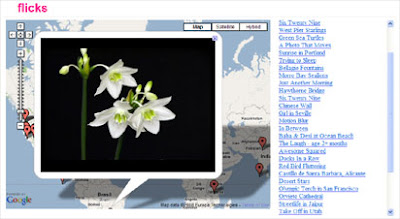
Flicks is the first Google Map site to take advantage of Flickr's hosted videos. The site is a selection of Flickr videos tagged on a Google Map. Flickr users can geotag their videos when they are uploaded to their account and Flicks uses these geotags to embed the videos on a Google Map in the exact position that they were shot.

Having a browse through the videos on Flicks, it soon becomes obvious that Flickr have succeeded in producing something different from YouTube. The video player is far more attractive and so far the quality of the videos submitted by users are of a much higher quality.

Trippermap


Trippermap is a web site that allows you to put a Google Map of your Flickr photos on your own web site or blog. If you haven't got a web site or blog it doesn't matter because Trippermap will host your map for you.

Trippermap supports photos that have been geotagged and will even map your photos if they are tagged with a city or country name. The Google Map has an easy to use interface. The photos are clearly tagged on the map and small thumbnails are placed in a strip along the bottom of the map to ease navigation of your photo set.

Other Flickr Maps

flickrvision
loc.alize.us
fotoland

__________

Saturday, April 12, 2008

Google Maps Mania turns 3 years old!

Hello to all Google Maps Mania faithful! Can you believe this blog turns 3 years old today? Way back on April 13th, 2005 I decided to start blogging about the chatter I was seeing around the web and blogosphere about Google Maps. Days later Google Maps code was hacked up by Paul Rademacher to give way to the first ever Google Maps mashup - HousingMaps. Not long after this x-Googler Bret Taylor and his team sanctioned the concept by making the Google Maps API available. The rest is mashup history and Google Maps Mania has been right there with you all along the way. There has been no shortage of content to blog about. In fact, I usually have several email contributions and a reserve text file teeming with mashups, tools and Google Maps links that I can't evenfind the time to blog about! The introduction of Keir Clarke has helped with this and I hope you continue to enjoy his posts. In addition to the 3 years of Google Maps Mania blogging I'm also very close to a milestone post so stay tuned for that in the next few weeks! Thanks for 3 great years!

Google Maps of Google Data Centres

Royal Pingdom


Royal Pingdom has made good use of Google's Maps to illustrate the location of Google Data Centres around the world. Being the world's favourite search engine takes enormous amounts of computing power and therefore Google’s data infrastructure needs to be huge and spread across the world. According to Google’s earnings reports they spent $2.4 billion on their data centres in 2007 alone.

Google is rather coy about how many data centres it uses and where they are located but Royal Pingdom have created some Google Maps based on information published by Data Center Knowledge.

As well as using static maps Royal Pingdom have also put together an interactive Google Map of the data centres at Wayfaring.


Via: TechCrunch

Thursday, April 10, 2008

Olympic Torch Relay on Google Maps

Google released their Olympic Torch Relay Map last week. I didn't post on it then because I thought it wasn't much use as an actual map. For example, if you zoom in on any of the cities involved there is no actual route of the relay through the city. Therefore if you want to know where to go to watch the torch relay the map isn't much help.

In London this was also a problem with the official maps released by the Olympics organisation. Here is the official map:


The route through London actually passed about a mile from my house. But because of the lack of detail in the map it was impossible to know which roads the torch was going to travel. I therefore missed the relay. My guess is that this was done on purpose to keep the protests down to a minimum. This might be why the Google Map doesn't have detailed routes of the relay - because the Olympics organisation are keeping it as secret as possible.

However I am posting on the Chinese version of the Google Olympic Torch Relay Map today because they have included video reports of the relay in their version of the Google Map.


The video content comes from CCTV which is a state run broadcaster in China. Unsurprisingly the videos don't seem to show the protests against the Chinese. However as a map I think Google China have made a big improvement on the work of their American counterparts.

Coincidently the 2012 Olympics are also occurring about a mile from my house. I am now worried that they will try and hide the 2012 games from me as well.

__________

Google Map of Augusta National Golf Course

The 72nd Golf Masters is under way in Augusta, Georgia.


The Masters Augusta Course is a Google Map of the Masters course at Augusta. The map gives a description of each of the eighteen holes on the course. The map also makes use of the Google Ajax Feed API to bring news of the Masters via Google, Yahoo and the official site of the Masters.

Other Golf Maps

Google Adds Google Streetview

Google has added Street View to the Google 3d Warehouse. The 3D Warehouse is a gallery of 3D models that you can download for Google Earth. Previously you could check the location of a building on a Google Map but now you can also see the building in street view (where available).


The map and the street view of the model are available via tabs at the top of the image of the model.

Via: Google Earth Blog

__________

Wednesday, April 9, 2008

Google Street View Comes to Trulia

The Real Estate search site Trulia has today added street views to its listings of houses. Now buyers on Trulia can use Google Maps street view to preview houses and the surrounding areas. For example, users can have a quick stroll around a neighbourhood via street view and scout out the cafes, parks, shops and schools. It should prove an invaluable aid for house hunters to decide which properties to visit.


Via: Google LatLong: Navigating the online real estate search

Read Google Maps Mania's first review of Trulia from October 2005

__________

Location Based Messaging on Google Maps

JotYou

JotYou is an interesting new concept in location based text messaging, which allows you to send an SMS to someone if they are in a certain location at a certain time. For example, if you are in a friend's neighbourhood you could text message them that you are in their favourite cafe and would like to meet. With JotYou your friend will only get the message if they are in the location at that time.

Alternatively, imagine you are in a bar. You could send an SMS to all your friends telling them where you are. Only those of your friends in that location or arriving in that location in a set time period would get the message. You can set and check the given location on Google Maps.

JotYou also uses Google Maps to set up tracking groups. With JotYou it is possible to track a group of friends as they move around town from your mobile phone or computer. Each of your friends locations are shown on a Google Map allowing you to easily see who is in your general neighbourhood.

This video explains it all far better:


Tuesday, April 8, 2008

Google App Engine With Google Maps

Last night Google launched the Google App Engine, which allows developers to run their web applications on Google's infrastructure. The new service allows developers to make use of Google's database BigTable and data store service GFS and will make it easier for developers to scale from one user to one million by taking advantage of Google’s scalable infrastructure.

Perhaps unsurprisingly just hours after its release two Google Maps Mashups have already emerged that have been built on the Google App Engine.

BarBound


BarBound is a social network for San Francisco that allows users to create a plan for a night out based on what their friends are doing. Instead of calling or texting everyone to find out where they are, users can find out ahead of time and plan before leaving home.

BarBound aggregates all the user contributed itineraries and shows the hottest places to go for any particular day along with the all time bars and areas of the city. Therefore before you start planning your night out you can check that evening's hot places on a Google Map. It is also possible to check on the map the hottest bars of all time.

On the simplest level you can use BarBound just to read reviews of bars and find out where they are.

Carpool

Carpool is a nice Google Mapplet that lets you search for a carpool for your daily commute. The application couldn't be easier to use. Users enter start and finish locations of their journey and the times that they wish to travel and the application displays the available carpools for that journey on Google Maps.

__________

Monday, April 7, 2008

The Google Maps Sea Level Rise Explorer


Robert A. Rohde has dropped us a line to share his new variant on sea level rise mapping. The Sea Level Rise Explorer describes itself as a Google Maps mashup that lets you explore the areas of the earth most vulnerable to sea level rise.

The site lays out and explains in detail the potential for sea level rise as well as the accuracy of the maps that are used. The Google Map that is featured on this wiki-style page includes a color coded map that shows the elevation of the land relative to sea level. This tool mashes up sea level data which is primarily from version 2 of NASA's Shuttle Radar Topography Mission (SRTM) and other sources.

You can even embed this tool into your own website or blog by following the directions on the
Embedding Sea Level Images page. The, map view on The Sea Level Rise Explorer along with the accompanying sea level rise predictions let you draw your own conclusions about how well off some parts of the world are from others in the years to come.

Other Sea Level Maps

Global Sea Level Rise Map - view the world at different rates of sea rise.
Sea Level Visualisation Mapplet - a seal level map for your iGoogle page
Flood Maps - also looks at the effects of sea rises on the world.
EarthTools - if you are worried about rising sea levels then try the elevation finder on this map. Click anywhere in the world and find its height above (or below) sea level.

________________

Skydiving on Google Maps

Super Skydive is a fun Dutch website that allows you to skydive above any location in the Netherlands.

Before you embark on your plane journey you first have to enter your destination (if you don't know any Dutch addresses try this one). When the plane reaches the skies above your destination a green light flashes and a film begins to play of someone preparing to skydive. The door of the plane then opens and you spring from the plane.


As you descend you can see your feet dangling over the satellite imagery of your chosen destination and the ground hurtling towards you.

This is a really great use of Google Maps' satellite imagery. Hopefully some other destinations will be added soon. I really want to skydive on the Giza Pyramids, the Eiffel Tower and Niagara Falls. So more soon please.

More Google Maps games

__________

Friday, April 4, 2008

Planning Your Vacation with Google Maps

If you are starting to think about your summer vacation then Google Maps is one of the best tools to help you pick, book and plan your trip. Here is a list of sites that that could prove invaluable:

Choosing Your Destination


TripTouch is a travel home page for independent travellers. What sets TripTouch apart is the sheer wealth of information available. Not only does the site provide information about various locations around the world, including weather reports and currency rates it also has a number of community features. Users can publish their vacation photos, blog about their trip and keep in contact with the people they meet.

TripTouch uses a small Google Map on each location page to illustrate the destination. The map can also be viewed in full screen.


Booking Your Accommodation


Map Channels Hotel Directory is an amazing Google Map that performs a hotel availability search of your chosen destination and then tags the search results on a Google Map. The results can be sorted by price, guest ratings or hotel name so it is very easy to quickly find the hotels within your price range.

When you click on a tagged hotel on the map an information window opens providing a picture of the hotel, the hotel's best rate and a link to more information.

If you are lucky enough to be heading off to France then CyberGites can help book your accommodation. The site is a directory of holiday rentals, bed and breakfasts, and camp farms in France.

You can search the directory by type of lodging and location. The individual results include details of each accommodation, a calendar of availability and a Google Map of where it is located.


Planning What to Do


Before leaving on your vacation it is always a good idea to find out a little about your destination and what you can do once you are there.

Nomao is a community recommendation service for places and events. It lets you search a location for restaurants, museums, activites etc. The results are then shown on a Google Map. When you click on a tagged result a user review of the location appears under the map.


Trusted Places is a similar website for UK locations. Each city page gives a wealth of information about this week's top community reviewed restaurants, bars, cafes and clubs. Clicking on an individual result will generate all the user reviews of that location, a Google Map and a list of other reviewed destinations near-by.


Other Travel and Tourism Related Google Maps

Thursday, April 3, 2008

Street View on Rocket Fuel

Street View Driver is a driving game that uses the new street view feature of Google Maps. The map is still under development but already it allows the user to navigate around a Google Map using street view as the interface. It is quite hypnotic to just press accelerate and let Street View Driver take you where it will.

Video Panoramas gives a taste of what street view would be like if Google used video instead of still images. The video panorama appears in a pop window above the Google Map and like street view you can pan around inside the panorama. However unlike Google's street view these panoramas are moving videos.


At the moment there are only two video panoramas but the site is promising to add panoramas of more cities very soon.

Mapped Big Wheel Race is a demonstration of how to map a YouTube video of a journey. Using the new YouTube API a video is synchronised with Google Maps so that when the location in the video changes a marker on the map also moves.


_______________

Wednesday, April 2, 2008

The London Profiler Google Map

Since we featured the The London Profiler back in January the map has gone to garner a lot of publicity. It has even been reviewed by the BBC.

Now University College London have got back in touch to say that they have added even more data to this impressive map.

One of the new data layers displays the relative concentration of ethnic groups in London. The last government census in the UK surveyed only 16 ethnic categories. 20% of Londoners however are from ethnic groups outside those categories.


The London Profiler uses people's names to go beyond those sixteen categories. The London Profiler uses the names listed on the electoral register to determine the ethnic make-up of London in much greater detail than the census.

Showing this data on a Google Map throws up some interesting results. For example, people with names of Polish origin seem to concentrate in a ring around central London corresponding to Zone 3 on the London Underground.

Combining information on ethnicity with data on deprivation also in the profiler throws up interesting avenues for further research and evaluation.

The London Profiler also contains a little Easter egg. Type in 'room106' in the kml search box and some portraits of the Geography Department at UCL appears on the map.

_______________

Tuesday, April 1, 2008

April Madness on Google Maps

Why is it that at the beginning of April every year we seem to get the weirdest Google Maps related stories?

Google Sightseeing today report about two new layers for Google Maps - X-ray and infrared thermal imagery. Google Sightseeing report that the new X-ray layer will let Google Maps users see inside buildings! I'm already wearing my lead underpants.

Sitening reports that the Google street view cars have been forced to paint road lines in Nashville. Whilst the German GoogleWatchBlog report that Google are replacing faces in the German version of street view with smiley faces.

Singeo report that the Singapore government is to ban Google Maps from mapping Singapore. They claim that the Google Map of Singapore is a direct copy of the geographic features of Singapore and a direct violation of their copyright on the country.

Google Australia have launched G'day mate which lets you search tomorrow's web today. I'm waiting for the first mashup with Google Maps. How about a map that shows where all tomorrow's traffic delays will be?

Google and Virgin have teamed up to create Virgle. Virgle plans to build the first human settlement on Mars. Now that Google Mars has been added to the Google Maps API we should see a whole host of mash-ups mapping this new settlement.


Popular Posts