Blog Archive

Showing posts with label driving directions. Show all posts

Tuesday, June 19, 2012

A Trip Planner with Weather Forecasts


If you are planning on taking a long road-trip this summer then the Weather Channel's new Hit the Road Google Map is the perfect application to help you plan your trip. Hit the Road not only tells you how to get from A to B but also tells you what what the weather will be like at A, at B, and at all points in between.

If the application shows that there is likely to be rain along your route you can simply drag the route line around the rain and see if the weather is predicted to be better elsewhere. Alternatively you can try adjusting the dates and see if the weather will be better if you start your trip a little later or earlier.

It is also possible to click on the route at any point to add a stop to your journey. If you add a planned stop then suggestions for places to eat and visit (from Yelp) appear below the map. You can select any of the Yelp recommendations to add them to your journey itinerary.

Monday, June 11, 2012

Driving Direction with Suggested Stops


Roadtrippers is a new Google Maps based trip planner. The application allows users to get driving directions between two locations in the U.S. and find points of interest along the route.

Using Roadtrippers it is possible to search for places of interest and good places to eat, drink and shop along a planned drive. You can search for points of interest in a large range of categories, including 'attractions', 'accommodation', 'shopping', 'food and drink' etc.

If you like the look of one of the recommended points of interest you can easily add it to your trip and the application automatically adds the stop to the finished driving directions.

Wednesday, June 6, 2012

Electric Car Distances on Google Maps


Jurassic Test is a Google Maps application that allows you to test whether different makes of electric car are able to complete a planned journey without having to recharge the battery.

To use the app you can choose from a large number of electric car models. You can choose a make of car to test by selecting the 'add a vehicle' button at the top right of the application. When you have selected your car(s) you just need to enter a start and end point for your journey on the Google Map (you can just click on the map twice to set two locations).

After you select the 'update' button beneath the map the battery icon next to the car(s) you have selected will estimate how much battery power would be used on your chosen journey.

Monday, June 4, 2012

Displaying Road Quality on Google Maps


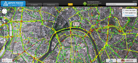
Rusdorogi is a Google Map that shows at a glance the quality of Russian roads.

Good quality roads are displayed on the map in green. Satisfactory sections of road are marked in yellow, unsatisfactory roads are marked in red, and the really bad sections are displayed in dark red.

The data for the map is crowd-sourced and is collected by the users of a clever Android application. The app senses the vibrations on the user's phone. It uses a specially developed method of data processing which assesses the types of vibration on the phone and distinguishes between data coming from the car and other, normal background, vibrations.

Thursday, March 15, 2012

Pothole Free Driving Directions


Pothole Season is a Google Maps based pothole reporting system with the added bonus of providing driving directions that returns the route with the least potholes.

Pothole Season is available for the iPhone and also as a desktop application. The app is aimed at Canadian roads but already seems to be gaining users in other countries. So far nearly 4,000 potholes have been reported in Canada alone.

Pothole Season is far from being the first pothole reporting Google Map but the addition of pothole avoiding driving directions should help to give it traction.

Hat-tip: Street View Funny

Friday, March 2, 2012

Recycling Google Maps Directions - Chicago


Recycle City Chicago helps citizens of the windy city find the closet recycling drop-off center from their location.

The application was the winner of the Green Opportunities Award in the Apps for Metro Chicago competition and it easy to see why. If users enter their address into the Google Map they can get turn by turn driving directions to their nearest recycling center.

If you click on a recycling center's marker on the map you can view the opening hours and the materials that can be recycled at the center.

Thursday, February 23, 2012

Auto-Rickshaw Fares on Google Maps


In India auto-rickshaws are highly unregulated and drivers often charge customers not on a fixed fare system but based on what they think the customer is willing to pay.

MeterPodu is an application designed to try and crowd-source auto-rickshaw fare information in a number of Indian cities and tell passengers what the approximate auto-rickshaw fare should be for their journey.

Using MeterPodu commuters can add their journey details to a Google Map and view the average fare charged for that journey based on what other users have been charged. Passengers then at least have some ammunition in the inevitable haggling over the fare with the auto-rickshaw driver.

Tuesday, February 21, 2012

Avoid the Cones - Driving Directions


ZoneCone shows the location of traffic cones (and therefore annoying roadworks) in Montreal Canada. On its own that would be a useful application for drivers but ZoneCone includes driving directions as well - so drivers can now get directions that avoid all those time consuming delays caused by roadworks.

The driving directions work similarly to the normal Google Maps driving directions. However ZoneCone also gives you warnings about all the road obstructions that you are likely to encounter on the route. In addition each warning comes with the starting and end dates of the planned work being carried out.

The suggested route that appears on the map is also editable. Users can therefore drag the route around obstructions and avoid all those annoying road cones.

Monday, January 9, 2012

Driving Directions with Suggested Stops


The RoadTrip America Map Wizard helps users find attractions and points of interest along a planned road trip route.

Using the app simply involves entering a start and end address and defining the distance from the route that you are prepared to travel to visit the suggested attractions. The route of your journey is then displayed on the map and the points of interest are displayed with categorised map markers.

The map markers are categorised into dining, events, historic sites, lodging, museums, natural wonders, parks & recreation and shopping. Registered users can save their favourite searched routes.

Tuesday, January 3, 2012

Google Maps Directions for Guide Dogs


KNGF Geleidehonden (The Royal Dutch Guide Dog Foundation) trains puppies to be guide or seeing eye dogs. To help promote the charity and help raise some of the mobility issues faced by the visually impaired KNGF have created KNGF Maps.

The map is a pretty impressive iteration of Google Maps driving directions. The map includes the usual driving, public transit and walking directions but also includes some novel seeing eye dog directions.

If the user selects the seeing eye dog directions they are presented with a blanked out map. When the user asks for directions a seeing eye dog walks the route and lights up the way on the map.

The map serves as a useful metaphor for the invaluable help provided by seeing eye dogs to the visually impaired. The map also includes the usual text based steps of the walking directions and can therefore also be read by screen readers.

Wednesday, November 23, 2011

Take a Street View Drive with Google Maps


I think there must be a rule in the automotive industry that you can't have an advertising campaign for a car without featuring Google Maps Street View. It seems it is is Peugot's turn to create an impressive Street View application to promote the Peugot RCZ.

RCZ View is an application that allows you to create any route in Google Maps and then watch a Street View stop motion animation of your created route. It takes a little while for the application to grab the Street Views for a route but it is worth the wait.

If you want to save a little time you can just watch the preprogrammed routes.

Hat-tip: Street View Funny

Friday, November 18, 2011

The MINI Takes to Google Maps

MINI Link (i-Tunes store link) is a free iPhone application that helps MINI drivers to connect with other members of the MINI community and share their favourite drives and tips.

Using Google Maps users can share their favourite drives, sights and dives and find out out the nearby recommendations by other MINI motorists. The application can also be used to mark the location of heavy traffic, cheap gas, or speed traps.

The app can detect other MINI motorists in your area and automatically send them a digital 'wave' or it can send a 'wave' manually to other MINIs anywhere in the country.

_____________

Thursday, November 17, 2011

Driving Directions with Suggested Stops


OnTheWay is a free application for travelers to quickly create personalized road trips. The application allows users to grab driving directions for a trip and provides suggestions of interesting places to stop along the route.

The route and the suggested stops are displayed on a Google Map. Users can click on the suggested stops' map markers and if a stop fits the bill it can be added to the driving directions.

Once you have planned your journey and added all the required stops the driving directions can be printed out and the trip can be shared by e-mail, Twitter or Facebook.

Thursday, November 3, 2011

Paris Biking Directions with Google Maps


French website Geovelo has created a handy biking directions application for Paris, Tours and Nantes using OpenStreetMaps and Google Maps.

The bike directions finder allows the user to select either the safest route or the quickest. The safest route will use dedicated bike paths where available, even if it results in a longer journey. The quickest route will just return the shortest distance.

After the user enters their starting point and destination the suggested route is shown on the map. Step by step directions are provided in the sidebar, alongside an elevation chart of the route. The route is displayed on an OpenStreetMap but users can also preview the route using the Google Maps satellite layer.

_________________

Thursday, October 27, 2011

Car Pooling with the Help of Google Maps


LaRoueVerte (the Green Wheel) is a French car pooling service that uses Google Maps to help users easily find or offer a car pool ride.

To find the nearest drivers willing to share a car journey the user simply needs to enter their starting point and destination. The route is then displayed on Google Maps and markers show all the nearest car pooling offers for the journey.

The details of the car pool offers are also displayed in the map sidebar with a handy meter guide to how closely the owner's journey matches the searched request.

_________________

Tuesday, October 25, 2011

Brazilian Directions with Points of Interest


Brazilian website Guiamais has created a Google Maps route finder for Brazil. The map also lets you search for local businesses and points of interest.

The route finder currently works for driving and walking directions. If you want to break up you journey you can also add points of interest to the map, such as fast food, banks and restaurants etc.

_________________

Monday, October 24, 2011

UK Roadworks on Google Maps


Today in the UK over 1,000 new roadworks began, causing traffic delays for commuters throughout the country. Roadworks Online is using Google Maps to help road users avoid those delays.

The map brings together live information on roadworks from local authorities and utility companies to show what work is currently being undertaken, why and by which organisation. Different types of map markers indicate the extent of the disruption to traffic (lane closed, contra flow, road closed, traffic lights, boards etc.).

It is also possible to click on a map marker to get more information about a particular street work disruption, including (where available) the proposed length of the road works.

_________________

All of Austria on Google Maps


AustroZoom.at wants to be your one stop map for Austria. The application uses Google Maps to provide access to over 522,000 Austrian business locations, localised weather information, route planning and much more.

It is possible to find business locations (such as local restaurants) by using the categorised links beneath the map. The slide menu at the side of the map provides links to the many other functions provided by this Google Map.

These functions include: traffic conditions and webcams, route planning, locally posted messages on Twitter, photographs & videos and local points of interest.

One very nice touch is the way the map has shaded out the rest of the world so that the focus of the map is centred entirely on Austria.

_________________

Sunday, October 9, 2011

Brazilian Taxi Fares on Google Maps


Tarifadetaxi is a Google Maps based taxi fare calculator for the major towns and cities in Brazil.

To calculate a fare with the map users can enter their starting point and destination into the search fields or they can just click on both points on the map. The app will then return a calculation of the fare for 'band 1' and 'band 2' journeys.

Users can also view the suggested Google Maps driving directions for the journey.

_________________

Tuesday, October 4, 2011

Win a Nissan Versa with Google Maps


Here is another great marketing campaign that uses Google Maps to effectively grab the interest of users and at the same promote a product. Nissan's My Versa Road Trip lets users share their favorite road-trips and have a chance to win a Nissan Versa or daily iTune gift card prizes.

To enter the competition you need to share your favorite car trip, by plotting the journey on a Google Map and selecting your choice of soundtrack. You can then view your road-trip animated on Google Maps, with Street View tours of all the points you entered on the trip with the chosen sound-track blasting away through your speakers.

As well as adding your own great road-trips you can browse the road-trips created by others. The animated tours, created with the Google Maps for Flash API, with Street View highlights and accompanying highlights are very impressive.

_________________

Popular Posts