Blog Archive

Showing posts with label Google Maps for Mobile. Show all posts

Saturday, August 20, 2011

Dead Zones on Google Maps


There are a number of Google Maps based apps tracking where you can receive good cell phone coverage (see Sensorly, OpenSignalMaps, Root Metrics). The Dead Cell Zones Map however is taking a slightly different approach by plotting locations where there are problems in cell phone coverage.


Using the Dead Zones Map you can view which cell phone providers have poor coverage in your location. You can even help improve the effectiveness of the map by adding any dead zones that you know about to the map.


________________

Friday, August 12, 2011

A Mobile Friendly Directions App


Mobile Place Maps is a mobile friendly directions map creation tool.


The tool can be used to quickly get directions on your mobile phone. It can also be used by businesses and other venues to provide a link to a mobile friendly map showing the directions to their business from the nearest subway or train station.


The tool automatically detects your current location, so all you have to do is enter your destination. After you have entered a destination the tool will create driving, cycling or walking directions for your journey. The route of your journey is displayed on a Google Map and step-by-step directions are displayed beneath the map.


Once you have created a directions map with the tool you are also given a weblink. It is therefore possible to share your directions map with friends or create a link on a website to your directions map.


________________

Tuesday, July 19, 2011

Building Outlines in More Cities

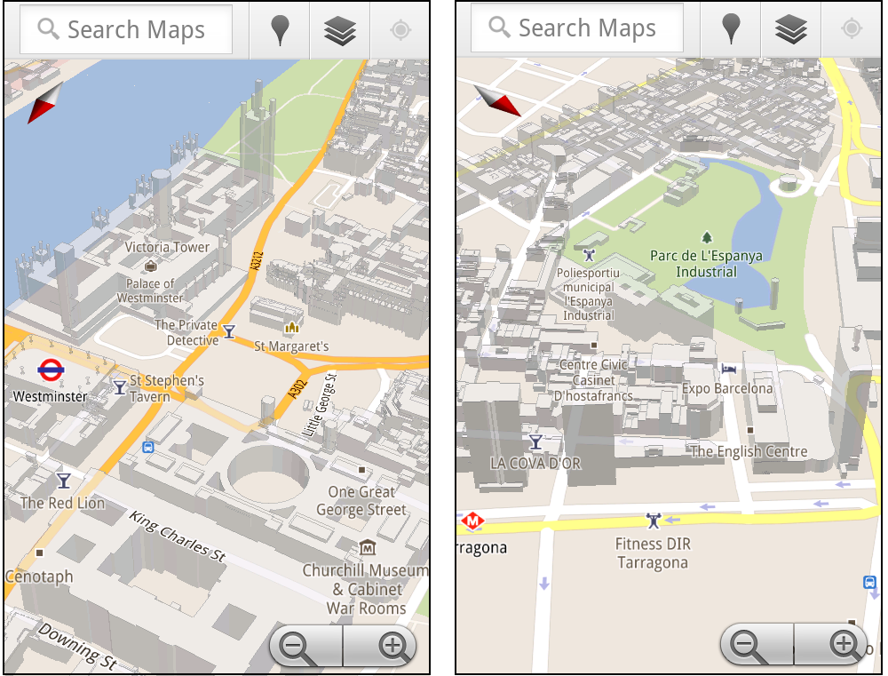
Google have today added 3D buildings to Google Maps in more cities around the world. The new cities include London, Paris, Barcelona, Stockholm, Singapore, Lisbon, Boulder, and 11 major cities in South Africa.

In Google Maps the 3D buildings look pretty cool but they really only come to life on Google Maps for mobile. On Google Maps for mobile you can rotate, tilt, and zoom in and out on the buildings.

My guess is that at some point soon Google will look to implement the rotate and tilt views in Google Maps for the desktop.

The rotating buildings obviously make more sense on mobile maps where the orientation of the map can rotate to reflect your view. However this would be a great feature to be able to access via the Google Maps API. I could see this being a popular tool with many map developers.

Via: Google LatLong

_________________

Wednesday, December 22, 2010

Finding Hiking Trails with Google Maps

TrailHeadFinder

TrailHeadFinder, the hiking trail directory, has released a mobile version of its Google Map of trails and campgrounds.

Using the application from your phone it is possible to find the nearest trails and camping grounds to your nearest location.

The difficulty of trails are indicated by the colour of the map marker on the map. Red markers indicate strenuous trails, yellow markers show intermediate trails and green markers show that the trail is fairly easy.

________________

Wednesday, June 23, 2010

Trains Added to Google Maps for Android

Google Maps for Android version 4.3 has added new features to help you quickly choose the right place to grab dinner, catch the next train, and find friends to add in Latitude.

Public transit station pages have been given a boost with Google Maps for Android 4.3. Now if you select a transit station icon on Google Maps you will find a handy list of the next departure times for trains, subway trains, and / or buses.


The new version of Google Maps also makes it easy for you to add friends to Google Latitude. At the bottom of your Google Latitude friends list you will now find a link to add more friends from your contacts list.

Google have also made it easier for Android users to get reviews of places. Instead of taking you straight to full reviews of places, with Google Maps for Android 4.3 you will now see color-coded review bars giving you an overview of what people think about the location. If you tap one of the review bars you can get more details like the actual review snippets.

Hat-tip: Mapperz Via: Official Google Mobile Blog

________________

Monday, June 21, 2010

Background Location Sharing on the iPhone

Loopt

Loopt has announced today that it will this week enable 'background location sharing' on its iPhone app thanks to new multi-tasking features in the Apple’s iOS 4. This means that users will be able to have Loopt running in the background and share their location with selected friends without having to specifically check in.

Loopt uses Google Maps to show you the real-time location of your friends. Loopt may also come with the option to share your location only at set times. The Loopt blog says "users choose which friends to include on the background location sharing updates, and how long to keep the location sharing turned on".

I take this to mean that Loopt will now have some form of time control. So you can select to share your location with different people only at select times of the day. For example, you could opt to share your location with your colleagues only during office hours.

The new 'background location sharing' means that Loopt can now push notifications to your iPhone when you have friends nearby, without you having to 'check-in'. It should also lead to a revolution in how location is shared in other iPhone applications.

Just wait for the thousands of companies releasing applications that will ping you when you are passing one of their stores. You may not want them but you can bet they are coming.

Via: ReadWriteWeb

________________

Sunday, June 20, 2010

Watch the World Cup Mobile Layer

Watch the World Cup
Google have created a World Cup layer for Google Maps for mobile that can help you find a bar or restaurant that is showing World Cup games.


You can view the "Watch the World Cup" layer by:
  1. Opening Google Maps on your phone.

  2. Opening the Maps menu and go to Layers > More Layers > "Watch the World Cup."
Once you have opened the layer you can find bars, pubs and other venues that are showing World Cup games near you.

________________

Sunday, June 13, 2010

The World Cup Location Based Service

FIFA World Cup Snag Wars

Forget about becoming the mayor of your local Starbucks and start grabbing territory for your favourite football team. FIFA World Cup Snag Wars, is a location based game for the iPhone. Using the Snag Wars app players can 'snag' and flag locations for their favourite World Cup teams.

Using the application players can snag their home, their local sports centre, football pitch or any other location. Each snagged location will then display the flag of their chosen football team.

Currently Australia are in the lead with 109 snagged territories, with Brazil in second place with 70 flags. The on-line website of Snag Wars also features a Google Map that animates through the locations of the latest snagged locations.

________________

Tuesday, June 1, 2010

Track Your Kids With Google Maps

ZenTracker

ZenTracker can track your child's location in real-time and send you messages if your child leaves a designated safe area. This child tracking application is built on top of the Google Maps and Google Latitude API's.

To keep track of your children your child's smartphone needs to be able to run Google Latitude. Google Latitude then keeps track of your child's location. ZenTracker regularly requests your child's geolocation from Google's servers. ZenTracker then checks the smartphone location against user-defined rules and sends you a notification if the location matches a specific rule, for example, your child has left a defined safe location.

Using ZenTracker users can define safe perimeters, such as the home or their school, so if a child leaves these areas a message will be sent to the parent.

Via: TechCrunch

________________

Wednesday, May 26, 2010

One Degree of Separation on Google Maps

Plyce

Plyce is the latest entrant into the location-based social network market. It is a market that is currently dominated by the likes of Foursquare, Brightkite and Gowalla.

Plyce uses Google Maps for many of its featured networking options. With Plyce you can find where your friends currently are and see which of your friends are around your current location directly from the in-built Google Map.

Plyce also lets you check for friends you have in common on Facebook with people around your location. So if someone in your immediate vicinity is friends with one of your friends they will show up on your map.

This one degree of separation feature could just be Plyce's unique selling point and certainly could prove to be a great networking tool.

Plyce also lets you check into and save your favourite places, gives you badges and has a weekly ranking table of users.

_____________

Monday, May 24, 2010

Google Open Sources My Tracks

My Tracks

Google have open sourced the code of their Android live tracking app My Tracks.

My Tracks enables you to record GPS tracks from your mobile phone and view live statistics – such as time, speed, distance, and elevation – while hiking, biking, running or participating in other outdoor activities. Once recorded, you can then view your track on Google Maps (Google have a number of samples of maps created with My Tracks here).

So if you are planning to build a real-time tracking application for the Android market then a good place to start could be the My Tracks source code.

Via: cnet

________________

Thursday, May 13, 2010

Your Google Maps Mission is ...

SCVNGR

Despite having never heard of vowels, SCAVNGR is actually a pretty cool new challenger to Foursquare and Gowalla.

One of the reasons that location-sharing mobile phone applications have become so popular in the last couple of years is that they have successfully turned location sharing into a game. It seems that a lot of people are actually very keen to become the mayor of their local Starbucks.

So one way to beat the successful incumbents in the location-sharing game may be to crank up the game element. Enter SCVNGR.

SCAVNGR, like other location-sharing applications, awards you points for checking into locations but you can also gain points for completing missions set by other users. The mission could be to take a photo, solve a riddle, scan a QR code or complete some other challenge. Succeed in your mission and you will earn extra points.

And we all know what points mean - prizes badges.

Currently SCVNGR is only available in the United States but there are plans to expand to other countries soon.


Via: ReadWriteWeb

________________

Wednesday, April 21, 2010

Google Maps Navigation Now in the UK

Engadget are reporting that Google Maps Navigation for Android phones is now available in the UK.


Google Maps Navigation has everything you would expect to find in a GPS navigation system, like 3D views, turn-by-turn voice guidance and automatic rerouting. Until now the service had only been available in America but Engadget reports that it is now also available in the UK.

________________

Monday, April 12, 2010

Celebrity Stalking with Google Maps

iPap

With the rise of smart phones the ability of individuals to share locations has risen dramatically. You would have thought therefore that celebrity tracking with Google Maps would have been a huge growth area over the last couple of years.

However Gawker Stalker seems to have given up on including a map on its site and Jaunted's Vancouver Celebrity Map and Toronto Celebrity Map don't seem to have been updated for a few years.

Celebrity stalkers will therefore be pleased to see the release of iPap. iPap is a celebrity spotting network for the mobile location sharing age.

Now if you spot a celebrity when you are out and about you can whip out your phone and go to ipap.me to report the celeb's location. The iPap home page features a Google Map where you can browse the latest celebrity sightings,

To make things more fun iPap also rewards celeb spotters with points. You get 100pts for every iPap you make and the site displays the weekly and all time time celebrity spotters.

________________

Another Location Sharing Service

Flook

Flook is a location browser for the iPhone. Flook allows you to discover interesting places around your current location by showing you 'flook cards' near by.

Flook cards have a full-screen photo and some text about the nearby points of interest and, over time, flook learns which cards people like most, and then shows them to you first. Flook describe themselves as "a bit like StumbleUpon for the world around you".

Flook users can create their own flook cards and share them with friends. You can also follow your friends on flook. So flook is also a bit like FourSquare and Gowalla.

As well as displaying user generated cards flook also creates cards based on other websites. Therefore you can use flook to discover upcoming events posted on Upcoming and other event sharing sites.

________________

Wednesday, March 24, 2010

Find Your Car With Google Maps

Where is My Car?

This mobile application has one simple but effective feature, it allows you to save a location in Google Maps. So for example, when you park your car you can find your way back to it's exact location. Or, imagine you have checked into a hotel in an unfamiliar city, you can store the hotel's location and always be able to find your way back no matter where you wander.

To store a location all you need to do is visit the site in your mobile browser. A draggable red marker will show your current location. You can drag the marker around to change the location and when you have pinpointed the location you wish to save just bookmark the map.

You now have a saved location. Any time you open the map now you will see two markers, one showing your current location and one showing your saved location. You can even click on your saved location map marker and get walking or driving directions to it from your current location.

Where is my Car? for mobile phones

_____________

Tuesday, March 23, 2010

Google Map of US Cell Phone Coverage

CNET Cell Phone Coverage Map

CNET have created a Google Maps mashup to compare cell phone coverage in the USA. The map shows the coverage of AT&T, Sprint, T-Mobile and Verizon in 16 US markets.

Currently the map shows data for the following locations: New York, Los Angeles, San Francisco Bay Area, Seattle, Chicago, Washington D.C., Dallas, Orange County, Las Vegas, Boston, Philadelphia, Atlanta, Minneapolis, Denver, St. Louis and Houston.

CNET teamed with Root Wireless to create the coverage map. The data was collected from client applications placed in consumer phones to record performance data such as data throughput, dropped calls, and signal strength.

The map uses coloured hexagons to show the signal strength in different areas. This allows the user to get a quick overview of where signal strength is good or patchy. It is also possible to click on any of the hexagons to get a more detailed breakdown of the signal strength at any location.

Hat-Tip: @geoparadigm

_____________

Wednesday, March 17, 2010

Google Maps Wallpaper for Mobile Phones

Google have released Google Maps for mobile 4.1, which has a lot of new features.

My favourite new feature is the Maps live wallpaper. If you press the “Menu” button from your home screen and select Wallpaper > Live wallpapers > Maps you can turn your home screen into a live updating Google Map (only available for Android 2.1+ phones).

Google have also updated the Google Maps for mobile search results page. The results are no longer shown with tabs but with buttons. The buttons allow you to view the searched place on a map, get directions, call it, or see it with Street View.

On Latitude phones you can also add the Latitude widget to a home screen panel.


Via: Google LatLong

_____________

Tuesday, February 23, 2010

Foursquare on Google Maps

CheckoutCheckins

CheckoutCheckins allows you to create a heat map of your Foursquare checkins. Once you log-in to the map with your Foursquare account it uses the places you've been to generate maps, charts, graphs, and stats.

CheckoutCheckins plots your last 50 entries using Google Maps and overlays a heat map of your most recent activity. The site also produces pie charts that provide a graphic presentation of your most often visited locations.

Via: Cnet

Where Do You Go?
CheckoutCheckins is very similar to the already established site Where Do You Go?, which also allows Foursquare users to create a heat map of their travels. Once you log into the site with a Google account and then authenticate with Foursquare you can create a heat map that visualises your location data using color on Google Maps.

Denser concentrations of color on the map indicate more Foursquare check-ins at a venue at that particular location.

Create Your Own Foursquare Google Map
If you want to add a Google Map of your Forsquare checkins to your own website or blog this tutorial is very useful.

In the tutorial Michael Pucher explains how to use your Foursquare feed with Google Spreadsheets to create a Google Map that will update with your latest Foursquare checkins.

______________

Tuesday, February 9, 2010

Buzz Locations with Google Maps


Google have today released Buzz, a new social network, status update, photo and video sharing tool (think Twitter, FriendFeed or Wave Lite).

Google Buzz for Mobile has a lot of exciting looking integration with Google Maps. Using Google Buzz on a mobile phone lets you tag your location. The tagged location will show up on your tag and your friends can click on it to see your location on Google Maps.

'Nearby View' will show all the public Buzz updates around your current location. The 'Buzz Layer' on Google Maps for mobile will help you find hotspots around your current location. These hotspots are presumably created by the number of 'buzzes' from a particular location. Therefore the hotspots could show you information about recent road closures, hot restaurants or bars or a local news event.

If you have a Gmail account you should see Google Buzz appear in the next few days.

_________________

Popular Posts