Wajam is social search extension for your browser that gives you access to the knowledge of your friends when you search with Google, Bing, Yahoo, Amazon, Yelp, Trip Advisor, YouTube and Ebay.
After you install the search extension on your computer you can log-in with Facebook, Twitter or Google+ to get access to all your friends' social recommendations.
One really neat function of Wajam is that it shows places your friends have recommended on a Google Map. For example, if you are searching for a restaurant you can quickly visualise all the venues that your friends have recommended.
Showing posts with label social. Show all posts
Showing posts with label social. Show all posts
Tuesday, June 26, 2012
Thursday, June 21, 2012
Geographic Micro-Blogging with Google Maps

SpoonerSpot is a new Google Maps based social network.
SpoonerSpot allows users to map the important places in their life or, as SpoonerSpot say, practice 'geographic micro-blogging'. Using the application users can virtually place short stories, called Spots, around the world and other users, who follow them, see those Spots on an interactive world map when they log in.
Adding a Spot to the map is very easy. Just right click on the map where you want to add a Spot, add your comment or story, add a picture (if you want), and you’re done. You can choose to follow any other users and you can browse the map by location, by people you follow or by Spots most recently added.
If you connect your SpoonerSpot account with a Facebook account your added Spots will also appear in your Facebook time-line.
Wednesday, May 9, 2012
Pin Your Media to a Map with Mapinterest

Mapinterest is an interesting social network built on Google Maps. The application allows you to pin media to places on Google Maps, follow other users, check-in at locations and explore places added to the map by other users.
You can connect to Mapinterest with a Twitter or Facebook account. Once you have connected you can begin adding places to the map. One of the most interesting features of Mapinterest is that it allows you to add media to place locations. Once on a place page you can add a link to a YouTube video, a Flickr or Instagram picture or even a Pininterest page and the video or photo is automatically added to the place page on Mapinterest.
Even if you aren't interested in joining a map based social network Mapinterest is a great way to share your videos and photographs with the world.
Saturday, May 5, 2012
The Street View Social Network

Wallit uses Google Maps Street View as the interface for a unique social network. Wallit allows users to create a virtual wall on Street View anywhere in the world, that they, and other users, can then post messages on.
Users of the Wallit iPhone app can find nearby virtual walls and leave a message on the wall. Users actually have to be physically near the location of a virtual wall in order to be able to add a message. This means to leave messages you need the Wallit iPhone application.
However, if you don't own an iPhone, you can still browse the virtual walls on the Wallit website using Google Maps Street View.
Hat-tip: Street View Funny
Monday, April 9, 2012
Add a Post-it Note to Google Maps

Pinwheel allows users to pin notes to a Google Map. The note can be about anything, from a reminder to pick up a cartoon of milk to advice about the best dish to try at a restaurant.
You can browse locations and view your own notes, the notes of people you follow or notes left by all Pinwheel users. If you see a note that you like, you can add it to your favorites by clicking on the heart icon.
Users can organise their notes into 'sets'. By using sets it is easy to create your own map of your favourite bars, cafes or anything else that you want to collect.
When you are out and about you can use the Pinwheel mobile page http://m.pinwheel.com/ to access your saved notes or find notes left by others around you (an iPhone app is also coming soon).
Thursday, March 15, 2012
Bookmark Locations App with Google Maps

Everplaces is a really nice new location bookmarking application. With Everplaces you can keep a record of all the amazing places you've been or those you'd love to try out one day.
Everplaces makes it very easy to add locations to your personal collection. You can painlessly import locations that you have saved in Google Maps. The Everplaces bookmarklet lets you easily add locations and venues that you find on other web pages. Everplaces also allows you to 'Explore' the locations added by other users and add those you like to your collections.
Whilst creating your locations collection you can easily share your favourite location finds with your friends via Twitter, Facebook and via the Everplace smartphone application.
Monday, February 6, 2012
Get an Uberlife with Google Maps
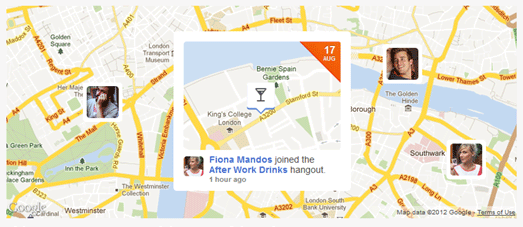
Uberlife is a website and iPhone app that helps you discover and join 'hangouts' taking place around you.
Using uberlife it is possible to find nearby events and hangouts happening right now or that are occurring soon. Users can add their likes and interests to their profile to ensure that they receive suggested hangouts from like-minded people. Users can also 'follow' other users to receive their 'hangout' suggestions.
To add a suggested hangout simply involves suggesting a venue (with the help of Google Maps), entering the time and date and adding some information about the hangout. If you find a hangout that you wish to attend you can view the location of the venue with the help of the Google Map added to the hangout page.
Monday, November 28, 2011
Google Maps of Your Encounters

Uencounter.me is an interesting application that allows you to build a social network around the important geographical locations in your life.
At the heart of the application is the My Encounter Map, a Google Map of the places you have lived and worked, the important people you have met at different locations and other locations that have been important in your life.
The social aspect of uencounter.me comes from comparing your Encounter Map with the Encounter Maps of your friends. Uencounter.me allows users to overlay another user's map on top of their own; allowing users to identify when they may have been in the same place at the same time. Furthermore, uencounter.me allows the user to identify how their links are connected – bringing the concept of 'six degrees of separation' to life.
Thursday, November 24, 2011
Location Sharing in Venezuela

Conoce is a location sharing website for Venezuela. The application is a great way to find and share travel experiences and places in Venezuelan towns and cities.
The submitted locations in each city are displayed on a Google Map. It is possible to search for nearby locations by category, for example 'restaurants', 'hotels', cinemas' etc. When you select a location from the map you can view user reviews and submitted photos and videos of the venue.
Monday, November 21, 2011
The Metro's Social Sharing Application

Check My Metro is a social sharing network for French subway users. The application allows travellers to share information about interesting and useful sightings made on the metro systems in Paris, Lille, Lyon and Toulouse.
The system is being used to report sightings of interesting buskers, graffiti, ticket checks, delays or anything else that might be interesting or useful to other travellers. Check My Metro is available as an iPhone, Android or desktop app.
The desktop version of Check My Metro comes with a useful Google Map that not only shows the Metro system for each city but shows the location of messages shared by the application's users.
Via: Geo in Web
Friday, November 4, 2011
Local Street Life on Google Maps

Streetlife is a UK based local social network.
The network allows users to find people who live nearby with common interests, get local news and find out about nearby events. Members of Streetlife also like to use the site to find and get recommendations about local businesses, offer time and skills and swap and exchange items.
The site uses Google Maps to show the local area and to show neighbourhoods nearby with active Streetlife networks.

nOtice.com is a UK based community notice board. It is a local social network where members can share local news, post details about forthcoming events or let people know they have something to sell or share.
nOtice.com uses Google Maps to show the area that members have subscribed to. The map includes a number of resize options, that allow the user to view a larger map or even a full-screen map of the area.
nOtice.com is currently in closed Beta testing but you can apply now for an invite.
_________________
Thursday, September 8, 2011
Meet New Friends on Google Maps
Meetbymaps wants to help you to grow your social network with the help of Google Maps. If you sign into meetbymaps with your Facebook account you can set your location and begin to browse other meetbymaps users nearby.
The map markers are coloured to differentiate users by gender (pink for female and blue for male). If you click on a marker you can discover basic information about the user such as their name and age. You can also choose to chat with other online users.
In the future meetbymaps plans to add photo sharing features and the ability to add points of interest and add locations where you can plan to meet other users.
________________
Friday, August 12, 2011
What's Happening on Google Maps?
Banjo is a mobile social networking application for the iPhone and Android phones that helps you connect with the people around any location.
When you open the Banjo app on your phone you can immediately see who is around you, no matter what social network you belong to. Banjo shows you Facebook, Twitter, Foursquare, Gowalla, TwitPic and Instagram updates from everyone who is nearby.
A really nice feature of Banjo is that you aren't restricted to just your current location. With Banjo you can view social networking updates from anywhere in the world. This means that if there is a big festival happening on the other side of the world, or a huge breaking news story occuring in another city you can open Banjo and view all the latest real-time social networking updates from that location.
________________
Thursday, May 26, 2011
Don't be Shy on Google Maps
Shy Breaker

Shy Breaker wants to help you overcome your normal reticence and meet other people through the Shy Breaker desktop and iPhone application.
Using Shy Breaker users can drop a note on a Google Map. The note can be about someone you've spotted and would like to meet or it could just be a note to say you would like to meet other like minded individuals. Users can time-stamp their notes so that they only appear on the map for a specified period of time.
If other people want to respond to your note they can reply to it and start a private conversation using the application's messaging system. I guess the rest is then up to you ...
_________________
Monday, March 21, 2011
Social Network - The Google Map
Xuland

Xuland is a Google Maps based social network that lets you share comments, pictures and links with those around you and search for venues, events and deals around your location.
Using Xuland you can comment on any location. If you like the comments of other Xuland users you can choose to 'follow' them. Xuland also has plans to offer comment badges soon to reward you for adding your thoughts.
You can also view nearby venues from Yelp, view deals for local venues from third party sites such as Groupon, and search for local events from Eventful.
________________
Sunday, January 30, 2011
Arrange to Meet with Google Maps
Seetio

Seetio is a new Google Maps based social network. 'Seetio' in Spanish is a homophone for 'sitio' which means 'place' and with this new social network you can save your favourite venues and arrange to meet at venues with your friends.
Seetio allows users to create collaborative events at any venue. Users can add Seetios or venues to Seetio by clicking on a Google Map and adding the appropriate information.
If you want to arrange to meet friends at a venue all you need to do is select a venue from the map and write a short message. You can then select which of your friends you want to invite or whether you want to send an open invitation.
You can log into Seetio with your Facebook account.
______________
Wednesday, May 26, 2010
One Degree of Separation on Google Maps
Plyce
Plyce is the latest entrant into the location-based social network market. It is a market that is currently dominated by the likes of Foursquare, Brightkite and Gowalla.

Plyce uses Google Maps for many of its featured networking options. With Plyce you can find where your friends currently are and see which of your friends are around your current location directly from the in-built Google Map.
Plyce also lets you check for friends you have in common on Facebook with people around your location. So if someone in your immediate vicinity is friends with one of your friends they will show up on your map.
This one degree of separation feature could just be Plyce's unique selling point and certainly could prove to be a great networking tool.
Plyce also lets you check into and save your favourite places, gives you badges and has a weekly ranking table of users.
_____________
Plyce is the latest entrant into the location-based social network market. It is a market that is currently dominated by the likes of Foursquare, Brightkite and Gowalla.
Plyce uses Google Maps for many of its featured networking options. With Plyce you can find where your friends currently are and see which of your friends are around your current location directly from the in-built Google Map.
Plyce also lets you check for friends you have in common on Facebook with people around your location. So if someone in your immediate vicinity is friends with one of your friends they will show up on your map.
This one degree of separation feature could just be Plyce's unique selling point and certainly could prove to be a great networking tool.
Plyce also lets you check into and save your favourite places, gives you badges and has a weekly ranking table of users.
_____________
Saturday, May 15, 2010
Google Maps and Location Sharing
Mappyfriends

Mappyfriends is a location based recommendations network that you can sign into with your Facebook or Twitter account. Using Mappyfriends you can show your friends where you have been and view their recommendations of places to go.
Once you have logged into Mappyfriends if you click on the 'News' link at the bottom of the Google Map you can view all your friends' latest recommendations. The recommended locations are then loaded in the map sidebar.
Clicking on any of the listed locations will zoom the map to a satellite view of the recommended place. You can then rate the location, click the 'I was here' button, or select one of the quick links to find a hotel, book a flight or discover more information about the location.
________________
Saturday, January 23, 2010
Local Knowledge on Google Maps
Askaro

Askaro has a pretty healthy pedigree. It is the new project from Eduardo Manchónwho, co-founder of Panoramio. Askaro is a hyperlocal site, that Manchónwho has set up with Ubaldo Huerta, to try and help people find out more about their neighbourhoods.
The site lets users exchange information where it matters the most, in our neighbourhoods and places of work etc. Users can ask a question in a specific area by placing the question on a Google Map, so that people who live or know the area can give an unbiased and helpful answer.
Askaro combines geolocation, and question and answer reputations, as the basis of its inner workings. Questions are asked, or placed, in a specific area of a city, in order to reach out to the people who live or know the area. Askaro give the analogy of placing a flyer at your local grocery store to reach out to locals.
Answers can be voted as "Good" or "Bad" by anyone, which has the effect of moving them up or down. The question's author can also designate a specific answer as the "Best answer". Best answers turn green and move to the top.
The number of votes and the answers marked as "best answer" are used to calculate the reputation score, which becomes a measure of how valuable each respondent's contributions and answers are. The users with the best reputation in a city can be found in the "Local Heroes" page.
________________
Wednesday, January 20, 2010
Community Mapping with Google Maps
HabitMap

HabitatMap was started in 2006 in Brooklyn to document the links between the built environment of New York City neighborhoods and the health and well being of the people who live, work, and play in these neighborhoods. Now the site is open to participants and contributions from around the globe.
HabitMap is a community mapping and social networking website. Getting involved is easy. Simply identify something in your neighborhood that either enhances your quality of life, such as a local farmers market or public park, or is cause for concern, such as a historic building threatened by bulldozers or a contaminated property down the block, and add it to a Google Map.
You can also create your own Google Map highlighting a specific area of interest, embed maps on your website or blog, invite fellow activists to contribute to your maps, and discuss issues and recruit collaborators in the HabitMap forums.
Here are some links to some of HabitMap's featured New York neighborhood Maps,
________________
Subscribe to:
Posts (Atom)
Popular Posts
-
Here again is another (the 11th) roundup of the latest Google Maps Creation (and Viewing) Tools and Resources. I've assemble these list...
-
+ = Google Maps Mashup Roundup Part 1 (of 2) ( See Part 2 here.. ) Google Maps is powering the Web 2.0 craze here in Canada . It is bringi...
-
Boston.com has used the previously mentioned Atlas Google Maps tool to create a map of the recent Mooninite scare in Boston . You might re...
-
Massachusetts contributions to gubernatorial candidates - Faneuil Media dropped by to tell me about a very interesting and eye-opening Goog...
-
Sacramento Crime Tracker - This next mashup is a great example of how media can use Google Maps to display information for those in the com...


