 Last week I posted about the newly added street and road maps for Torino (Turin), Italy. This convenient arrival meant that these road maps would help unlock yet another corner of the earth to users of Google Maps. This new mapping layer also meant there was new relevance to locations on the map, and foster new Google Maps mashups. After posting last week I received a few mashup submissions and a number of you posted comments about the Google Maps mashing that is being done in a build-up to the Olympics. Here are some highlights:
 Daily Event/Schedule and Result Map - Asktheworld.org provides a maps mashup that includes an events calendar, time of start, and then (live) results and medals. Click here to see the mashup. The map will show you the events of the current day, but you can also browse in the next days.
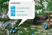 Olympic Venue Map mashup - Remo Madella has created this fine Google Maps mashup showing the locations of all the venues around Torino, Italy. Each map venue features a nifty wintry map pin with venue symbols and links to the official Olympic website that gives more information about the sport itself (Displays better in Internet Explorer than Firefox)
 CommunityWalk.com Olympic Google Map - DIY Google Maps site CommunityWalk.com sets the stage for this Olympic Map that displays Ceremonies / Activities Areas, Venues and Transportation. Others are welcome to help contribute to the map by clicking login to add to this community.
Olimpiadi di Torino - A Google Map (in Italian) showing locations around Torino with links to webcams, wiki entries, Flickr photostreams and external webpage links.
Google Earth Viewing - From the Official Google Blog: Virtually Torino - This post from Bill Kilday from the Google Earth Team will show you how to use Google Earth to explore the venues and scenery (in 3D!). The Google Earth Blog also contains more information.
Tagzania provides a collection of Olympic Venues - From Tagzania's Creator: Just some locations on Tagzania, with a combination of tags, lets you see the geographic picture: winter + olympics + 2006. If you add a tag, you restrict the map to locations on Torino itself (winter + olympics + 2006 + city) or venues for skiing competitions (winter + olympics + 2006 + skiing), or whatever. It's easy, 'cause the streetmaps displayed by Google thru the API already show the Olympic locations mapped. Look at this place for instance: those blue points in the streets of Torino are Olympic sites. Tagzania's views are set by default in satellite mode, but change to maps in all the examples above to appreciate the detail.
Technorati Tags: [Winter Olympics], [Torino], [Turin], [Italy], [Olympics], [Google Maps Mania], [Google Local], [Google Maps]


0 comments:
Post a Comment