Blog Archive

Sunday, April 30, 2006

Google Maps Mania update from Spain

Luistxo from Tagzania reports on the latest Google Maps buzz and cool stuff from Spain:

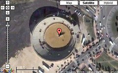
Helicoptero de Rajoy horas antes del choqueMain map-related news in Spain is the astonishing finding of a helicopter in a bullring in Móstoles, in the outskirts of Madrid. It just happens that the main opposition leader of Spain, Mariano Rajoy of the Popular Party, suffered an helicopter accident on Móstoles on Dec. 1, 2005. The chopper crashed just after departing from that bull-ring and, miracolously, occupants suffered only minor injuries (see Youtube video and read CNN story). So, when someone spotted this chopper there, the question surfaced: could it be that very same helicopter? And, according to this thorough investigation, the answer is YES: the image was actually taken minutes or a few hours earlier than the crash, on Dec. 1, 2005. Finally, that image got to Google Maps last weekend. Unbelievable.

Other items in Spain:


Guadawireless is a wifi user community in the city of Guadalajara (Spain), that has mashuped its wifi nodes, with realtime information of nodes active at any moment.

Like other cities, Madrid also got its metro lines mapped over Google Maps.

Two new map-maniac blogs in Spanish: TopoNorte, and Noticias Google Maps, which uses the very obvious URL Googlemaps.es. Ummm, maybe they'll get a call from a lawyer...

Google Maps now it's own Spanish address and functions, also viewable by mobile phone. The entering of Google in the local search area of continental Europe, has been accompanied in Spain by an alliance with the main yellow page provider in Spain, TPI (a subsidiary of Telefónica, big Spanish telco). The listings of Páginas Amarillas, the main product of TPI, are also listed as results in searches in Google Maps España, as while searching for Pizzas in Sevilla.

Spanish newspaper El Mundo is the first big media in Spain to make a mashup of its own, profiting from the new situation in Spain (as elsewhere in much of Europe), now that we have streetplans and roadmaps. It's Callejero or address finder is just that, for the moment. It works well, and it would be the same as Google Maps España itself, but it has a guided search, province by province, which is handy.


Interested in becoming a country correspondent for Google Maps Mania? We're looking for people to report on all the latest Google Maps mashups in Europe! Drop us a line if you're interested!

Saturday, April 29, 2006

100 Mile Diet Google Maps Tool

Many consider eating local foods one of the best ways to be environmentally friendly. The people at 100MileDiet (.org) made the 100 mile diet famous throughout the eco-blogosphere. They have a built nice little Google Maps tool that lets you find out what your 100 mile boundary is for eating local. Just pop in your zip code (US) or postal code (Canada) to get your boundary mapped. It's a sensible concept, and this Google Maps tool will help you to change the world while you eat. Learn more here...

Friday, April 28, 2006

Google Maps API now in more languages

Google product manager Jessica Lee has posted to the Official Google Maps API Blog to let you know that they have added translations to the Maps API to include more languages! Here is a short excerpt from her post:

We've also added translations to the API so you can get the map controls, tooltips, and copyrights in your own language. We currently have translations for Japanese (ja), French (fr), German (de), Italian (it), Spanish (es), Catalan (ca), Basque (eu) and Galician (gl). We'll announce more new languages in the coming weeks. [READ MORE..]

Google mapping the 2006 NFL draft

+
Google Maps mashup MapGameDay.com will be live Google mapping the NFL draft this Saturday April 29th. The drafted players will be shown by NFL team, hometown, and college team. In addition to the draft information, they will be using the Ginsu to allow fans to chop up the data (players closest to your zip code, drafted players by position by hometown, players most likely to build up lots of frequent flier miles from work to home, etc)... Check it out, it should be a lot of fun.

Related: NFL.com - Draft Page

Google Maps mashup nominated for a Webby!

A Google Map that Google Maps Mania played a part in creating is up for a Webby Award! DaveLovesElizabeth.com was created by Dave Garr when proposing to his girlfriend Elizabeth last October. The site brought together a rap music video, audio slide show, and of course - a Google Map of significant locations for the two of them. The site attracted quite a buzz on the blogosphere when it was posted. Now it's nominated for a Webby in the Personal Web Site category. If you feel that it's deserving, please vote here! -- If you're wondering, she said yes. ;)

Thursday, April 27, 2006

FIFA World Cup 2006: Google News Map Mashup

++
= FIFA World Cup 2006 Team & Venue News Mashup


Virender Ajmani is busy mashing up maps and news feeds once again. This time he has taken the Yahoo! FIFA 2006 World Cup RSS Feeds, Google News RSS Feeds and the Google Maps API to create a unique "News Map" for the coming World Cup event being held in Germany this June. The resulting map helps you easily read team news from each competing nation, as well as find news for each of the host cities.

Other Google Maps mashups for the World Cup:
World Cup Venue Map + Schedules
World Cup Venues Map - (in German)

Official FIFA World Cup Site

[Do you Digg it?]
Technorati Tags: , , , , ,

More about Google Maps in Europe

Earlier this week I reported that Google released street maps for.. *ahem*, Europe. I was sternly corrected by many of you in places like Latvia and other Baltic countries that the street data was not for "ALL" of Europe as I had stated in my post. Thanks to everyone that helped to let others know how the data looked in your corner of the world in the comments section of that post.

Google has since released separate Google Maps sites for some of the countries included in the update. Now when visiting http://maps.google(.de,.es,.fr,.it) you reach localised versions of Google Maps for Germany, Spain, France and Italy:


Thanks to Ogle Earth for this tip. Also in this Ogle Earth posting there is also some helpful information about the status of one-way streets and directions for the new street data.

:
In other news, here is the posting from the Official Google Blog about the release of street maps in Europe. Here is a quote from Google Maps product manager : "This has been a global effort with Google teams in Paris, Hamburg, Milan, Madrid, New York, Mountain View, Kirkland, Sydney, London, Dublin, and Zurich working together for much of the past year to build a truly "local" product." He goes on to state that for developers, Version 2 of the Google Maps API will need to be used to make this new street data present in your Google Maps mashups.

Wednesday, April 26, 2006

Live World Cricket Google Map

Here is new Google sport map for the cricket fans out there. The Cricketing Yak is a live up to the minute map which displays matches that are going on and the current score. Since some matches can last multiple days, the icons show these matches progressing. This map is employing many other Google technologies to bring you your cricket fix as well. A Google Calendar shows an extensive international match schedule (with links to Google Maps) and this scores map can be added as a Google Homepage Module. The map page indicates that a desktop sidebar plugin is in the works as well.

Technorati Tags: , , , , ,

Real-person, Real-time Google Maps mashups

ShakinDave.com is a website and real-person, real-time map mashup that gives you a potential glimpse into the future. Using a camera mounted on his glasses Dave Rheingold broadcasts live from the streets of New York and shows you in live time what he's seeing. He pipes his personal video AND audio to his website so you can tune into the action. Here is a list of all the gear he uses:

* Tablet PC (Motion Computing)
* EVDO card
* Video glasses
* Microphone
* USB analog-to-digital video capture board
* GPS receiver
* Backpack

For software, he uses a Windows XP Tablet, Windows Media Encoder, VZAccess Manager, and a custom-written application that transmits the GPS data and displays it using the Google Maps API. All of this results in a live video and Google Map that shows Dave's real time location. The result is pretty engaging. Sure, it is just Dave walking around, but between the video, sound and the way you can follow Dave with the Google Map, I have to say it's all pretty cool. Dave doesn't broadcast in a 24/7 format so he offers an alert service so you can be notified by email when he starts his personal broadcast. He is expected to be broadcasting today (April 26th) between 1 and 2 pm Eastern time (GMT -5).

Google Maps Mania IDEA: A major sponsor like Coke, or Verizon should try to get in on this and sponsor this real person website phenomenon. It's reality TV on demand, and mapped. Think EdTV.

Of note is a similar application like this called "Where's Tim." Where's Tim tracks the movements of Tim Hibbard through his mobile phone. While it's minus video and sound, it does have a PILE of bells and whistles: mileage for the day, RSS feeds and Google Earth viewing to name a few.

If you think this is cool, please Digg it! :)

Tuesday, April 25, 2006

New Google Maps mashups for Europe

Vienna, Austria - Here is a map for the Vienna Underground transit system. With the addition of street maps, this is a very functional mashup for the city of Vienna, Austria. More information on the map is in this blog post.

Germany - Here is a zip code viewer for those of you in Germany. The tool is completely in German and lets you type in German zip codes (plz) and the borders are then displayed on the Google Map. This tool has quickly been retrofitted with street maps as well.

Brussels, Belgium - Find a cafe or bar and browse locations of wall paintings in this mashup for Brussels. This mashup includes the street maps viewing option.

Paris, France - Here is a map of kosher restaurants in Paris. Restaurants are highlighted as pins on the map and upon clicking you can see all the metro stations that are close by. This mashup does need a quick retrofit to offer the user the option to toggle street maps on.


Other Maps
UK Bed & Breakfast Map
Gothic Architecture in France (click "G" in the Maps column)

Monday, April 24, 2006

Big News: Google Maps street maps for ALL of Europe!

Some loyal Google Maps Mania readers have tipped me off on some big news in the world of Google Maps - Street maps for all of Europe! What a surprise people will have when they wake up on Tuesday morning! Not only are street level maps now available (in addition to the satellite maps available previously) but so are driving directions! Google Maps Mania is about to erupt with more new mashups to come from this area of the world! :)

Help spread the word of this new data and Digg this story!

Update: Check the comments section for more information about the updated street map data in various parts of Europe as observed by many readers.

[Thanks to Ted, Frank, Stefan and Hermann-Marcus for the tip!]

How Google Maps is used in News & Media - Part 1

Media outlets, professional, and citizen journalists have discovered Google Maps and how it can be used to spotlight or illustrate issues as well as making a news story interactive. They have also been used to further enhance services directly on news and media websites. Others have created news maps from web-based news services such as Google News. In a multi-part series of posts I'll be showing you how Google Maps is being used on various news and media websites around the web. I'll close off this series by offering my own personal suggestions and observations for how this mapping technology could be further used in all types of media. Please feel free to contribute to this series by offering your comments and suggestions to these posts.

New maps (3):

WashingtonPost.com: Mapping US war casualties - Adrian Holovaty of ChicagoCrime.org fame took a job over at WashingtonPost.com as "Editor, Editorial Innovations" and he brought the Google Maps API with him. He has tipped me off on his first Google Maps creation since joining on: Faces of the Fallen is "a database of U.S. service members who died in Iraq and Afghanistan." You can browse the map by soldiers' hometowns or by state. There is also an advanced search function that displays your search results on a Google Map.

Bowling Green Daily News: Mapping Yard Sales - This daily news pub is Google mapping the locations of yard sales in the community. The map gets updated "on Thursdays by 10:00 a.m. for the upcoming weekend". Here is an excellent article from Editor & Publisher about this map mashup.

New York Times (Travel): Mapping each travel column - The 36 Hours column in the New York Times "offers a weekend-long itinerary for a different North American city each week." They have mapped each of the columns from the past 3 years on this Google Map. Story photos appear, as well as a link to the archive of that story. [Via JustinSomnia.org]


Previously mentioned on Google Maps Mania (13):

The Daily News (Longview, Washington): Police Blotter/Crime Map - Plotting local crimes
Sacramento Bee: Crime & Liquor Stores - Mapping the issue of crimes committed close to stores selling alcohol.
Times Herald-Record (Hudson Valley, NY): Gas Price Watch - Mapping gas stations and current prices.
Times Herald-Record (Hudson Valley, NY): Mapping a car accident story - This story page includes an interactive map where you can view where the accident took place. Here is another example of a bear attack on a camper.
New York Times: Transit Strike Map - Mapping transit alternatives and stories from the strike. The map lives on to serve a greater purpose.
News & Observer (Raleigh, NC): Traffic Map - Mapping NCDOT's live traffic cameras.
Lawrence Journal-World (Kansas): Mapping venues - This story page maps the venues that are referred to.
Freelance Writer: Flood Maps - This map was created by a writer who was preparing a story about the global sea level rising. He couldn't find a map, so he created one himself! Read his blog post about it for more.
The Star-Ledger (New Jersey) : Killers going unpunished - This map plots locations of murders and convictions
Toronto Star: 2006 Homicide Map - Mapping the growing homicide rate in Toronto
Toronto Star: Traffic Map - Mapping the locations of traffic cameras in Toronto
Rochester Democrat & Chronicle: Mapping 2005 Homicides - Showing locations of 2005 homicides.

(More examples to come in Part 2..)

Technorati Tags: , , , , ,

Saturday, April 22, 2006

Hot or Not + Google Maps Mashup (Part 2)

+
= MapLuv's HotorNot Dating Map


Steve Chua has taken the HotorNot.com website API and combined it with Google Maps to make yet another mashup of the wildly popular picture ranking website called: The HotorNot Dating Map.

Here are some of the features of his new babe-trolling mashup:

- Worldwide coverage (including Canada, Asia, Europe etc..)
- Users in the popup windows are ordered to make flipping back to a cute photo easy!
- Clean, easy user interface showing person's essay and full size picture
- Last location and settings recall. No user registration required. This is especially useful when you refresh the page - you stay put instead of getting sent back to an original start point on the map.

Check out the previously mentioned HotorNot.com mashup by Frozenbear.

New Google Maps Satellite Views

A rooftop proposal - Google Maps satellite views catch an aerial proposal in New York City. [via]

Google Maps illusion - Here's a cool satellite view in Dallas that appears to have 2 buildings leaning into one another. Satellite maps look to have been stiched together oddly in this one.

GoogolMaps is a new 'collections' site - Here is a new site with more neat Google Maps satellite views like the ones listed above.

Be sure to stay current with all this great satellite imagery in your own Google Maps mashup by upgrading to version 2 of the Maps API. The Google Maps API Official Blog posted yesterday about a planned update of satellite imagery that matches the same update the Google Earth database enjoyed earlier this week. The Google Earth Blog has an extensive wrap-up of what world locations were upgraded. Thanks to Ted Timmons at Sightseeing with Google Maps for this tip about the update!

For more sites that focus on neat collections of Google Maps satellite views check out my section called, appropriately: Google Maps Collections

Enjoy, and HAPPY EARTH DAY!! :)

Friday, April 21, 2006

9 new US Google Maps Mashups

Dr Vino adds New York City Wine Bars Map - Dr. Vino has been busy mashing up locations of NYC Wine Bars on this new Google Map. The map joins his NYC and Chicago Wine Shop maps. Check out more info on his blog post about the map.

Planet Hazard maps company emissions - Planet Hazard (.com) is a mashup of 86,000 US companies that emit hazardous air pollutants. Among the many filters to search for these companies is a top 10 list, and regional state, county and city viewing. [Via ProgrammableWeb]


More new Maps:

New Google Maps found through ProgrammableWeb:

Thursday, April 20, 2006

Google changes name from Local back to Maps

Update (Apr.21 1pm): Here is an update from the Google Blog: "Back on the map"

An observant Digg user has pointed out that Google has changed the Google Local name back to Google Maps. Google switched from Maps to Local back on October 6th, 2005. While the URL still resolves to local.google.com the title tag, title bar and the service name above the search field now say Maps instead of Local. Here is a before look. Google Local for Mobile appears to have kept the same name.

This name change does make you wonder what might be next from Google. Perhaps this could now mean that street maps will no longer hinge on an underlying business directory being present before they offer this map content to new countries. I'm not sure about you, but we here at Google Maps Mania feel MUCH better about the change of heart and wonder if there are any more plans in the works that accompany the product re-naming decision. Stay tuned!

Google Map of Tokyo Metro

The Google Maps API has been used to create a great Google Map of the Metro system in Tokyo, Japan. The map is completely bilingual and serves to help English and Japanese speaking riders. "Tokyo-Metro" and "Toei" Lines are sectioned off with the ability for you to select the routes within each line. Each station is then highlighted as a map pin so you can learn what transfers you can take in each one. Japan is a country that has seen the arrival of Google street maps, so you can toggle between street views (Japanese street labels only) and satellite viewing. There is even a "landmarks" toggle that lets you see notable locations such as Tokyo Tower, The Imperial Palace or Narita International Airport as they relate to the metro system. My description is only covering one of viewing interfaces! There is a completely different view with different functions if you click "Type 2" from the top of the map! This is a great Google Maps resource for people living in Tokyo, as well as for tourists visiting this great city!

Looking for more Google Maps mashups for Japan? Check here..

Who you gonna call? Google Maps!

+

David Friedman just made his first Google Maps mashup, and it's a pretty good one! He has mapped a tour of Ghostbusters Filming Locations. (IMDB.com: Ghostbusters, Ghostbusters II)

This link will be added to the Movie Maps section here on Google Maps Mania. This category organizes Movie related Google Maps that folks have created. There aren't many maps in this list just yet, but I feel it's a theme that will gain popularity. Be sure to also check out the growing list of TV Maps as well! :)

Maps and Mashups Blog and News Roundup

Mashups for fun--and profit?
C|Net News.com - Apr.20/06
Online growth maps a future
The Australian - Apr.20/06
Comparing the Mapping Services (Recommended Read)
TechCrunch - Apr.17/06
Making Money From Online Maps
Forbes.com - Apr.17/06
Optimize your roof ads for Google Maps
Natural Search Blog - Apr.13/06
Travel Maps Growth As Local Search Heats Up
HitWise - Apr.13/06
Webby Award Nominations -- Google Maps gets FOUR!
Google Blogoscoped - Apr.12/06 (Webby Awards)
Mash-up Apps and Competitive Advantage
Crossing the Rubicon - Apr.10/06
Google Maps API2 + Your Local Search Marketing Checklist
ISEDB.com - Apr.10/06
The intangible aspects of mashups matter most
Enterprise 2.0 Blog (ZDNet) - Apr.8/06
Personal Maps Emerge as Visual Mix Tapes (Platial)
National Public Radio (Audio) - Apr.7/06
Google Base begins to roll out the verticals
Web 2.0 Explorer Blog (ZDNet) - Apr.6/06
Where in the World is Eva Longoria?
Martin Lieberman - Apr.6/06
Wall Street Journal: Online Mapping
Travsite.com - Apr.5/06
Comparing the Cartography of Google Maps and Ask.com Maps Comparing the Cartography of Google Maps and Ask.com Maps Part 2
Eicher GIS Blog - Mar./06

Wednesday, April 19, 2006

Updates to great Google Maps Mashups!

Here is a short roundup of those mashups that have been previously mentioned but continue to see improvements to make them better.

Local News by zip code gets restaurants and movie theaters - Virender Ajmani's wildly popular Google News mashup that lets you search local news by zipcode has added restaurant and movie theater locations to the map. Using Yahoo!'s new Local Search v3 API he lets you turn pull in Indian, Italian and Japanese restaurants, as well as the locations of all movie theaters. This in addition to local news and traffic that was previously added.

New York Bar, Restaurant & Subway mapper gets directions - New York On Tap (.com) is a website that has integrated the Google Maps API with their database of 1600 NYC bars. They have just integrated subway directions to the subway map with the help of Greg Brail's web service. Set your start and destination locations (address, landmark, bar, or restaurant), then get directions. It pops up a DHTML window(draggable) with directions and estimated travel time, and plots a polyline of your route, and indicators for any transfers. For an example try searching: 67 E. 2nd St. to the Empire State Building..

MenuPages + Google Maps mashup expands cities - Will Schenk has continued his crusade to map the Menupages.com database. He started by creating a map of New York City menus and now covers Chicago, Boston and San Francisco


Other updates:

BackCountryMaps - A new maps module allows anyone to create up to 10 private or public maps, and LOTS of new featured map content. Also better gis base data (ie roads, streams, etc), better landsat7 overlay, terraserver aerial with gis base data, live weather and nexrad and better UI.
More Washington D.C. Boundary Stones added - Check out Mark Zimmerman's expanded map of the 1791-92 DC Boundary Stones that now has better imagery.. and more stones!
Tagzania is digging API V2 - DIY Google Mapper Tagzania has noticed that when Google Local updates imagery, this update is now visible in API mashups. Things like the National Geographic aerial visions of Africa seem to be present (zoom right in on these ones). Head over to Tagzania to make your own Google mapped tagged with your interesting locations.

Based on user feedback Interesting Google Satellite Maps lets you browse by location *and* category along with a "show nearby" entries feature. Mega Google API masher FareCompare has expanded airfare search to other parts of the world and HomePriceRecords.com now includes Los Angeles, Chicago, New York, San Diego, Las Vegas, and Seattle data, as well as some new look and feel.

Have you updated your mashup? Post a comment to let others know! :)

Google Maps Mania turns 1 year old!

Google Maps Mania's first birthday came and went this past April 13th! A hearty thank you to everyone that has been following along since the beginning or hopped on somewhere along the way. I hope you've found my 750 posts interesting and informative and I also hope this blog has inspired the birth of a few Google Maps mashups! Here's to another fun year in the world of Google Maps!

Tuesday, April 18, 2006

4 new U.S. Google Maps mashups: SF, Upcoming.org, virtual ads, Food

San Francisco Openhouses - Looking for an open house to visit this weekend? SFOpenHouseMap (.com) can help. If finds open houses by time, area of San Francisco and price range.

Upcoming.org + Google Maps = JibMap - Here is a mashup that takes RSS feeds from the user driven events site Upcoming.org and combines it with Google Maps.

Buy Virtual Real Estate on Google Maps - Virtual Trespassing(.com) explains itself as a Google Maps based site that will let you: "Rant, Express yourself, Advertise, Link your site or Tie your MySpace account to a location". Your property appears as a mini billboard on the Google Map that is displayed. There is information for the new user here.

Food community gets Google mapped - The food community site Chompster has created a Google Maps mashup that allows users to keep track of their favorite restaurants and discover other users' favorites. Features of the mashup are described on the site's blog.

Google Maps "The Big One" in San Francisco

Today marks the 100th anniversary of the 1906 San Francisco earthquake and fire. To commemorate this event Brian Morearty has created a fun Google Map simulation of an earthquake in San Francisco called - "The Big One". The map page opens with a peaceful, serene representation of the city. Cable cars buzz along the Powell-Hyde and California St. lines and a windsurfer enjoys his day on San Francisco Bay.. Then the fun begins as the Google Map starts to shake! Fires break out and the cable cars stop. The map then resembles the scene after you've unleashed a disaster on your city in SimCity. Although meant to be taken in good fun Brian does draw attention to the predictions of another earthquake. There's a page that talks about how to use the map and some of Brian's adventures in building it using the Google Maps API.

Monday, April 17, 2006

Australia Google Maps Mashup Roundup!

The lack of Google street Maps for Australia haven't stopped many Aussies from taking hold of the Google Maps API and making some very useful mapping mashups and tools based on the satellite imagery which is available today. In some cases they are leap-frogging Google's release of street mapping data and instead app creators are inserting alternate sources of Australian street maps into their mashups:

Google Maps + Street Directory Australia + Geonames.org
- I'll let the description from this mashup do the talking: "...Sick of being left out to dry while US, Canada, Japan and UK got their Google Maps lovin', I've decided to take matters into my own hands and create a mashup of Google Maps' sweet API, with Street Directory Aust's great street maps and with the free Geonames Web Services API."

Australia Luxury Hotels & Resorts Mashup - Luxury- Down- Under has integrated the Google Maps API on their Australian luxury travel site. The site makes use of satellite imagery to let you scope out the locations of resorts and hotels throughout Australia. Check to see if your travel agent is giving you the straight talk by checking if the place really is "on the beach". :) The site provides tons of information about each place and lets you book online - a great way for people overseas to save some money!

Google Maps API + MapData Sciences + Street-Directory - The Google Maps API has been used to create a front-end interface to two Australian street mapping layers and the Google Maps satellite layer. The tool will help to provide context to the satellite data that Google provides today. Zoom in and toggle one of the 3 optional views.

Here is a list of all of the other known Australian Google Maps mashups & resources:
Do you know of more? Post a comment! :)

Popular Posts