Phonelocator is a realtime tracking application for GPS enabled Nokia phones. It allows you to view the location of your phone and a trail of where it has been on a Google Map. Phonelocator also has advanced features like "Intelligent Update" that reduces the amount of data sent by the application and "Battery Saver" that turns off the GPS when the phone is stationary or the GPS signal is too weak.
It is possible to view a Google Map showing all Phonelocator users and registered users on their own individual maps. Here is the link to the map of all users. Clicking on a registered user's name will take you through to their individual map.
GPS Visualiser

GPS Visualizer is a free, easy-to-use online utility that creates Google Maps and profiles from GPS data (tracks and waypoints, including GPX files), street addresses, or simple coordinates. It can be used to see where you've been, plan where you're going, or visualize geographic data (business locations, scientific observations, events, customers, real estate, geotagged photos, etc.).
GPS Visualiser give you the ability to easily group markers into collapsible/hideable "folders" in a marker list, as in this example. GPS Visualiser can also read markers dynamically from a Google Docs spreadsheet, as in this example.
A quick scan of the main example page will give you a good idea of the multitude of other types of Google Map mash-ups you can create with GPS Visualiser.
GPS TOUR

GPS TOUR is a German language website that allows users to upload and share GPS tracks. It currently has over 10,000 tracks for mountain biking, hiking, biking and climbing.
GPS Tour has now added the option to view tracks with the Google Earth Browser plug-in. This means it is possible to follow tracks with a real sense of the terrain. If that doesn't give you an idea of the difficulty of a particular track each route also comes with a handy elevation chart as well.
Gointu

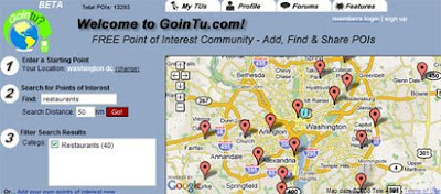
GoinTu allows you to download points of interest from a GPS device and view the download on a Google Map. Alternatively you can find points of interest via a Google Map and download the results to your GPS device.
GoinTu describes itself as a GPS points of interest community where members can create and share points of interest. It is possible to enter your own points of interest to the community, to rate and review POI and to recommend POI to other users.
The points of interest added to Gointu can be viewed on a Google Map. It is possible to search the database of POI via location and type and view the results on a map and / or download the results to a GPS device.
________________
0 comments:
Post a Comment