French website Vlib celebrated its one year anniversary recently. Vlib is a great map mash-up that shows bike rental locations in Paris. Renaud Euvrard has created a mobile application called Mlib' that means you can now find bike rental locations on your phone.
It is fairly easy to find a Vélib station in Paris, as they on many street corners, however the stations are often empty. Mlib allows you to find the nearest kiosk with bikes to your current location. Mlib is very quick to load and the content has been kept to a minimum to ensure ease of use.
French speakers can read more about the application on Renaud's blog Renalid.
MapMyWalk

MapMyFitness, LLC has a host of fitness mapping websites. Google Maps Mania has previously reviewed MapMyRide and MapMyRun.
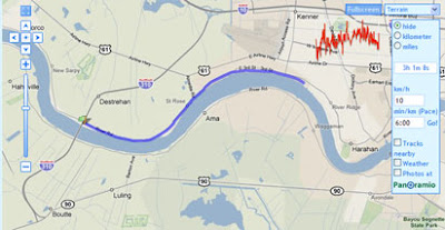
MapMyWalk allows you to plot your walks on a Google Map. Once you have mapped your walk you can view it in 3D with the Google Earth browser or on a Google Map and share it with your friends. Alternatively you can search for walking maps created by others.
The mapped walks feature a handy terrain view, so you can evaluate a walk's difficulty. It is also possible to embed a walk in your own website or blog by cutting and pasting a small piece of code.
TFL Cycling Maps

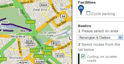
London's Transport for London website has added a Google Map of cycling routes in London to its website. To search the map you can choose what type of cycling route you wish to see, cycling paths, cycling on quiet roads or cycling on busier roads. You then have to choose which London borough you wish to find cycling routes for.
Here in lies a big problem. Because you can only view one borough at a time, when a cycling route moves into the next borough you have to guess which map you need to load to see the rest of the route.
There also seems to be a problem with the map's search option. I tested the map with a route I regularly cycle that is possible without cycling on any roads. For some reason TFL advised me to ignore most of the cycle paths on the route and to take a longer journey on a number of roads.
TFL provide free paper cycling maps for London. At the moment these are a far better option for cyclists.
Via: Mapperz
EveryTrail

EveryTrail is a GPS mapping community site that features hiking and cycling trails. Currently the site has over 130,000 tracked routes in over 130 countries world wide.
Recently EveryTrail has implemented the Google Maps Flash API to display geo-tagged photos alongside the tracked routes. This new feature means that viewing tracks is now a very pleasurable experience and the photographs give you a real sense of the views you can expect on a hike or ride.
EveryTrail allows you to download a KML of a track to view in Google Earth or download a track to a GPS devise. You can also embed a walk in your own website or blog by cutting and pasting the embed code.
GPSies

GPSies is a website that allows users to track cycling and hiking routes which have been recorded on a GPS device. It is also possible to download any of the routes to a GPS devise.
Each tracked route can be viewed on a Google Map. The routes come with an altitude profile so it is possible to quickly assess its difficulty. Each track also comes with a number of user ratings for landscape, condition etc.
More Walking and Biking Maps
- Walkscore - allows you to find walkable places to live.
- Ride the City - find the safest bike route between any two points in New York City.
- Tracks and Trails on Google Maps - a number of other GPS tracking sites
- CommunityWalk - plot and find walks
- CityBikeMap - track and find bike maps
- NYC Bike Maps - bike routes in New York.
- Utagawa VTT - This site lists more than 900 mountain biking routes.
- RouteYou - Community map site for walking biking, motoring and touring routes.
- Chicago Bike Map
- Phildelphia Bike Lanes and Trails
- Bikely - User submitted bike routes from around the world.
- Bikemap.net - 40,000 Bike routes mapped!
- I Need a Bike - A mashupof Velib.
0 comments:
Post a Comment