Lost-in-Bangkok

This on-line visitors guide to Bangkok features a searchable Google Map of things to do in the Thai capital. It is possible to search the map by region and by type. So, for example, it is possible to search Rachada for restaurants or Silom for bars.
The search results are tagged on the map and also listed in the sidebar. Each tagged location includes a brief description and is often accompanied by a photograph of the venue.
Vietnam
Focation

Focation provides travel information for Vietnam. Registered users can add their own tagged locations to the map.
It is also possible to just add photographs to the map and Focation has an additional Google Map mash-up of Vietnamese photographs submitted to Flickr and photos uploaded by its own users.
Malaysia
Mapdoo
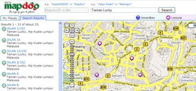
Mapdoo allows users to search for places in Malaysia. As Google doesn't provide geo-coding for Malaysia the developers have plugged in their own geo-coder to the search engine. It is therefore possible to search Mapdoo for streets, places and businesses in Malaysia.
Anyone can use Mapdoo for free and you can even add your own business to Mapdoo's listings. The map has thousands of businesses listed and it is possible to search this huge database of mapped locations either via a search box or by selecting type of business from a range of options.
My Hospital
My Hospital is a Google Map mash-up of government hospitals in Malaysia. The map comes with a search box so it is possible to search for individual hospitals or it is possible to search the map by state.
Singapore
Singapore VR
Singapore VR is a website featuring hundreds of interactive panoramic photographs of Singapore. The panoramas include Singapore's top tourist destinations and also many restaurants and other entertainment locations. Each panoramic photo is tagged on a Google Map. The video below provides a pretty good introduction of what you can find on Singapore VR.
Bali
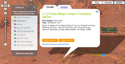
Bali Hotel Map

The Bali Hotel Map is a Google Map mash-up of resorts, villas and hotels in Bali. However the site has also geo-tagged hundreds of other places of interest to visit in Bali.
The site allows users to tag their own places of interest. Users can therefore add reviews and testimonials of their favourite restaurants and bars. And if you do find a hotel that you like you can even use Bali Hotel Map to book a room.
________________