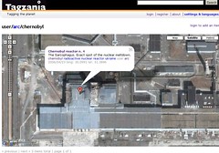
 Tagzania has some interesting maps of the Ukrainian city of Chernobyl which on April 26th marked the 20 year anniversary since a major radioactive fallout occurred there. Google Maps shows the exact location of the reactor n. 4, with the Sarcophagus over it. There is also a disturbing overview of Pripyat, the phantom city abandoned after the accident.
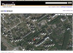
Tagzania editor Luistxo has this to say about the ghosttown you can now explore using the satellite imagery of Google Maps: "Void of people, the hood now surrounds the buildings. Strange, isn't it?"
 Over at the citizen journalist site LastingNews (.com) many nuclear themed maps have been created. The most interesting is a map which shows 19 significant global nuclear accidents that have occurred over the years. They have also plotted the location of the Siberian nuclear center of Angarsk (Russia) and the location of the Iranian Bushehr power plant construction site.
 Shifting from nuclear power to nuclear weapons, this last Google Nuclear Map is a tool which shows, using Google Maps, what the the idealized blast damage from any high-yield explosion. The tool allows you to choose various US cities or lat/long to center the blast. Set the number of KT's and see what area a high-yield detonation would spread over.


0 comments:
Post a Comment