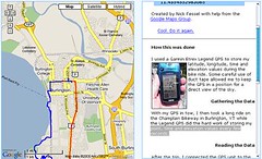
Nick Fessel took a bike ride on a Burlington, Vermont bike path. Equipped with a GPS unit duct taped to his bike, the unit recorded the point, time and elevation values every few seconds during his ride. When he returned home, he translated these values to usable data that the Google Maps API could use to show you his route on a Google map.
Here is the end result of his work and his open invitation to anyone interested in using his code to do something similar..
[
via]


0 comments:
Post a Comment