Blog Archive

Wednesday, September 28, 2005

Google Maps tidbits..

If you're a regular Google Maps Mania reader you may have noticed I've been a bit thin on posts over the past few days. I'm working out of town this week and not able to post as much. Here is a short roundup of items to keep you up to date on the Google Maps world:


The AllPoints blog points out that the City of Portland website now features Google Maps integration for advanced property searches.
Updated: Changed city from Seattle to Portland.

The conversation continues on the Google Maps API Google Group in the area of for-profit, commercial mashups. Simple answer. Read the Terms and Conditions and FAQ. Don't worry, it's not a long, tough legal read.

If you're a GuestMap user like me, you might want to take up the blogger at ennovy.org on their offer to use a nifty little chicklet for your blog or website. I'll be changing my text link with this soon.

Jason Salas is so envious of ChicagoCrime.org's Adrian Holovaty. He also has some thoughts on why the Google Maps API has been used in more recent mashups over the competing Microsoft Virtual Earth API.

Karen Ruby wonders when the other big papers in Canada (Globe and Mail, Canoe, National Post, etc.) will follow the lead of the Toronto Star in developing Google Maps mashups for their online news stories.

A Flickr user has posted a message about a Google Maps - WordPress plugin.

How-To: ArcIMS to Google Maps

GoMap integrates with Google Maps [via]

Tuesday, September 27, 2005

Google Map that flight!

fboweb.com has apparently integrated flight tracking with Google Maps. Here is more from their site:

"Last year, fboweb.com and Google worked some wizardry together and teamed up to enable easy flight tracking straight from the famous search engine.

We've now integrated their fantastic GoogleMaps application with our free flight tracking feature that functions off of their site.

You can go straight to Google and enter commercial flight information, such as "United Airlines 11" or even "UAL 11", and you'll be presented with an option to track the flight using fboweb.com and the new maps!"


Check it out here:

Some new Google Maps mashups and tools

Here is a great new mashup that for all of the New York City Traffic Cameras

A nice tool that allows you to find multiple points of lat/long for multiple coordinates. [via]

A few Google Maps overlays showing you the locations of petroleum refineries along the Louisiana and Texas coast. These overlays show you the location of natural gas terminals, transmission stations and pipelines. In the wake of hurricanes in these areas some have discussed the damage of these locations affecting gas prices.
Petroleum Refineries near Houston and Texas City, TX
Petroleum Refineries near Port Arthur and Lake Charles
Petroleum Refineries near New Orleans, LA

RealTravel.com travel journals and reviews recently integrated with Google Maps.

And finally, a while back I commented that the Libmap UK mashup should win the contest put on by IdealGovernment.com to find Google Maps mashups using government information in the public domain. Seems it was one of the winners! :)

Monday, September 26, 2005

Google Maps Hacks - O'Reilly

Update (Jan.25/06): This title is now shipping from Amazon - Order yours now!

+ = "Google Maps Hacks" Book

O'Reilly, the publisher of great computer books and the beacon for emerging tech trends has announced their forthcoming Google Maps book titled: "Google Maps Hacks". This shows O'Reilly's commitment to this emerging technology and also proves that Google Maps mashups are here to stay. Here is a description from the O'Reilly website:

"The nearest pizza, the cheapest gas, the best meeting place for a group-Google Maps Hacks shows you creative ways to add to and customize the satellite images and underlying API of Google Maps for applications serendipitous or serious. Written by Schuyler Erle and Rich Gibson (with a foreword by Google Maps tech leads, Jens and Lars Rasmussen), Google Maps Hacks shares dozens of tricks for combining the capabilities of Google's Keyhole map feature with your own datasets, so you can create interactive maps for unlimited personal and commercial applications." (read the full description..)


This will be an essential guide for anyone that is making use of the Google Maps API to create Google Maps mashups and integrations. Be sure to pre-order your copy so that you are among the first to be equipped with this valuable knowledge from O'Reilly.

Other related O'Reilly titles: Mapping Hacks, Web Mapping Illustrated, Google Hacks (2nd Edition

Google Maps from blogs and news..

Some recent Google Maps related blog posts and news stories..

Spot the black helicopter, win t-shirt
The Register (UK) Sept. 23/05
Our recent spate of Google Earth and Google Maps probes - highlighting how the firm's tasty satellite imagery is threatening all decent Christian, democratic values with its hi-res imagery of military hardware - has provoked a mini-airburst of reader activity. In fact, so great have been the number of recommendations for Israeli nuclear installations, Russian trailer-launched nukes and US stealth aircraft that we have decided to run a small competition to find the best that Google has to offer.

Honolulu-city.com - The 1st Honolulu internet Portal
PRLeap - Sept. 25/05
The Honolulu Business directory "Yellow Page" will allow advertisers to submit their business free and be reachable by visitors but the interesting thing about it is to see a clear map of location and direction using "Google Maps" technology.

Search FAST, Inc. Adds Google MAPS to Their Local Search Service
eMedia Wire - Sept. 24/05

CityCrybs.com Simplifying the Search For Homes With RSS Feeds, Google Maps
PRWeb - Sept. 26/05

Fun With Mashups blog post
Web 2.0 Explorer Blog: ZDNet - Sept. 22/05
Mash-ups are one of the most entertaining aspects of Web 2.0. It can take many forms and in this post I'll touch on some of them.

Press Release: Sportsim with Google Maps and Google Earth add on
LocationIntelligence.net - Sept. 21/05

Saturday, September 24, 2005

Spanish view: Town boundaries in Catalonia and more..

Luistxo is back from Tagzania to report on the latest Spanish Google Maps mashups from around the web..

Vista Satellite is another satellite sightseeing web from Spain. If you have visited this kind of
site, you'll already be familiar with of some the places featured here.

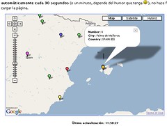
A Spanish professor at the University of the Balearic Islands, Ricardo Galli, has written a program that, installed in a site, features in a Google Map where people are accessing form. Galli mentions that his inspiration has been Mailinator, and has freely distributed his program (GPL) and has published instructions in Spanish. They have also produced some demo videos showing all accesses of a given site over 24 hours. Check the application running and view the videos at the end of the blog post. The image below showing the map centered in the island of Majorca, where Galli has created this thing.

Access detection mapped

Another interesting demo mash-up is the one created by Just Van denBroecke. He has worked over previous work to create new enhanced examples that add WMS layers to Google Maps, which permit mixing images from web-based GIS applications that deliver data in the WMS standard. One of the examples shows boundaries of municipalities and comarques (catalan shires or counties, we might say) plotted over Catalonia in Google Maps. The WMS layer is served, in this case, by the Cartographic Institute of Catalonia.

WMS + Googlemaps in Catalonia

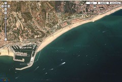
The result is truly interesting, but when zooming close we see that there is some mismatch in the coordinates. Click on the image to see the effect on the harbour of Arenys deMar. On the left side, you'll see also the municipality boundary with the town of Canet de Mar.

Meanwhile, the people at http://www.geocoder.com.ar are intensely developing their tool: they have translated the interface into English, now offer geocoding via HTTP requests, and they also do inverse geocoding: you click on a given point of a map showing Buenos Aires, and they return the street name on screen.

Google Maps as art

Jennifer Gruzca has a great idea for the use of Google Maps satellite views on blogs:

"..The colors, textures, and shapes of satellite views of the Earth can amazingly beautiful, and sometimes quite strange. Can you guess where any of these are from? (And yes, one of them is very easy!) Just click on the image to find it on Google Maps. Find your own pieces of satellite art and post them on your own blog, or leave a link to the location on Google maps in the comments!"

Slices of these images are below, go to her blog post to check it out further..


[via]

Vote for the best location on "TopSpot-Or Not"


Here's a new Google Maps "Collections" site to keep you busy this weekend! TopSpot-OrNot follows in the same naming footsteps as the ever popular Hot-OrNot mashup and gives you the chance to virtually travel to over 3000 locations around the world. The key feature to this site is that you vote for these locations as being your favourite places in the world. Check out the current list.

Enjoy!

Friday, September 23, 2005

Google Maps Mania updated with 80 new links!

We've updated the mashups and tools index on the right side of the blog with approximately 80 new links. What does this mean? It means that all the Google Maps mashups, tools and integrations that have been posted about recently are now included in the Mashups and Tools Index. If you are reading this posting via an RSS or a newsreader, now might be a good time to hop over to the web version of this blog to check these out!

This update continues to make Google Maps Mania the most comprehensive resource for Google Maps mashups and news!


Technorati Tags:

Google Map shows location of approaching Hurricane Rita

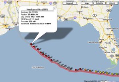
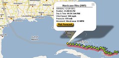
The FLHurricane.com Hurricane Rita Google Maps tracker continues to update the progress of the approaching hurricane on a Google Maps interface:


Related News/Photos:
Flickr: Hurricane Rita
Google News:
Hurricane Rita
Google Blog Search: Hurricane Rita
Technorati Tag: [Rita]

VisitPortugal.com uses Google Maps

+

The Portuguese Tourism Office has launched their integration with Google Maps into www.VisitPortugal.com recently. The integration, includes only hotel search results for major cities, with plans to expand it further. Here is an example:


Technorati Tags:

Why Mac developers should lie to Google Maps

In this Mac Dev Center article titled "Why You Should Lie to Google Maps" Matthew Russell shows Mac developers just how easy it is to integrate Google Maps in to Mac OS X applications.. as long as you lie a bit. :)

Here is a bit of the article:

..Fortunately for OS X developers, integrating Google Maps into your apps is cake. In fact, I almost decided not to even mention it -- but I couldn't resist because I thought the broader context of it all deserved some discussion.

Using WebKit, you can create a browser by writing only one line of code. Yes, ladies and gentlemen, it's true. Instead of reinventing the wheel here, however, take a look at the Mac DevCenter BYOB tutorial. When you build your own browser, you could go ahead and load up Google Maps right away, but it won't be a very friendly user experience. You'll be told that your browser isn't supported, and if you load the page anyway, you'll get slammed with intermittent messages like this one time and time again. Eventually, you'll risk losing your patience. Let's not go there.

"But Safari uses WebKit and it works fine on Google Maps.
(..read the entire article..)

Thursday, September 22, 2005

How-To: Movable Type blog posts + Google Maps

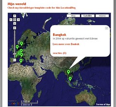
Dutch blogger Jaap van Oort has mashed up his blog posts with Google Maps to show you where he is posting from. His Movable Type blog posting template is based on scripting from the popular "Google Maps EZ". He used the code from this site and modified it using MT-tags. He has even created this great "How-To" Guide for you to do this yourself!

Here is an example of this in action showing
the location of Jaap's recent blog entries:


This is a great 'how-to' for mobile bloggers or backpackers that have the technical acumen to implement this on their Movable Type blogs!

3 new Google Maps mashups!

Jabber Google Map - From the "Jabber" Wikipedia entry: Jabber is an open, XML-based protocol for instant messaging and presence. Jabber-based software is deployed on thousands of servers across the Internet and is used by over ten million people worldwide, according to the Jabber Software Foundation. The Jabber Google Map shows the positions and status of Jabber users on a Google Map interface.

Colorado Bike Shop Map - Registered Users of Trail Central.com's membership list are laid out on this Google Map.

Free Wifi in San Francisco - A Google Map to find locations offering free wifi in San Francisco.

Google Maps Tools Roundup..

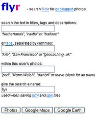
Flyr: A Flickr + Google Maps search tool - Here is a cool tool that allows you to search the Flickr image site for keywords in text, titles, tags and descriptions... pretty much anything that is searchable within the Flickr site! Dubbed "Flyr", your search results can be displayed as regular Flickr image results, plotted onto a Google Map or even opened up as an overlay in Google Earth.


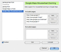
Google Maps Mousewheel Zooming - This Greasemonkey script, once installed, will add support for mousewheel zooming on Google Maps. To reiterate, this is not a Firefox extension, rather a script that rides on top of Greasemonkey. Once you have installed Greasemonkey on your Firefox browser, open the script, go to the 'Tools' menu and click 'Install User Script'.

photo credit - Earthhopper
[via]

Hotel listings mashup releases plugin - Reservemy.com was one of the early hotel search sites to integrate Google Maps with their search results. They have released a Firefox plugin that allows you to search Reservemy.com's hotel listings straight from your Firefox browser.
->


Google Maps tool helps you find U.S. zip codes
- This might be a re-post from a previous entry but you can always be reminded about this great Google Maps tool - click the U.S. map.. get the zip code. That easy.

Google Maps Tool Update: The previously mentioned "Areometer" tool has changed it's name to The Planimeter!

Toronto Star + Google Maps = Toronto "News-Maps"

+ = Toronto "News-Maps"

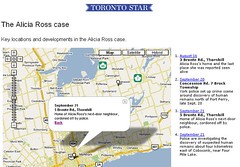
The Toronto Star has informed me about their second Google Maps application for a breaking news story. This time the subject of the news-map is the case of a missing woman named Alicia Ross. The news-map displays key locations and developments in this case.


The previous news-map that The Star released was a map displaying all of the homicides committed year to date (2005 only) in the Greater Toronto Area. The Toronto Star is continuing to be a Canadian online news innovator with these latest additions to their online content.

Wednesday, September 21, 2005

Google Maps Mania + Gridskipper.com = urban travel mashups

+ = urban travel mashups!

I've joined on with Gridskipper.com (a Gawker Media blog) as a regular contributor of "Google Maps mashups" that relate to world cities and urban environments. Gridskipper describes itself as the following: "...Scouring the world for discount flights, chic hotels —and pretty people. Gridskipper, the decadent travel guide."

Each week on Gridskipper you'll see a roundup of Google Maps mashups and tools from content here on Google Maps Mania. I'll keep you up to date on these "roundups" or you can subscribe to this RSS feed that will update your news reader when a new post from me goes live.

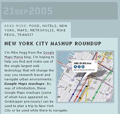
Here is my first post that hit Gridskipper.com today which is titled: "New York City Mashup Roundup". It covers helpful Google Maps mashups and tools for navigating 'The Big Apple' as a visitor to this city.. Enjoy! :)

Forbes.com: Mapping The Web's Future

Here is a good article written by Tom Taulli for Forbes.com which looks at the recreational and business applications that Google Maps (and the mashup craze) has presented..

Mapping The Web's Future

Forbes.com - September 21st, 2005

Benfield thinks online maps will increasingly become the interface for the Web. "In building its map application, Google made use of a new way of programming Web applications," said Benfield. "It is known as AJAX. Also, Google created an API, allowing users to implement maps within their own applications. Almost overnight, this has made MapQuest almost irrelevant."

Already, there has been an explosion of Google Map applications. As evidence, take a look at
Google Maps Mania. Many of these applications are grass-roots efforts, such as celebrity maps, which locates the homes of stars like Brad Bitt and Alyssa Milano, maps to find cheap gasoline and even a map of UFO sitings.

However, the mapping phenomenon is not just about fun and games. Companies like Salesforce.com (nyse: CRM - news - people ), a leading CRM software developer, are using Google Maps. Basically, you can map your business contacts and leads. So, if you plan a business trip to New York, you can see your contact base around the city and, thus, perhaps set up more meetings.


(read the entire article..)

CommunityWalk.com comes to life

CommunityWalk.com has really sprung to life with over 30 communities that have now been created. CommunityWalk gives you the ability to create your own Google Maps overlay. Uses range from local mountain biking locations to non-profit groups plotting locations of their members.

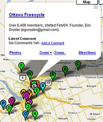
An example of this is how the Eastern Ontario Freecycling Group that has made extensive use of CommunityWalk's functionality by plotting the locations of their member groups. The info-balloons feature info about the group and link to the associated Yahoo! Group. Based on this being the top CommunityWalk "community" with over 8000 visits, it's clear that people are making use of this.


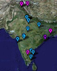
Meanwhile LiveJournal user Swamysk has used CommunityWalk to create a ">map of historic sites and places of interest in India.


It should be an interesting place to check out in a few months. I suspect many of the self created mashups that I'll be checking out and talking about here on Google Maps Mania will originate here.

Tuesday, September 20, 2005

Google Maps Hurricane Rita Tracker

Google Maps Hurricane Rita Tracker - As Hurricane Rita goes back out to sea after crossing over the Florida Keys you can track her progress in the coming days with this Google Maps integration which mashes up data from FLHurricane.com and Google Maps.


Related News/Photos:
Flickr: Hurricane Rita
Google News:
Hurricane Rita
Google Blog Search: Hurricane Rita
Technorati Tag: [Rita]

Jeep uses Google Maps API in online ad campaign

MediaPost Publications reports that the Jeep Chrysler Group has used the Google Maps API in an upcoming online ad campaign. WeAreTheMudds.com has been set up for the campaign which follows the accounts of a family of "Jeep enthusiasts". Here is more from the news story:

For now, the site--which features a family of Jeep-enthusiasts, the Mudds--is a bit of a tease. It includes brief bios for each of the Mudds--Brock, the father; Tracy, the mother; and their children, Clay, Summer, and Victoria. The site also includes a link to Victoria's blog--eventually, the other characters will also have blogs. The other familial blogs will be rolled out in the next two weeks, leading up to the Commander's Oct. 1 debut. In addition to the teaser site and the blogs, the campaign's centerpiece will be a series of four downloadable videos, which will feature Mudd family vacations. Each video will reveal coordinates to a virtual "geo-cache"-- geocaching is a hobby involving trekking to some remote location, burying a "cache" of items, and then posting the GPS coordinates of where that item can be found, so others can dig it up. Web site visitors can "dig up" the Mudd's caches by using an application designed with the Google Maps application programming interface. Each time a user digs up a cache, they are entered in a sweepstakes to win, among other things, a Jeep Commander--a seven-passenger trail-rated vehicle. (read the entire article..)

..There is no sign of the 4 videos which will feature the GPS coordinates for the mentioned "virtual geo-cache" just yet. It should be interesting to see what form this Google Maps integration takes!

Something to watch for!

[ Thanks for the tip from Directions Magazine's AllPoints Blog on this one! ]

Monday, September 19, 2005

Spanish View: Housing in Madrid and geocoding in Buenos Aires

Luistxo is our new correspondent covering all the great new Google Maps integrations and websites that are appearing in the Spanish language web world. Here is his latest installment..

Spanish View:
Housing in Madrid and geocoding in Buenos Aires

Just as Vivirama did last week with Loquo ads for Barcelona, another classified housing resource with maps in Spain. In this case it's for another Craigslist clone, Habitamos, which has ads for the whole of Spain, but maps now for Madrid, at Habitamos Maps. Unlike Vivirama, this is not a 3rd party development, they have done it by themselves, and they include thumbnail images. Habitamos is a start-up that launched in November 2004. From comments that they have made on the announcement of this tool, they have the same problem as Vivirama: difficult and expensive geocoding in Spain, that's why they offer just one city for the moment. But they
promise that additional cities will come.

Buenos Aires at Geocoder.com.ar

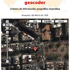
Expensive and difficult geocoding is also the rule in Argentina, but some have begun to overcome that. Geocoder.com.ar gives lat/lon locations, shown on Google Maps, for addresses in Buenos Aires (federal capital, not the province), and placenames all over Argentina. For instance, this Avenida de Mayo, 525, site of the provincial government. They plan to add more capabilities (English intefrace among them) but they would like more help. Postal-code geocoding has been achieved by the authorities, but the people at geocoder.com.ar have complained that the government sells it at 2,500 $ instead of offering the data.

Google Maps blogging tool: gFeedMap

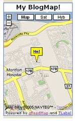
gFeedMap:


Here is an awesome Google Maps/FeedMap/TLabel mashup that displays the location of feeds on a dynamic map called gFeedMap. Kalu Kalu who attends the University of Waterloo in Waterloo, Canada has created a great tool that can be used by bloggers to search for other nearby bloggers and also place a Google Map FeedMap badge on their site instead of the Microsoft MapPoint that is currently utilized.

Features:

- Browse for blogs around the world
- Get a BlogMap for your website, like the one on this page
- Popup descriptions for each blog
- Visit any blog on the map with a single click
- Satellite view of the Blogosphere

Confluence Explorer - confluence points on Google Maps

Update Sept. 20/05 7:15AM: link corrected

Confluence points are the locations where latitude and longitude lines cross. Confluence Explorer shows full degree confluences for most land masses in the world plotted on a Google Map interface. This map joins other initiatives like the GeoProject USA.

TimTV: Google Maps person viewer

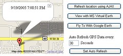
Tim Hibbard wants you to know where he is. So much so that he carries around a mobile phone equipped with a a java GPS application that captures the current position and sends it to a server. The server then exposes this information via a web service so that a GPS parser can parse it and display it via this nifty site called: "Where's Tim?". This site features a ton of different ways to view the location.


'Where's Tim?' has some pretty neat features - jump-off capability to Google Earth, Microsoft Virtual Earth views and even an auto-refresh so that you don't miss a second of Tim's movement around the community of Lawrence, Kansas.

Here is some further explanation from Tim about the application:
My company (EnGraph) has written some software components that take basic GPS data and do cool stuff with it. We have teamed up with another company (Air-Trak) that has written a program called Cloudberry that runs on Nextel phones. This Cloudberry application runs on the java platform on the Nextel phone, reads the GPS data and sends it to an online database.

Other possible applications: Pets? Children? Vehicles?

WalkJogRun.net releases new centering feature


WalkJogRun.net is a Google Maps mashup/tool that has taken the Pedometer concept to the next level. It allows you to use all the features and functionality of the Pedometer, but also gives you the ability to save your run routes and view popular routes for cities throughout the world. A friend of mine who visited Vancouver, Canada recently made use of WalkJogRun.net while there on vacation to reference what run routes were suggested for that city. Before leaving, he even created and saved his own for others!

To make using the tool easier, the site has just added a feature that attempts to locate your IP address and if it finds it, should will roughly center the map around your neighborhood. This is a feature that should be considered for any mashup which is intended to be used locally.. especially for a local fitness tool like this.

..If you dig the new "merch" WJR has added as much as I do, you might even consider picking up a nifty "tee" to show off to your running friends what a tech-savvy runner you are! ;)

New Google Maps sightseeing tool

Sightseeing with Google Satellite Maps is a popular site which categorizes and indexes interesting locations from the Google Maps' satellite view. They have recently added a cool feature that allows you to quickly check out nearby locations to the one you are presently viewing.

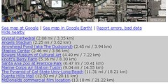
In the location view, look for the link called "Show Nearby"...


Here is an example of the new feature that shows you the aerial view of Disneyland in Anaheim, California. If you are planning a trip to this destination, the feature will show you all area nearby attractions:


This is a great tool to use when searching for other tourist activities to take part in at destinations around the world! :)

Google Maps Mania: News Roundup

INTERNET TOURIST: Zoom in, zoom out - Web maps allow you to scout your trip
Kansas City Star - September 18th, 2005
“Guidebooks can’t match the amount of coverage that Google Maps offers,” he said. “Also, guidebooks tend to point out the most popular and easy to access spots. But with Google Maps, you’re in control of choosing a spot based on access, terrain, structure and other criteria that you may not find in a guidebook.” - Google Maps Mania gets a mention in this article! :) (read entire article..)

Look what I clicked on ... Snoop on the world's top secret sites from your desktop
Guardian UK - September 16th, 2005
The South Korean government wants answers from its US counterpart about why South Korean military facilities are on plain view to any North Korean spies. A Thai military spokesman said: "We are looking for possible restrictions on these detailed pictures.. Quite a few American bases, too, are present in perfect detail. Khanabad, the US outpost in Uzbekistan, is shown stacked with large jets. (read entire article..)

Independent software development results in new map-based services

M-Travel.com - September 14th, 2005
New Web sites from Google Inc. and Microsoft are encouraging independent software development, leading to new map-based services, according to Informationweek.com. (read entire article..)

Enthusiast uses Google to reveal Roman ruins
Nature.com - September 14th, 2005
Using satellite images from Google Maps and Google Earth, an Italian computer programmer has stumbled upon the remains of an ancient villa. Luca Mori was studying maps of the region around his town of Sorbolo, near Parma, when he noticed a prominent, oval, shaded form more than 500 metres long. It was the meander of an ancient river, visible because former watercourses absorb different amounts of moisture from the air than their surroundings do. (read entire article..)

Maps On The Move
Internet Week - September 12th, 2005
The global market for mobile location-based services, including mapping, is expected to zoom from less than $1 billion at the end of 2005 to more than $8.5 billion by the end of 2010, according to research firm Juniper Research. (read entire article..)

Web Maps Offer Info, Aid to Katrina Victims
National Geographic News - September 12th, 2005
Most of the images currently on the site are about a year old. But when Hurricane Katrina hit, Bret Taylor, product manager for Google Maps, and his team began developing an updated version of the New Orleans region. (read entire article..)

Saturday, September 17, 2005

Google Maps imagery update

The imagery behind Google Maps and Google Earth has undergone an update:

Global Imagery Updates

Very High Resolution Areas
Jacksonville, FL 2004; Los Angeles, CA 2003; Oxnard, CA 2004;Tampa/St.Petersburg 2002

New High-Resolution Areas
Wilmington, NC; Myrtle Beach, SC; Quito, Ecuador; Caracas, Venezuela; La Paz, Bolivia; Canary Islands; Brussels, Belgium; Rotterdam, Netherlands; Belgrade, Serbia; Vilnius, Lithuania; Riga, Latvia; Kiev, Ukraine; Mumbai, India; Bangalore, India; Hyderabad, India; Kuala Lumpur, Malaysia; Hiroshima, Japan; Kobe, Japan; Osaka, Japan; Kyoto, Japan; Nagoya, Japan; Sapporo, Japan; Shanghai, China; Saertu, China; Havana, Cuba;

Updated or Additional Coverage Areas
Nashville, TN; Quebec, Canada; Buenos Aires, Argentina; Sao Paulo, Brazil; Venice, Italy; Milan, Italy; Birmingham, UK; Plymouth, UK; Dublin, Ireland; Frankfurt, Germany; Vienna, Austria; Warsaw, Poland; Istanbul, Turkey; New Delhi, India; Taipei, Taiwan; Seoul, South Korea; Pyongyang, North Korea; Stockholm, Sweden; Cape Town, South Africa;

[via]

Friday, September 16, 2005

Ontario Parks on Google Maps

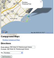
The Ontario, Canada Provincial Parks system has integrated the Google Maps service with their park listings tool. After locating a provincial park based on your requirements the results page features a map link that plots the specific park you've chosen. They have also integrated the Google Maps directions feature as well, but since some of the parks are in very remote locations this can of limited use.

Here is an example using the Provincial Park I grew up minutes from:


..This is the second Canadian-based mashup I've seen this week. Since I'm a bit short on Canadian listings, if any of you know of more that are Canadian-based Google Maps mashups or integrations, please post them in the comments section! :)

[thanks to the creator of TheStar GMap overlay for this one!]

Thursday, September 15, 2005

Toronto Star website displays 2005 homicides

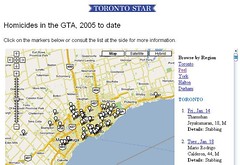
A hot issue in the city of Toronto, Canada these days is the rising number of homicides and use of guns in a city that typically does not see this current level of gun related deaths. It's a matter that has brought celebrities and city sports teams like the Toronto Maple Leafs and Raptors together to take a stand against the issue. The Toronto Star newspaper has created a Google Map to give some visual perspective to how many homicides this really is, and in what parts of the city these crimes are taking place. Each white pin represents another name of a homicide victim and the date it took place within 2005. Toronto is a great city and I hope this problem can come under control and no more pins are added to this map.


On a side note, this appears to be the first example of a major Canadian media outlet making use of the Google Maps API to display a current event or issue. Let's hope we'll see lots more from the creative team at the TheStar.com..

4 new Google Maps mashups!

Map of the Stars on Google Maps - Have you ever wanted to take one of those Hollywood California tours to see where the big stars live? Don't bother! Celebrity Maps is better! Those tours will only get you to the big gated entrances where the dogs bark at you. This Google Maps overlay will allow you to view the Google Maps satellite view of the property! Get those restraining orders ready..


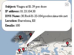
Spammers plotted on Google Maps - Mailinator.com is a free web-mail service that has decided to show you on a Google Map where spammers that are currently hitting their servers are geographically located. From the site: This map shows (in semi-realtime) ip addresses that are currently sending the most spam to Mailinator. Note: Spam counts are rounded to the nearest hundred and the map is updated every three minutes.


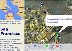
Boating in San Francisco - Here is a site for all those boaters in the San Francisco Bay Area. After choosing a region from the static map you get detailed Google Maps for each region. It plots locations of marinas, boatyards, yacht clubs, or other marine locations.


Chicago Drink Specials - The name says it all.. Open up the map and find your bargains.. Bottoms up! :)

eBay Motors Google Maps mashup


The Business 2.0 Magazine blog B2Day has reported on a Google Maps mashup created byAdam Trachtenberg that takes eBay Motors auto listings and plots them to their respective locations on a Google Map. Erick Schonfeld makes a good prediction with this mashup:

"...But let's suppose that eBay Motors does eventually incorporate the mashup into its site. What happens when Google starts inserting local text ads into its maps, or requiring that people who use its maps data do so, like Microsoft wants to do? Then what you would have is not just a map mashup but a business mashup. eBay would incorporate Google's mapping technology on eBay Motors to sell more cars, while Google would sell local search ads that appear on eBay's site. It will never happen. But if it did, it would be so Web 2.0." (read his post)

Check out the eBay Motors Google Maps mashup..

[via]

Wednesday, September 14, 2005

Google Maps Tool: Areometer

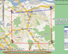
Inspired by the Gmaps Pedometer, Jef Poskanzer has made created the Areometer Google Maps tool that computes the area enclosed by a given path. His tool uses completely accurate spherical geometry, including drawing great circle arcs instead of straight lines. There are a couple other features of interest to Google Maps authors: it remembers the most recent position/zoom/map-type in a cookie; and it correctly handles lines & regions that cross the International Dateline. Try it out..


..Some of Jef's previously featured mashups here on GMM were: Transpac Yacht Race , BART transit map , Paris Metro Map .. Some great work!


Technorati Tag:

Google Mapping Britain's Hidden History


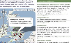
YourHistoryHere is an interesting new Google Maps project aimed at providing unusual information about a place a building or a street in locations around Britain. If you know "Some odd factoid, rumour or tidbit? Share it here, and if you're lucky someone will follow up with more info on your place."

Here is an example of one of those pieces of odd history about Scoles Manor:
The medieval hall house/chapel which is a part of this building has holes in the east wall. There are two theories. One is that they were for monks to leave food for lepers. The other is that they were people to keep bees in.


This is a great idea, but only if people take part. My advice - get your father or grandfather in front of this! They (or you) could be there for hours :)

Some additional notes from the creator:

1 - The code for this (excepting Google maps) is open source, and
we'll be happy to give it to anyone who wants an off the shelf
annotation system for whatever purpose.

2 - Both sites syndicate their data freely, and in a
location-queryable fashion. This is really important, as it allows for
all types of nice local history to be syndicated to tourism sites,
local community discussion boards, blogs and so on.

Google Maps lookup for Wikipedia articles


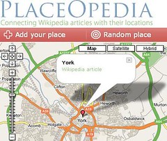
Placeopedia is a Google Maps mashup that connects Wikipedia articles with the places they represent. The idea is to create a browsable database that links to actual Wikipedia articles. From the creator: "We hope that lots of people will connect places they know with their corresponding Wikipedia article, and then our syndicated data can be used as a general geographic lookup table for Wikipedia".

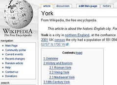
Want an example? Matthew Somerville has added a pushpin to this Wikipedia article
about the town of York, in England:

==>

When you click on the pin you link off to the article. The concept puts geographic association to wikipedia articles! Know of some good Wikipedia articles for this? Get placing and linking to help get this database started!

Some additional notes from the creator:

1 - The code for this (excepting Google maps) is open source, and
we'll be happy to give it to anyone who wants an off the shelf
annotation system for whatever purpose.

2 - Both sites syndicate their data freely, and in a
location-queryable fashion. This is really important, as it allows for
all types of nice local history to be syndicated to tourism sites,
local community discussion boards, blogs and so on.

Popular Posts