 IN..
IN.. 
Google Maps Mania - The Japan View
nagoyan the earthhopper is our eyes and ears for what is happening in the Japanese Google Maps world. He's back to help Google Maps Mania readers understand all the great things happening in this language on the web. (I'm looking for Google Maps Mania correspondents in other local languages - French, Portuguese and Mandarin/Cantonese.. If you're interested, drop me a line!)
This is nagoyan the earthhopper from Okinawa, Japan.
I am just writing this while the strong typhoon Nabi is hitting us right now. Outside is nothing but severe wind and rain. We are pretty much prepared for typhoon generally and very few human damage in Okinawa, however, Nabi is one of the biggest in this decade. It looks like its course was slightly changed and doesn't hit me directly, but the worry continues for the other area.
Anyhow, this is quick edition of Japan View.
Hurricane Katrina - 2 Comparison Mashups
We are so depressed when we see every news of Hurricane Katrina aftermath, or every entry of Katrina Aftermath Blog. After Google et al released the satellite images through Google Earth and Google Maps, the details of them accelerate the concern. Anyway, they should be useful for those who are searching particular damages. So the there are 2 mashups quickly created using the updated API.
One is simply comparing before/after of New Orleans without switching the satellite image back and forth. Created by Uz, the author of GPS mobile tracking.
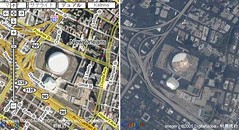
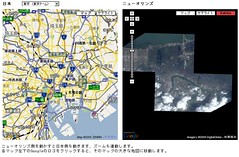
Japanese people who's never been to New Orleans nor US just don't guess viscerally what kind of large area is impacted by Katrina, even they saw the map, imagery and scales. So Ksc, who created railroad transfer mashup, made a mashup to compare imagery of Tokyo or Yokohama and New Orleans, so we can have a good sense of how large it is. Actually, New Orleans flood area looks like almost as large as Tokyo Metropolitan District area... that's unbelievable devastation so far.
Local Product Advertisement Shown as You Drag The Map
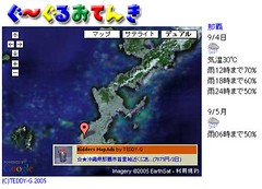
Every local towns you go in Japan, there are so unique local specials of any kind - from foods, dress to antiques. TEDDY-G, who created "Google Maps -> Blog", wrote a Google Maps mashup prototype with very unique advertisement model - as you drag the map, the ad banner of products from the displayed local area is shown in the map, and it's automatically changing as you keep dragging it - taking advantage of AJAX.
Bidders, one of the largest shopping/auction website, provides web service toolkits which allow developers to analyze the webpage and generates advertisement XML code of promoted product from their shopping/auction site, just like Google AdSense. So what this mushup does is reverse geocoding (convert coordinates to address) using invGeocoder, and give the address to toolkit to generate local product banner. It keep changing by AJAX technology.
He integrated it with local weather forecast mashup, so the screenshot below shows Okinawa area in the map, weather forecast (obviously severe because of typhoon Nabi), and the Bidders ad banner of Okinawan Awamori, the local special aged ardent spirit in a earthen pot.
He is planning to expand this prototype to "Google Maps -> Blog", and let users to use their own affiliate IDs of Bidders.
That's all for today.
nagoyan the earthhopper


0 comments:
Post a Comment