Vista Satellite is another satellite sightseeing web from Spain. If you have visited this kind of
site, you'll already be familiar with of some the places featured here.
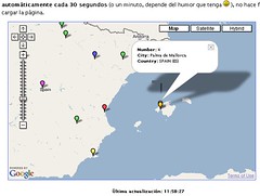
A Spanish professor at the University of the Balearic Islands, Ricardo Galli, has written a program that, installed in a site, features in a Google Map where people are accessing form. Galli mentions that his inspiration has been Mailinator, and has freely distributed his program (GPL) and has published instructions in Spanish. They have also produced some demo videos showing all accesses of a given site over 24 hours. Check the application running and view the videos at the end of the blog post. The image below showing the map centered in the island of Majorca, where Galli has created this thing.
Another interesting demo mash-up is the one created by Just Van denBroecke. He has worked over previous work to create new enhanced examples that add WMS layers to Google Maps, which permit mixing images from web-based GIS applications that deliver data in the WMS standard. One of the examples shows boundaries of municipalities and comarques (catalan shires or counties, we might say) plotted over Catalonia in Google Maps. The WMS layer is served, in this case, by the Cartographic Institute of Catalonia.
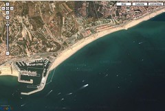
The result is truly interesting, but when zooming close we see that there is some mismatch in the coordinates. Click on the image to see the effect on the harbour of Arenys deMar. On the left side, you'll see also the municipality boundary with the town of Canet de Mar.
Meanwhile, the people at http://www.geocoder.com.ar are intensely developing their tool: they have translated the interface into English, now offer geocoding via HTTP requests, and they also do inverse geocoding: you click on a given point of a map showing Buenos Aires, and they return the street name on screen.


0 comments:
Post a Comment