
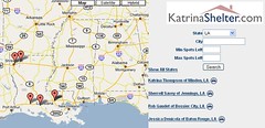
The earlier calls for volunteer developers in the Google Maps API forum must have been answered. KatrinaShelter.com has risen up as "an unfiltered database of individuals and groups all over the country who can provide temporary shelter for victims of Hurricane Katrina. We are a volunteer organization trying to coordinate the growing number of homes and shelters being opened to people left homeless and hungry by Katrina." The site has now integrated a Google Map to show locations of homes and shelters which are open to those who have been left homeless by Hurricane Katrina. The map is aggregating listings from sites like KatrinaHousing.org.
Katrina Before-and-After Viewing Tool

Note: if this link does not work, please copy and paste the following URL to visit this site: http://web.sfc.keio.ac.jp/~usuyu/map/gmaps/maps/050904_katrina_e.htm
Uz has created a convenient Google Maps viewing tool to make use of the recently released Aug.10 satellite imagery of the New Orleans area. The tool shows a side by side view of the before and after images. This tool can be used to help locate homes and communities.
Do you know of a Hurricane Katrina - Google Maps Integration? - Please post a comment to this blog-post and I will ensure that a link and details of the Google Maps integration get posted in future Google Maps Mania updates..
Technorati Tag: [katrina], [hurricanekatrina], [googlemaps], [New Orleans]


0 comments:
Post a Comment