When you visit Google Maps today you are greeted with this message in the top right of the page:
From Bret's instructions:
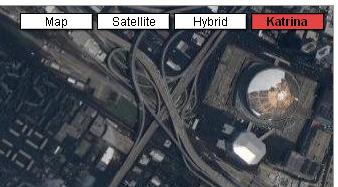
Enter "“New Orleans"” in the search field at the top of the page, or drag and zoom the map to the area. A red "Katrina" button will appear at the top right of the map, next to the existing map buttons. Older images for the area are still available too - click the "Satellite" button to switch to those.
Google promoting mashups:
Bret also goes on to say the following in his blog post:
API developers can also access this new imagery, which should aid the development of hurricane relief sites. Find more details at the Google Maps API discussion group.
This is an open call from Google to the web community to start creating Hurricane Katrina relief mashups. So far, the only Katrina-Google Maps site I know of is the Scipionus site. If you know of any other Katrina Google Maps mashups, please post a comment to this post and I will ensure that all visitors to my blog are made aware of these in a future posting.
Technorati Tag: [katrina], [hurricanekatrina], [googlemaps], [New Orleans]


0 comments:
Post a Comment